Freudenstadt
show This article may be expanded with text translated from the corresponding article in German. (May 2021) Click [show] for important translation instructions. |
Freudenstadt | |
|---|---|
 | |
 Coat of arms | |
show Location of Freudenstadt within Freudenstadt district | |
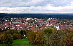
 Freudenstadt | |
| Coordinates: 48°27′48″N 8°24′40″E / 48.46333°N 8.41111°ECoordinates: 48°27′48″N 8°24′40″E / 48.46333°N 8.41111°E | |
| Country | Germany |
| State | Baden-Württemberg |
| Admin. region | Karlsruhe |
| District | Freudenstadt |
| Government | |
| • Mayor | Julian Osswald (CDU) |
| Area | |
| • Total | 87.58 km2 (33.81 sq mi) |
| Elevation | 732 m (2,402 ft) |
| Population (2020-12-31)[1] | |
| • Total | 23,760 |
| • Density | 270/km2 (700/sq mi) |
| Time zone | UTC+01:00 (CET) |
| • Summer (DST) | UTC+02:00 (CEST) |
| Postal codes | 72250 |
| Dialling codes | 07441, 07442, 07443 |
| Vehicle registration | FDS, HCH, HOR, WOL |
| Website | www |


Freudenstadt is a town in Baden-Württemberg in southern Germany. It is capital of the district Freudenstadt. The closest population centres are Offenburg to the west (approx. 36 km away) and Tübingen to the east (approx. 47 km away).
The city lies on a high plateau at the east edge of the north Black Forest, and is well known for its fresh air. Its city centre is famous as the largest market place in Germany. After Horb, it is the second largest city of the Freudenstadt district. The city has an administration partnership with the communities Bad Rippoldsau-Schapbach and Seewald.
Freudenstadt is a climatic health resort of international renown. In the 19th and 20th centuries, visitors of note included George V of the United Kingdom, the Queen of Sweden, John D. Rockefeller, and even the American writer Mark Twain. With its many hotels and guest houses, and its high-class cuisine, Freudenstadt remains a popular vacation spot for Germans from every part of the country. Among the many Germans of note who considered Freudenstadt a second home was the justice inspector Friedrich Kellner whose WWII diary is the subject of a Canadian documentary.
History[]
This section needs expansion. You can help by . (March 2017) |
Since 1535 a monastery church existed in Kniebis.[citation needed] The building of Freudenstadt was ordered by duke Frederick of Württemberg in 1599. The designer was architect Heinrich Schickhardt.[citation needed] In 1799 the monastery in Kniebis was burned down by the French.[citation needed] Because of the Württemberg foundation Freudenstadt was almost entirely Protestant for a long time.[citation needed] The young church belonged to the dean's office respectively church district Herrenberg within the Evangelical-Lutheran Church in Württemberg.[citation needed]
Third Reich and World War II[]
This section may lend undue weight to certain ideas, incidents, or controversies. Please help to create a more balanced presentation. Discuss and resolve this issue before removing this message. (March 2017) |
In World War II, on the nearly 1,000 meter high Kniebis, not far from the Alexanderschanze, a Command Center of the Armed Forces was built to defend the Western Front: the Führer's headquarter Tannenberg. Heavy Anti-aircraft warfare positions with the associated supply and accommodation buildings were built in the area as part of the LVZ West (Western Air Defense Zone), especially on the Schliffkopf and the Hornisgrinde.[2] In the Freudenstadt hospital many wounded were treated. Hitler's one-week visit to Tannenberg and Freudenstadt in 1940 (after the French campaign) at the inauguration of the headquarter was propaganda, which was reported in news reels. Thus, Freudenstadt including the nearby region in France has become a symbol of the Nazi regime and the French defeat, which in 1945 was to play an important role.
On 16 April 1945, three weeks before the war ended, the city was unexpectedly attacked by the troops of the under General Jean de Lattre de Tassigny. There was a large-scale destruction caused by bombing and shelling.[2] Freudenstadt fell, with interruptions, for about 16 hours under artillery fire. No residents dared to go to meet the French troops to surrender the city, conversely the French troops expected considerable military resistance.[3]
Since the water main line was destroyed by US air strikes and the main fire trucks had been destroyed by shelling, the fire could spread very well.[3] A handover took place only when the French troops had advanced to the town hall.[4] There were several dozen civilian casualties; about 600 buildings, 95 percent of the entire city, were destroyed directly or indirectly in the night from 16 to 17 April and 1,400 families afterwards were homeless. During the invasion of the French troops, and in the next three days there were many violent attacks by Moroccan units.[5] According to doctor Renate Lutz alone in her treatment have been more than 600 raped women.[6][7] On remonstrances civilians got the answer, according to reports from witnesses, it was war, Freudenstadt must burn three days.[8]
Many of the remaining buildings were then claimed by the French occupation troops.[citation needed] Many families lived in makeshift roofed cellars.[citation needed] Overall, the average living space per inhabitant was reduced to less than eight square meters.[citation needed] The need was great, and the cleanup of the debris was initially slow.[citation needed]
Main sights[]


The market place, flanked by arcaded houses, is the largest market place in Germany.[citation needed] The Rathaus (Town Hall), at the market place, houses the museum of local history.[citation needed]
On the south side of the market place is the Evangelical Lutheran Church, with its green tower roofs. It was built between 1601 and 1608, and is considered the most significant building of Freudenstadt. It was built in the Gothic/Renaissance style.[citation needed]
The Friedrichsturm (Frederick's Tower) is a 25m high tower which is built 799m above sea level on the Kienberg. It was built of red sandstone from the northern Black Forest in 1899 for the 300 year anniversary of Freudenstadt. On days with a clear sky it offers a view over the whole Murg valley, a view over Dornstetten and Schopfloch.[citation needed]
Cultural and social life[]
The following social institutions are present: The children's and youth workshop EIGEN-SINN aims to promote personal, social and academic skills of children and adolescents in social group work.[citation needed] The Erlacher Höhe is committed to ensure that people will have respect and value in social need and to reduce social exclusion.[citation needed] The Diakonisches Werk works for the poor, marginalized and disadvantaged. In children's center Freudenstadt (KiJuz) open child and youth work is offered for primary school children and adolescents.[citation needed] The Catholic young community (KJG) Freudenstadt is involved in child and youth work.[citation needed] Regional daily newspapers are the Schwarzwälder Bote and the Neckar Chronik of the Südwest Presse.
Economics[]
The value added comes in 2006 from the service sector (54,2%), the manufacturing industry (45,0%) and from agriculture (0,8%). 2007 were in the urban area 2,832 guest beds available. The number of overnight stays was 339,292.[9]
The manufacturing sector is located mainly in the industrial areas.[citation needed] Particularly significant are the Gebrüder Schmid (photovoltaic, printed circuit boards, flat panel displays), the Robert Bürkle (equipment for surface finishing), the company Georg Oest mineral (mineral oil, gas stations, mechanical engineering).[citation needed]
Roads[]
Due to the central location in the Black Forest, four federal roads lead through Freudenstadt. At the market place the B 28 (Kehl-Ulm) meets the B 462 (Rastatt-Rottweil). Here ends also the B 500 (Baden-Baden-Freudenstadt). Since 1985, the B 294 from Bretten to Gundelfingen bypasses Freudenstadt in a north–south direction.[10]
Bus and train[]
Freudenstadt is the starting point of three railway lines. In 1879 construction of the Eutingen im Gäu–Freudenstadt railway connected the city to the railway network. It runs from Stuttgart over Herrenberg and Eutingen im Gäu to Freudenstadt. Because continuation into the Kinzig valley was already planned (and as part of the Kinzig Valley Railway was carried out in 1886), the main station was built southeast of the city, relatively far from the center. In 1901 the Württemberg part of the Murg Valley Railway to Klosterreichenbach was built. The 60-meter higher Stadtbahnhof north of the center is a Standardized railway station.[11] In 1928, a direct connection to Rastatt (Baden) was established.
Eutingen and Stuttgart are connected with the Gäubahn. There is a rail service every hour with consolidations in school transport. Since 2006, coming from Karlsruhe, S41 goes every two hours about Freudenstadt up to Eutingen where is connection to the Regional Express (RE) Stuttgart-Singen.
The connection to Offenburg is via the Kinzig Valley Railway. The trains of the Ortenau-S-Bahn (OSB), connect Freudenstadt hourly over Alpirsbach, Schiltach and Hausach to Offenburg. The central bus station (ZOB) with more than 40 bus lines is a main transport hub in the Black Forest. City buses run to destinations in the urban core. Public transport to towns in neighboring districts, such as to Oberndorf, Wolfach, Altensteig or . On the nights of Saturdays, Sundays and holidays an overnight bus service completes the night rail service.
Administration[]
Freudenstadt is home of the Amtsgericht, which belongs to the court Rottweil and the superior court Stuttgart. It is the seat of the district office of the homonymous district and home to the majority of its administrative authorities. There is also a notary and a tax office. It is the seat of the church district Freudenstadt of the Evangelical-Lutheran Church in Württemberg.
Education[]
The schools sponsored by the city are on the one hand the Kepler-Gymnasium and the Kepler secondary school. Southeast towards the central station is the Falken-Realschule, not far away from the Hartranft Elementary School. The Theodor-Gerhard-primary school with integrated Werkrealschule as a second primary school of the main town is located opposite to the Kepler schools. Among the schools sponsored by the district are the Eduard-Spranger-School, a business school with an economic high school, the Heinrich-Schickhardt school as industrial and technical school with a technical high school and Luise Büchner School as domestic school with a nutritional scientific school. The Christopher's School, a special school, is found north the building yard.
Notable people[]
- Frederick I, Duke of Württemberg (1557–1608), founder of Freudenstadt
- Karl Burger (1883–1959), footballer
- George Lindemann (1884–1963), colonel general in World War II
- Klaus Mehnert (1906–1984), political journalist, publicist and author
- Margret Hofheinz-Döring (1910–1994), painter, lived here in 1953–1974
- Hermann Wagner (born 1941), physician
- Costa Cordalis (1944–2019), German-Greek pop singer; lived here
- Michael Volle (born 1960), operatic baritone
- Kevin Kurányi (born 1982), footballer; graduated 1997 from Kepler secondary school
- Petra Lammert (born 1984), track and field athlete in the discipline shot put
Twin towns – sister cities[]
Freudenstadt is twinned with:[12]
 Courbevoie, France
 Männedorf, Switzerland
 Sandanski, Bulgaria
References[]
| Wikimedia Commons has media related to Freudenstadt. |
- ^ "Bevölkerung nach Nationalität und Geschlecht am 31. Dezember 2020". Statistisches Landesamt Baden-Württemberg (in German). June 2021.
- ^ Jump up to: a b F. Wein (2010), Die Luftverteidigungszone West (in German), Explorate Verlag, ISBN 978-3-937779-25-6
- ^ Jump up to: a b Hans Rommel: Vor zehn Jahren 16./17. April 1945 – Wie es zur Zerstörung von Freudenstadt gekommen ist. In: Freudenstädter Heimatblätter. Beiheft 1 Freudenstadt: Oskar Kaupert 1955 56
- ^ Der deutsche Südwesten zur Stunde Null. Zusammenbruch und Neuanfang im Jahr 1945 in Dokumenten und Bildern. (paper back) Generallandesarchiv Karlsruhe (author). Publisher: Karlsruhe, Harschdruck, (1 January 1975)
- ^ Volker Kopp, Besetzt. Französische Besatzungspolitik in Deutschland (in German), Berlin: be.bra-Verlag
- ^ Bruhns, Annette. "Der Krieg gegen die Frauen". Der Ostfeldzug. Spiegel Special (in German) (2): 84.
- ^ Margarete Dörr, "Wer die Zeit nicht miterlebt hat…". Frauenerfahrungen im Zweiten Weltkrieg und in den Jahren danach (in German), Campus Verlag, p. 575, ISBN 3-593-36095-0
- ^ Bundesministerium für Vertriebene, Flüchtlinge und Kriegsgeschädigte, Dokumente deutscher Kriegsschäden (in German), p. 181
- ^ "Struktur- und Regionaldatenbank" (in German). Statistisches Landesamt Baden-Württemberg. Retrieved 1 February 2009.
- ^ Straßenbaubericht 1985 (PDF; 4,5 MB)
- ^ Rainer Stein (1996), "Der württembergische Einheitsbahnhof auf Nebenbahnen", Eisenbahn-Journal Württemberg-Report (in German), Fürstenfeldbruck: Merker, Band 1 (V/96), pp. 80–83, ISBN 3-922404-96-0
- ^ "Städtepartnerschaften". freudenstadt.de (in German). Freudenstadt. Retrieved 5 March 2021.
| show Important cities and tourist sites in |
|---|
| show Towns and municipalities in Freudenstadt (district) |
|---|
| show Authority control |
|---|
- Towns in Baden-Württemberg
- 1599 establishments in the Holy Roman Empire
- Freudenstadt (district)
- Populated places established in 1599
- Württemberg