Froschgrundsee
This article needs additional citations for verification. (December 2016) |
| Froschgrundsee | |
|---|---|
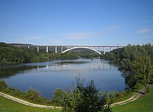 View of Froschgrundsee in 2009, in the back is the Froschgrundsee Bridge. | |
| Coordinates | 50°21′0″N 11°1′42″E / 50.35000°N 11.02833°ECoordinates: 50°21′0″N 11°1′42″E / 50.35000°N 11.02833°E |
| Construction began | 1982 - 1986 |
| Dam and spillways | |
| Height (foundation) | 18 m |
| Height (thalweg) | 3407 m |
| Length | 350 m |
| Elevation at crest | 359 m |
| Width (crest) | 9 m |
| Dam volume | 420000 m³ |
| Reservoir | |
| Total capacity | 69 Mio. m³ |
| Active capacity | 66 Mio. m³ |
| Catchment area | 11084 km² |
| Surface area | 94 ha |
| Normal elevation | 3445 m |

Froschgrundsee also known as Schönstädtspeicher is a retention basin to protect the city of Coburg in Bavaria from the flooding of the Itz, Effelder, and the Grümpen. It lies in the municipality of Rödental in Upper Franconia. Froschgrundsee was completed in 1986 after four years of construction and cost 43 million DM in operations.[1]
References[]
- ^ "Archived copy" (PDF). Archived from the original (PDF) on 2016-03-04. Retrieved 2016-12-07.
{{cite web}}: CS1 maint: archived copy as title (link)
This article about a bridge in Germany is a stub. You can help Wikipedia by . |
Categories:
- Geography of Bavaria
- Itz basin
- European bridge (structure) stubs
- Germany transport stubs
- German building and structure stubs