Frostisen
| Frostisen (Norwegian) Ruostajiekņa (Lule Sami) | |
|---|---|
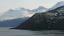 Frostisen mountains seen from the fjord | |
 Frostisen Location of the glacier | |
| Type | Plateau glacier |
| Location | Narvik Municipality, Nordland, Norway |
| Coordinates | 68°14′03″N 17°11′05″E / 68.2343°N 17.1848°ECoordinates: 68°14′03″N 17°11′05″E / 68.2343°N 17.1848°E |
| Area | 25 km2 (9.7 sq mi) |
| Highest elevation | 1,710 metres (5,610 ft) |
| Lowest elevation | 840 metres (2,760 ft) |
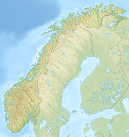

Frostisen (Norwegian) or Ruostajiekņa (Lule Sami) is a glacier in Narvik Municipality in Nordland county, Norway. It is one of the larger plateau glaciers in Norway. Frostisen covers an area of about 25 square kilometres (9.7 sq mi). The elevation of the glacier ranges from 840 to 1,710 metres (2,760 to 5,610 ft) above sea level. The glacier lies near the Skjomen fjord, a branch of the Ofotfjorden, just southwest of the town of Narvik. The village of Elvegård lies about 6 kilometres (3.7 mi) east of the glacier. The lakes Geitvatnet, , Kjelvatnet, and Søre Bukkevatnet all lie just to the southwest of the glacier.[1]
See also[]
References[]
- ^ Store norske leksikon. "Frostisen" (in Norwegian). Retrieved 2012-05-18.
This Nordland location article is a stub. You can help Wikipedia by . |
Categories:
- Ballangen
- Narvik
- Glaciers of Nordland
- Nordland geography stubs