Fuente Dé cable car
| Fuente Dé cable car Teleférico de Fuente Dé | |
|---|---|
 | |
| Overview | |
| Status | Operational |
| Location | Camaleño, Spain |
| Open | 1966 |
| Operation | |
| Owner | Cantur S.A. |
| Operator | Cantur S.A.[1] |
| Carrier capacity | 20 Passengers per cabin, 2 cabins |
| Trip duration | 3 min 40 |
| Technical features | |
| Line length | 1.45 kilometres (0.9 mi) |
| Vertical Interval | 753 m (2,470 ft) |
Fuente Dé cable car (in Spanish teleférico de Fuente Dé) is an aerial lift line of Cantabria (Spain).
History[]
The idea of connecting a high-mountain area in the heart of Picos de Europa with Fuente Dé was firstly developed by José Antonio Odriozola, former president of the ''Federación Española de Montañism (Spanish Mountaineering Federation[2]), whose family was from comarca of Liébana. The line was designed by engineer and architect . Its construction started in November 1962 and the opening ceremony was held on August 21, 1966.[3]
Features[]
The line covers a 753-metre (2,470 ft) vertical drop. Its bottom station is located at 1,090-metre (3,576 ft) and the upper one at 1,850-metre (6,070 ft). Cabins transport capacity is of 20 people and the trip, which does not have intermediate stops, lasts 3'40". The line has a single span and two independent sections with one cabin each, that can be operated separately. Cables length is 1,450-metre (4,757 ft) and the speed of cabins is usually 10-metre (33 ft)/s[4] Fuente Dé ropeway is the longest single-span aerial lift of Europe.[5]
Image gallery[]

Bottom station

An old-style cabin (2007)
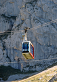
Present-day cabin (2016)
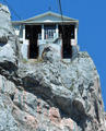
Upper station


References[]
| Wikimedia Commons has media related to Teleférico de Fuente Dé. |
- ^ Sociedad Regional Cántabra de Promoción Turística, public society of Government of Cantabria
- ^ "José Antonio Odriozola Calvo". Retrieved 2017-01-29.
- ^ Esteban, Blanca (2010-02-25). "Fuente Dé, un teleférico especial" (in Spanish). Retrieved 2017-01-28.
- ^ "Teleférico de Fuente Dé" (in Spanish). CANTUR. Retrieved 2017-01-28.
- ^ Steves, Rick (2015). Rick Steves Spain 2016. Avalon Travel. Archived from the original on 2017-02-02. Retrieved 2017-01-28.
External links[]
- Cableway officiale site: Teleférico de Fuente Dé

- Aerial tramways in Spain
- Transport in Cantabria
- Picos de Europa
- 1966 establishments in Spain