Fyris
| Fyris River | |
|---|---|
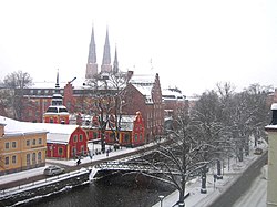 The Fyris River in winter as seen from a hotel window in central Uppsala. | |
| Native name | [Fyrisån] Error: {{Native name}}: missing language tag (help) (language?) |
| Location | |
| Country | Sweden |
| Physical characteristics | |
| Mouth | Mälaren |
• coordinates | 59°47′12″N 17°39′20″E / 59.78667°N 17.65556°ECoordinates: 59°47′12″N 17°39′20″E / 59.78667°N 17.65556°E |
| Length | 80 km (50 mi)[1] |
| Basin size | 1,982 km2 (765 sq mi)[1] |
| Discharge | |
| • average | 14 m3/s (490 cu ft/s)[1] |


Fyrisån (Swedish pronunciation: [ˈfŷːrɪsˌoːn], "the Fyris river") is a river in the Swedish province of Uppland, which passes through the city of Uppsala and ends in Lake Mälaren.
The "Sala" river in Uppland was changed in the 17th century in memory of the Fyrisvellir battle, mentioned in the Icelandic sagas. Since it was the belief that the marshy plains called "Föret" was the site of the famous Battle of Fýrisvellir in the late 10th century.
Boats can sail up the river from Lake Mälaren all the way to central Uppsala where two weirs make further progress impossible. In the summer of 2007 the construction of a fish ladder was started,[2] in order to make it possible for the asp, an endangered and potamodromous fish, to pass the weirs and reach its spawning waters. On the last day of April every year, students attempt to navigate the weirs on homemade rafts with predictable results.
References[]
![]() Media related to Fyrisån at Wikimedia Commons
Media related to Fyrisån at Wikimedia Commons
- ^ a b c "Fyrisån". Nationalencyklopedin (in Swedish). Retrieved 11 July 2010. (subscription required)
- ^ Daniel Jansson (2007-11-22). "Aspen får trappa i Islandsfallet" (in Swedish). Upsala Nya Tidning. Archived from the original on 23 November 2007. Retrieved 24 December 2007.
- Uppland
- Rivers of Uppsala County
- Norrström basin