Gèdre
Gèdre | |
|---|---|
Part of Gavarnie-Gèdre | |
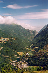 The village of Gèdre and the valley of the | |
 Coat of arms | |
show Location of Gèdre | |
 Gèdre | |
| Coordinates: 42°47′14″N 0°01′12″E / 42.7872°N 0.02°ECoordinates: 42°47′14″N 0°01′12″E / 42.7872°N 0.02°E | |
| Country | France |
| Region | Occitanie |
| Department | Hautes-Pyrénées |
| Arrondissement | Argelès-Gazost |
| Canton | La Vallée des Gaves |
| Commune | Gavarnie-Gèdre |
| Area 1 | 14.46 km2 (5.58 sq mi) |
| Population (2017)[1] | 230 |
| • Density | 16/km2 (41/sq mi) |
| Time zone | UTC+01:00 (CET) |
| • Summer (DST) | UTC+02:00 (CEST) |
| Postal code | 65120 |
| Elevation | 905–3,194 m (2,969–10,479 ft) (avg. 1,000 m or 3,300 ft) |
| 1 French Land Register data, which excludes lakes, ponds, glaciers > 1 km2 (0.386 sq mi or 247 acres) and river estuaries. | |


Gèdre (Gascon: Gèdra) is a former commune in the Hautes-Pyrénées department in south-western France. On 1 January 2016, it was merged into the new commune of Gavarnie-Gèdre.[2]
See also[]
References[]
| Wikimedia Commons has media related to Gèdre. |
This Hautes-Pyrénées geographical article is a stub. You can help Wikipedia by . |
Categories:
- Former communes of Hautes-Pyrénées
- Hautes-Pyrénées geography stubs