Göbekli Tepe
| |
 | |
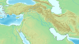
 Shown within Turkey | |
| Location | Şanlıurfa Province, Turkey |
|---|---|
| Region | Southeastern Anatolia |
| Coordinates | 37°13′23″N 38°55′21″E / 37.22306°N 38.92250°ECoordinates: 37°13′23″N 38°55′21″E / 37.22306°N 38.92250°E |
| History | |
| Founded | c. 9500 BCE[1] |
| Abandoned | c. 8000 BCE[1] |
| Periods | |
| Site notes | |
| Discovered | 1963 |
| Excavation dates | 1995–present |
| Archaeologists | |
| Condition | Well-preserved |
UNESCO World Heritage Site | |
| Official name | Göbekli Tepe |
| Type | Cultural |
| Criteria | (i), (ii), (iv) |
| Designated | 2018 (42nd session) |
| Reference no. | 1572 |
| State party | Turkey |
| Region | Western Asia |

Göbekli Tepe (Turkish: [gœbecˈli teˈpe],[2] "Potbelly Hill";[3] known as Girê Mirazan or Xirabreşkê in Kurdish[4]) is a Neolithic archaeological site near the city of Şanlıurfa in Southeastern Anatolia, Turkey. Dated to the Pre-Pottery Neolithic, between c. 9500 and 8000 BCE, the site comprises a number of large circular structures supported by massive stone pillars – the world's oldest known megaliths. Many of these pillars are richly decorated with abstract anthropomorphic details, clothing, and reliefs of wild animals, providing archaeologists a rare insights into prehistoric religion and the particular iconography of the period. The 15 m (50 ft)-high, 8 ha (20 acres) tell also includes many smaller rectangular buildings, quarries, and stone-cut cisterns from the Neolithic, as well as some traces of activity from later periods.
The site was first used at the dawn of the Neolithic period, which in Southwest Asia marks the appearance of the oldest permanent human settlements anywhere in the world. Prehistorians link this Neolithic Revolution to the advent of agriculture, but disagree on whether farming caused people to settle down or vice-versa. Göbekli Tepe, a monumental complex built on the top of a rocky mountaintop, far from known sources of water and to date producing no clear evidence of agricultural cultivation, has played a prominent role in this debate. The site's original excavator, German archaeologist Klaus Schmidt, described it as the "world's first temple": a sanctuary used by groups of nomadic hunter-gatherers from a wide area, with few or no permanent inhabitants. Other archaeologists challenged this interpretation, arguing that the evidence for a lack of agriculture and a resident population was far from conclusive. Recent research has also led the current excavators of Göbekli Tepe to revise or abandon many of the conclusions underpinning Schmidt's interpretation.[1]
First noted in a survey in 1963, the importance of the site was recognised by Schmidt, who directed excavations there from 1995 until his death in 2014. Since then, work has continued under the auspices of Istanbul University, Şanlıurfa Museum, and the German Archaeological Institute, under the overall direction of Turkish prehistorian . It was designated a UNESCO World Heritage Site in 2018, recognising its outstanding universal value as "one of the first manifestations of human-made monumental architecture".[5] As of 2021, less than 5% of the site has been excavated.[6]
Background
Göbekli Tepe was built and occupied during the Pre-Pottery Neolithic (PPN)—the earliest division of the Neolithic period in Southwest Asia—which is dated to between 9600 and 7000 BCE.[7] Beginning at the end of the last Ice Age, the PPN marks "the beginnings of village life",[8] producing the earliest evidence for permanent human settlements in the world.[8][9] Archaeologists have long associated the appearance of these settlements with the Neolithic Revolution—the transition from hunting and gathering to agriculture—but disagree on whether the adoption of farming caused people to settle down, or settling down caused people to adopt farming.[10] Despite the name, the Neolithic Revolution in Southwest Asia was "drawn out and locally variable".[11] Elements of village life appeared as early as 10,000 years before the Neolithic in places,[12][13] and the transition to agriculture took thousands of years, with different paces and trajectories in different regions.[14][15] The Pre-Pottery Neolithic is divided into two subperiods: the PPNA, to which the early phases of Göbekli Tepe belong, is dated to between 9600 and 8800 BCE; the PPNB, to which the late phases of Göbekli Tepe belong, is dated to between 8800 and 7000 BCE.[9] It was preceded by the Epipalaeolithic and succeeded by the Late Neolithic.[8]
Evidence indicates that the inhabitants were hunter-gatherers who supplemented their diet with early forms of domesticated cereal and lived in villages for at least part of the year. Tools such as grinding stones and mortar & pestle, found at Göbekli Tepe, were analyzed and suggest considerable cereal processing. Archaeozoological evidence hints at "large-scale hunting of gazelle between midsummer and autumn."[16]

PPN villages consisted of clusters of stone or mud brick houses,[8] and sometimes substantial monumental or 'communal' buildings.[9] The T-shaped pillar tradition seen at Göbekli Tepe is unique to the Urfa region, but is found at the majority of PPN sites there.[20] These include Nevalı Çori, ,[21] Karahan Tepe,[22] ,[19] ,[20] and .[18] Other stone stelae—without the characteristic T shape—have been documented at contemporary sites further afield, including Çayönü, Qermez Dere, and .[23]
Geography and environment
Göbekli Tepe is located in the foothills of the Taurus Mountains, overlooking the [24] and the headwaters of the Balikh River, a tributary of the Euphrates.[25] The site is a tell (artificial mound) situated on a flat limestone plateau.[26] In the north, the plateau is connected to the neighbouring mountains by a narrow promontory. In all other directions, the ridge descends steeply into slopes and steep cliffs.[27] On top of the ridge there is considerable evidence of human impact, in addition to the construction of the tell.[clarification needed][citation needed]
Excavations have taken place at the southern slope of the tell, south and west of a mulberry that marks an Islamic pilgrimage,[28] but archaeological finds come from the entire plateau. The team has also found many remains of tools. At the western escarpment, a small cave has been discovered in which a small relief depicting a bovid was found. It is the only relief found in this cave.[29]
Like most PPN sites in the Urfa region, Göbekli Tepe was built on a high point on the edge of the mountains, giving it both a wide view over plain beneath, and good visibility from the plain.[17] This location also gave the builders good access to raw material: the soft limestone bedrock from which the complex was built, and the flint to make the tools to work the limestone.[17]

At the time when Göbekli Tepe was occupied, the climate of the area was warmer and wetter than it is today.[26] It was surrounded by an open steppe grassland,[26] with abundant wild cereals, including einkorn, wheat, and barley,[30] and herds of grazing animals such as wild sheep, wild goat, gazelle, and equids.[31] Large herds of goitered gazelle may have passed by the site in seasonal migrations.[32] There is no evidence of substantial woodlands nearby;[26] 90% of the charcoal recovered at the site was from pistachio or almond trees.[30] Archaeologists disagree on whether the site provided ready access to drinking water. Schmidt maintained that there was "no access to water in the immediate vicinity",[33] based on the fact that, whilst there are many karstic springs and small streams in the Germuş,[34][35] the closest today are several kilometres away.[36] However, in the wetter climate of the time, the local water table may have been higher, activating springs closer to the site that are dormant today.[37] Schmidt also noted the presence of several cisterns carved into the bedrock under the site,[36] holding at least 150 cubic metres (5,300 cu ft) of water,[16] and subsequent excavation has uncovered a possible rainwater harvesting system.[38]
Chronology
| Lab-Number | Context | Material | cal BCE |
|---|---|---|---|
| KIA-28407 | Enclosure A, under fallen pillar fragment | charcoal | 8617-8315 |
| Hd-20025 | Enclosure A, Layer III | charcoal | 9131–8559 |
| Hd-20036 | Enclosure A, Layer III | charcoal | 9160–8759 |
| Ua-19562 | Enclosure B, pillar 8 | lime sinter | 8280–7970 |
| Ua-19561 | Enclosure C, pillar 11 | lime sinter | 7560–7370 |
| UGAMS-10797 | Enclosure C, between outer ringwalls | charcoal | 9261-9139 |
| IGAS-2658 | Enclosure D, TAQ for Layer II | soil sample | 8241-7813 |
| KIA-44701 | Enclosure D, filling | cattle tooth | 9676-8818 |
| KIA-44149 | Enclosure D | wall plaster | 9675–9314 |
| UGAMS-10796 | Enclosure D, adjacent to ring walls | charcoal | 9664-9334 |
| KIA-42208 | Enclosure F | 7536-7350 | |
| KIA-42211 | Enclosure G | 7056-6749 |
Radiocarbon dating shows that the earliest exposed structures at Göbekli Tepe were built between 9500 and 9000 BCE, towards the end of the Pre-Pottery Neolithic A (PPNA) period.[42][43] The site was significantly expanded in the early 9th millennium BCE and remained in use until around 8000 BCE, or perhaps slightly later (the early Pre-Pottery Neolithic B, PPNB).[43] There is evidence that smaller groups returned to live amongst the ruins after the Neolithic structures were abandoned.[43]
Schmidt originally dated the site to the PPN based on the types of stone tools found there, considering a PPNA date "most probable".[44] Establishing its absolute chronology took longer due to methodological challenges.[45][41] Though the first two radiocarbon dates were published in 1998,[39] these and other samples from the fill of the structure dated to the late 10th and early 9th millennium – 500 to 1000 years later than expected for a PPNA site.[45] Schmidt's team explained the discrepancy in light of their theory that this material was brought to the site from elsewhere when it was abandoned, and so was not representative of the actual use of the structures.[45][41] They instead turned to a novel method of dating organic material preserved in the plaster on the structure's walls, which resulted in dates more consistent with a PPNA occupation, in the middle or even early 10th millennium BCE.[46][40][42] Subsequent research has to led to a significant revision of Schmidt's chronology, including the abandonment of the theory that the fill of the structures was brought from elsewhere, and a recognition that direct dates on plaster are affected by the old wood effect.[47] Together with new radiocarbon dates, this has established the site's as absolute chronology as falling in the period 9500 to 8000 BCE – the late PPNA and PPNB.[1][47]
Architecture

Göbekli Tepe follows a geometric pattern. The pattern is an equilateral triangle that connects enclosures A, B, and D. A 2020 study of "Geometry and Architectural Planning at Göbekli Tepe" suggests that enclosures A, B, and D are all one complex, and within this complex there is a "hierarchy" with enclosure D at the top, rejecting the idea that each enclosure was built and functioned individually as less likely.[48]
Enclosure A
Enclosure C

Complex E


Tell
At the western edge of the hill, a lionlike figure was found. In this area, flint and limestone fragments occur more frequently. It was therefore suggested that this could have been some kind of sculpture workshop.[49] It is unclear, on the other hand, how to classify three phallic depictions from the surface of the southern plateau. They are near the quarries of classical times, making their dating difficult.[29]
Apart from the tell, there is an incised platform with two sockets that could have held pillars, and a surrounding flat bench. This platform corresponds to the complexes from Layer III at the tell. Continuing the naming pattern, it is called "complex E". Owing to its similarity to the cult-buildings at Nevalı Çori it has also been called "Temple of the Rock". Its floor has been carefully hewn out of the bedrock and smoothed, reminiscent of the terrazzo floors of the younger complexes at Göbekli Tepe. Immediately northwest of this area are two cistern-like pits that are believed to be part of complex E. One of these pits has a table-high pin as well as a staircase with five steps.[50]
Layer III
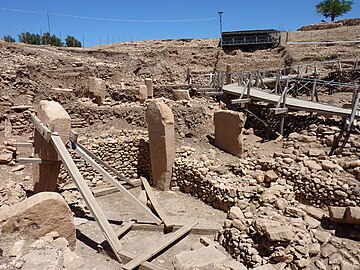
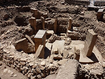
At this early stage of the site's history, circular compounds or temene first appear. They range from 10 to 30 metres in diameter. Their most notable feature is the presence of T-shaped limestone pillars evenly set within thick interior walls composed of unworked stone. Four such circular structures have been unearthed so far. Geophysical surveys indicate that there are 16 more, enclosing up to eight pillars each, amounting to nearly 200 pillars in all. The slabs were transported from bedrock pits located approximately 100 metres (330 ft) from the hilltop, with workers using flint points to cut through the limestone bedrock.[51]
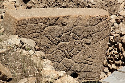
Two taller pillars stand facing one another at the centre of each circle. Whether the circles were provided with a roof is uncertain. Stone benches designed for sitting are found in the interior.[52] Many of the pillars are decorated with abstract, enigmatic pictograms and carved animal reliefs. The pictograms may represent commonly understood sacred symbols, as known from Neolithic cave paintings elsewhere. The reliefs depict mammals such as lions, bulls, boars, foxes, gazelles, and donkeys; snakes and other reptiles; arthropods such as insects and arachnids; and birds, particularly vultures. At the time the edifice was constructed, the surrounding country was likely to have been forested and capable of sustaining this variety of wildlife, before millennia of human settlement and cultivation led to the near–Dust Bowl conditions prevalent today.[53] Vultures also feature prominently in the iconography of Çatalhöyük and Jericho.
Few humanoid figures have appeared in the art at Göbekli Tepe. Some of the T-shaped pillars have human arms carved on their lower half, however, suggesting to site excavator Schmidt that they are intended to represent the bodies of stylized humans (or perhaps deities). Loincloths appear on the lower half of a few pillars. The horizontal stone slab on top is thought by Schmidt to symbolize shoulders, which suggests that the figures were left headless.[54] Whether they were intended to serve as surrogate worshippers, symbolize venerated ancestors, or represent supernatural, anthropomorphic beings is not known.
Some of the floors in this, the oldest, layer are made of terrazzo (burnt lime); others are bedrock from which pedestals to hold the large pair of central pillars were carved in high relief.[55] Radiocarbon dating places the construction of these early circles around 9000 BCE. Carbon dating suggests that (for reasons unknown) the enclosures were backfilled during the Stone Age.
Layer II
Creation of the circular enclosures in layer III later gave way to the construction of small rectangular rooms in layer II. Rectangular buildings make a more efficient use of space compared with circular structures. They often are associated with the emergence of the Neolithic,[56] but the T-shaped pillars, the main feature of the older enclosures, also are present here, indicating that the buildings of Layer II continued to serve the same function in the culture, presumably as sanctuaries.[57] Layer II is assigned to Pre-Pottery Neolithic B (PPNB). The several adjoining rectangular, doorless and windowless rooms have floors of polished lime reminiscent of Roman terrazzo floors. Carbon dating has yielded dates between 8800 and 8000 BCE.[58] Several T-pillars up to 1.5 meters tall occupy the center of the rooms. A pair decorated with fierce-looking lions is the rationale for the name "lion pillar building" by which their enclosure is known.[59]
A stone pillar resembling totem pole designs was discovered at Göbekli Tepe, Layer II in 2010. It is 1.92 metres high, and is superficially reminiscent of the totem poles in North America. The pole features three figures, the uppermost depicting a predator, probably a bear, and below it a human-like shape. Because the statue is damaged, the interpretation is not entirely clear. Fragments of a similar pole also were discovered about 20 years ago in another site in Turkey at Nevalı Çori. Also, an older layer at Gobekli features some related sculptures portraying animals on human heads.[60]
Layer I
Layer I is the uppermost part of the hill. It is the shallowest, but accounts for the longest stretch of time. It consists of loose sediments caused by erosion and the virtually-uninterrupted use of the hill for agricultural purposes since it ceased to operate as a ceremonial center.
Around the beginning of the 8th millennium BCE Göbekli Tepe lost its importance. The advent of agriculture and animal husbandry brought new realities to human life in the area, and the "Stone-age zoo" (Schmidt's phrase applied particularly to Layer III, Enclosure D) apparently lost whatever significance it had had for the region's older, foraging communities. However, the complex was not simply abandoned and forgotten to be gradually destroyed by the elements. Instead, each enclosure was deliberately buried under as much as 300 to 500 cubic meters (390 to 650 cu yd) of refuse, creating a tell consisting mainly of small limestone fragments, , and stone tools. Many animal and even human bones have been identified in the fill.[61] The site was deliberately backfilled sometime after 8000 BCE: the buildings were buried under debris, mostly flint gravel, stone tools, and animal bones.[62] In addition to Byblos points (weapon heads, such as arrowheads etc.) and numerous Nemrik points, Helwan-points, and Aswad-points dominate the backfill's lithic inventory.
Construction
The plateau Göbekli Tepe is situated on has been shaped by erosion by quarrying in both the Neolithic and later periods. There are four 10-metre-long (33 ft) and 20-centimetre-wide (7.9 in) channels on the southern part of the plateau, interpreted as the remains of an ancient quarry from which rectangular blocks were taken. These possibly are related to a square building in the neighbourhood, of which only the foundation is preserved. Presumably this is the remains of a Roman watchtower that was part of the Limes Arabicus, though this is conjecture.[63] Most structures on the plateau seem to be the result of Neolithic quarrying, with the quarries being used as sources for the huge, monolithic architectural elements. Their profiles were pecked into the rock, with the detached blocks then levered out of the rock bank.[63] Several quarries where round workpieces had been produced were identified. Their status as quarries was confirmed by the find of a 3-by-3 metre piece at the southeastern slope of the plateau. Unequivocally Neolithic are three T-shaped pillars that had not yet been levered out of the bedrock. The largest of them lies on the northern plateau. It has a length of 7 m (23 ft) and its head has a width of 3 m (10 ft). Its weight may be around 50 tons. The two other unfinished pillars lie on the southern Plateau.[citation needed]
Archaeologists disagree on how much labour was needed to construct the site. Schmidt maintained that "the work of quarrying, transporting, and erecting tons of heavy, monolithic, and almost universally well-prepared limestone pillars [...] was not within the capability of a few people".[64] Using Thor Heyerdahl's experiments with the moai of Rapa Nui as a reference, he estimated that moving the pillars alone must have involved hundreds of people.[37] According to these experiments, one moai of similar size to a T-shaped pillar from Göbekli Tepe would have taken 20 people a year to carve, and 50–75 people a week to transport 15 km.[65] Schmidt's team have also cited a 1917 account of the construction of a megalith on the Indonesian island of Nias, which took 525 people three days.[37][65] These estimates underpin their interpretation that the site was built by a large, non-resident workforce,[66] coerced or enticed there by a small religious elite.[67][68] According to other estimates, just 7–14 people could have moved the pillars using ropes and water or another lubricant, with techniques used to construct other monuments such as Stonehenge.[37] Experiments on the site have suggested that all the PPNB structures currently exposed could have been built by 12–24 people in less than four months, allowing for time spent quarrying stone and gathering, and preparing food.[69] These labour estimates are thought to be within the capability of a single extended family or village community in the Neolithic.[37] They also match the number of people that could have comfortably been inside one of the buildings at the same time.[70]
Art
Iconography of the pillars
The pillars in the enclosures at Göbekli Tepe are T-shaped, similar to other PPN sites in the region.[71] But unlike at these other sites, many of the pillars are carved – usually in bas relief, but sometimes also in high relief. The carvings most commonly depict animals: serpents, foxes, and boars for the most part, but also aurochs, gazelle, mouflon (wild sheep), onager, crane, ducks and vultures. Insofar as they can be identified, the animals are male, and often depicted with an aggressive posture.[72][73]
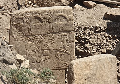
Abstract shapes are also depicted, mostly an upright or horizontal H-shaped symbol, but also crescents and disks. Depictions of humans are rare; pillar 43 in enclosure D includes a headless man with an erect phallus. However, the T-shape of the pillars themselves is anthropomorphic: the shaft is the body, and the top the head. This is confirmed by the fact that some pillars include—in addition to animal reliefs—carvings of arms, hands and loincloths.[74]
Pillar 2, Enclosure A, Pillar 2: aurochs, duck and crane.

Pillar 10, Enclosure B: fox.
Pillar 12, Enclosure C: birds.

Pillar 27, Enclosure C: predator (possibly a felid) in high relief, hunting prey in low relief

Pillar 37 (central), Enclosure C: fox.
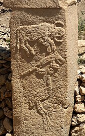
Pillar 43, Enclosure D: the "Vulture Stone"

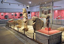
Reproduction of the central pillars of Enclosure D in the Şanlıurfa museum: engraved arms are visible on the shaft.


The two central pillars occupied a special place in the symbolic architecture of the enclosures. Those in Enclosure D represent humans, with arms, a belt, and a piece of cloth that hides the genitals. The sex of the individuals depicted cannot be clearly identified, though Schmidt suggested that they are two men because the belts they were are a male attribute in the iconography of the period. There is only one certain representation of a woman, depicted naked on a slab.[74]
Other objects
The structures at Göbekli Tepe have also yielded a number of smaller carved stones, which typically cannot be attributed to one period or another. The iconography of these objects is similarly diverse to that of the pillars, mostly depicting animals, but also humans, again primarily male.[75][76]

Carved stone with an (possibly a reptile, felid, or wolverine) in high relief.

Boar statuette with legs.

Boar statuette without legs.

Head of an animal.


A broken "totem" was discovered in one of the structures in Layer II. Reassembled, it is 1.92 m high and 30 cm in diameter. It depicts three figures (from top to bottom): a predator (a bear or large felid) with a missing head, and the neck and arms of a human; another figure missing a head with human arms, likely male; and a third figure with a preserved head. Snakes are carved on either side.[77]
Interpretation
Klaus Schmidt's view was that Göbekli Tepe is a stone-age mountain sanctuary. Radiocarbon dating as well as comparative stylistical analysis indicate that it contains the oldest known megaliths yet discovered anywhere, and that these ruins may constitute the remains of a temple.[53][78] Schmidt believed that what he called this "cathedral on a hill" was a pilgrimage destination attracting worshippers up to 150 km (90 mi) distant. Butchered bones found in large numbers from local game such as deer, gazelle, pigs, and geese have been identified as refuse from food hunted and cooked or otherwise prepared for the congregants.[79] Zooarchaeological analysis shows that gazelle were only seasonally present in the region, suggesting that events such as rituals and feasts were likely timed to occur during periods when game availability was at its peak.[32]
Schmidt considered Göbekli Tepe a central location for a cult of the dead and that the carved animals are there to protect the dead. Though no tombs or graves have yet been found, Schmidt believed that graves remain to be discovered in niches located behind the walls of the sacred circles.[53] In 2017, discovery of human crania with incisions was reported, interpreted as providing evidence for a new form of Neolithic skull cult.[7] Special preparation of human crania in the form of plastered human skulls is known from the Pre-Pottery Neolithic B period at sites such as 'Ain Mallaha, Tell es-Sultan (also known as Jericho), and Yiftahel.
Schmidt also interpreted the site in connection with the initial stages of the Neolithic.[53] It is one of several sites in the vicinity of Karaca Dağ, an area that geneticists suspect may have been the original source of at least some of our cultivated grains (see Einkorn). Recent DNA analysis of modern domesticated wheat compared with wild wheat has shown that its DNA is closest in sequence to wild wheat found on Karaca Dağ 30 km (20 mi) away from the site, suggesting that this is where modern wheat was first domesticated.[80]
With its mountains catching the rain and a calcareous, porous bedrock creating many springs, creeks, and rivers,[18] the upper reaches of the Euphrates and Tigris was a refuge during the dry and cold Younger Dryas climatic event (10,800–9,500 BCE).[citation needed]
Schmidt also engaged in speculation regarding the belief systems of the groups that created Göbekli Tepe, based on comparisons with other shrines and settlements. He presumed shamanic practices and suggested that the T-shaped pillars represent human forms, perhaps ancestors, whereas he saw a fully articulated belief in deities as not developing until later, in Mesopotamia, that was associated with extensive temples and palaces. This corresponds well with an ancient Sumerian belief that agriculture, animal husbandry, and weaving were brought to humans from the sacred mountain Ekur, which was inhabited by Annuna deities, very ancient deities without individual names. Schmidt identified this story as a primeval oriental myth that preserves a partial memory of the emerging Neolithic.[81] It is apparent that the animal and other images give no indication of organized violence, i.e. there are no depictions of hunting raids or wounded animals, and the pillar carvings generally ignore game on which the society depended, such as deer, in favour of formidable creatures such as lions, snakes, spiders, and scorpions.[53][82][83] Expanding on Schmidt's interpretation that round enclosures could represent sanctuaries, Gheorghiu's semiotic interpretation reads the Göbekli Tepe iconography as a cosmogonic map that would have related the local community to the surrounding landscape and the cosmos.[84]
According to Lee Clare a revision of the temple-narrative is unavoidable due to new observations related to the "existence of domestic buildings and the harvesting and distribution of rain-water."[1]
Importance
Göbekli Tepe is regarded by some as an archaeological discovery of great importance since it could profoundly change the understanding of a crucial stage in the development of human society.[3] Some researchers believe that the construction of Göbekli Tepe may have contributed to the later development of urban civilization, or, as excavator Klaus Schmidt put it, "First came the temple, then the city."[85]
It remains unknown how a population large enough to construct, augment, and maintain such a substantial complex was mobilized and compensated or fed in the conditions of pre-sedentary society. Scholars have been unable to interpret the pictograms, and do not know what meaning the animal reliefs had for visitors to the site. The variety of fauna depicted – from lions and boars to birds and insects – makes any single explanation problematic. As there is little or no evidence of habitation, and many of the animals pictured are predators, the stones may have been intended to stave off evils through some form of magic representation. Alternatively, they could have served as totems.[86]
The assumption that the site was strictly cultic in purpose and not inhabited has been challenged as well by the suggestion that the structures served as large communal houses, "similar in some ways to the large plank houses of the Northwest Coast of North America with their impressive house posts and totem poles."[37] It is not known why every few decades the existing pillars were buried to be replaced by new stones as part of a smaller, concentric ring inside the older one.[87]
Research history

Before being documented by archaeologists, the hill Göbekli Tepe stands on, known locally in Kurdish as Girê Mirazan or Xerabreşk, was considered a sacred place.[88][89]
The archaeological site was first noted in a survey conducted by Istanbul University and the University of Chicago in 1963.[90] American archaeologist Peter Benedict identified the stone tools collected from the surface of site as characteristic of the Aceramic Neolithic,[91] but apparently mistook the upper parts of the T-shaped pillars for grave markers.[92] The hill had long been under agricultural cultivation, and generations of local inhabitants had frequently moved rocks and placed them in clearance piles, which may have disturbed the upper layers of the site. At some point attempts had been made to break up some of the pillars, presumably by farmers who mistook them for ordinary large rocks.[53]
In October 1994,[93] German archaeologist Klaus Schmidt, who had previously been working at Nevalı Çori, was looking for evidence of similar sites in the area and decided to re-examine the location described by the Chicago researchers in 1963.[53][93] Asking in nearby villages about hills with flint,[93] he was guided to Göbekli Tepe by Mahmut and İbrahim Yıldız, the farmers who owned the land the site was situated on.[89] Mahmut Yıldız and his father had previously discovered finds while ploughing there, which they reported to the local museum.[89] Having found similar structures at Nevalı Çori, Schmidt recognized the possibility that the stone slabs were not grave markers as supposed by Benedict, but the tops of prehistoric megaliths. He began excavations the following year and soon unearthed the first of the huge T-shaped pillars.[53] Ultimately he found only three tombs on the eastmost hill-group, which were a pilgrimage destination.[94] Yıldız went on to work on the excavations and serve as the site's guard.[89]
Schmidt continued to direct excavations at the site on behalf of the Şanlıurfa Museum and the German Archaeological Institute (DAI) until his death in 2014. Since then, the DAI's research at the site has been coordinated by .[95][1] As of 2021, work on the site is conducted jointly by Istanbul University, the Şanlıurfa Museum, and the DAI, under the overall direction of .[96][97] Recent excavations have been more limited than Schmidt's, focusing on detailed documentation and conservation of the areas already exposed.[97]
Conservation

Future plans include construction of a museum and converting the environs into an archaeological park, in the hope that this will help preserve the site in the state in which it was discovered.[28]
In 2010, Global Heritage Fund (GHF) announced it will undertake a multi-year conservation program to preserve Göbekli Tepe. Partners include the German Archaeological Institute, German Research Foundation, Şanlıurfa Municipal Government, the Turkish Ministry of Tourism and Culture and, formerly, Klaus Schmidt.[98]
The stated goals of the GHF Göbekli Tepe project are to support the preparation of a site management and conservation plan, construction of a shelter over the exposed archaeological features, training community members in guiding and conservation, and helping Turkish authorities secure UNESCO World Heritage Site designation for GT.[99]
The conservation work caused controversy in 2018, when Çiğdem Köksal Schmidt, an archaeologist and widow of Klaus Schmidt, said the site was being damaged by the use of concrete and "heavy equipment" during the construction of a new walkway. The Ministry of Culture and Tourism responded that no concrete was used and that no damage had occurred.[100][101]
See also
- Gürcütepe
- List of archaeological sites by continent and age
- List of largest monoliths
- Natufian culture
- Prehistoric religion
Notes
- ^ Jump up to: a b c d e f Clare 2020.
- ^ "Göbekli Tepe". Forvo Pronunciation Dictionary.
- ^ Jump up to: a b Symmes 2010.
- ^ Kosen, Hesen (24 July 2019). "Girê Mirozan Rihayê dike navenda geshtyariyê". Kurdistan 24 (in Kurdish). Retrieved 25 November 2020.
- ^ "Göbekli Tepe". UNESCO World Heritage Centre.
- ^ Strebe, Matthew. "Göbekli Tepe, Turkey". Global Heritage Fund. Retrieved 11 August 2021.
- ^ Jump up to: a b Gresky, Haelm & Clare 2017.
- ^ Jump up to: a b c d Banning 2002.
- ^ Jump up to: a b c Watkins 2017.
- ^ Watkins 2010.
- ^ Hodder 2018.
- ^ Zeder & Smith 2009.
- ^ Maher, Richter & Stock 2012.
- ^ Fuller, Willcox & Allaby 2012.
- ^ Arbuckle 2014.
- ^ Jump up to: a b Dietrich et al. 2019.
- ^ Jump up to: a b c Moetz & Çelik 2012.
- ^ Jump up to: a b c Güler, Çelik & Güler 2013.
- ^ Jump up to: a b Çelik 2016.
- ^ Jump up to: a b Güler, Çelik & Güler 2012.
- ^ Çelik 2010.
- ^ Çelik 2011.
- ^ Dietrich 2016.
- ^ Clare et al. 2017, p. 17.
- ^ Lloyd & Brice 1951, pp. 81–82.
- ^ Jump up to: a b c d Knitter et al. 2019.
- ^ Schmidt 2006, p. 102.
- ^ Jump up to: a b Schmidt 2009, p. 188.
- ^ Jump up to: a b Schmidt 2006, p. 111.
- ^ Jump up to: a b Neef 2003.
- ^ Peters et al. 2013.
- ^ Jump up to: a b Lang et al. 2013.
- ^ Schmidt 2011, p. 41.
- ^ Schmidt 2000b, p. 46.
- ^ Hauptmann 1999, p. 79.
- ^ Jump up to: a b Herrmann & Schmidt 2012.
- ^ Jump up to: a b c d e f Banning 2011.
- ^ Curry 2021.
- ^ Jump up to: a b Kromer & Schmidt 1998.
- ^ Jump up to: a b Dietrich & Schmidt 2010.
- ^ Jump up to: a b c "How old is it? Dating Göbekli Tepe". 2016.
- ^ Jump up to: a b Dietrich et al. 2013.
- ^ Jump up to: a b c Kinzel & Clare 2020, pp. 32–33.
- ^ Schmidt 2000b, p. 51.
- ^ Jump up to: a b c Dietrich 2011.
- ^ Pustovoytov 2002.
- ^ Jump up to: a b Kinzel & Clare 2020.
- ^ Haklay, Gil; Gopher, Avi (May 2020). "Geometry and Architectural Planning at Göbekli Tepe, Turkey". Cambridge Archaeological Journal. 30 (2): 343–357. doi:10.1017/S0959774319000660. ISSN 0959-7743.
- ^ Schmidt 2006, pp. 109–11.
- ^ Schmidt 2006, p. 109.
- ^ Schmidt 2000b, pp. 52–3.
- ^ Mithen 2004, p. 65.
- ^ Jump up to: a b c d e f g h Curry 2008.
- ^ Schmidt 2010, pp. 244, 246.
- ^ Schmidt 2010, p. 251.
- ^ Flannery & Marcus 2012, p. 128.
- ^ Schmidt 2010, pp. 239, 241.
- ^ Schmidt 2009, p. 291.
- ^ Schmidt 2009, p. 198.
- ^ The Göbekli Tepe ‘Totem Pole’. News & Notes from the Göbekli Tepe Research Staff – 2017-03-01
- ^ Schmidt 2010, pp. 242–3, 249.
- ^ Schmidt 2010, p. 242.
- ^ Jump up to: a b Schmidt 2006, p. 105.
- ^ Schmidt 2006, p. 252.
- ^ Jump up to: a b Dietrich & Notroff 2015.
- ^ Kinzel & Clare 2020, p. 35.
- ^ Schmidt 1999.
- ^ Dietrich, Notroff & Schmidt 2017.
- ^ Kinzel & Clare 2020, p. 37.
- ^ Kinzel & Clare 2020, pp. 38–44.
- ^ Schmidt 2015, pp. 285–292.
- ^ Schmidt 2012, p. 152.
- ^ Peters & Schmidt 2004, pp. 183–185, 206.
- ^ Jump up to: a b Schmidt 2012, p. 153–155.
- ^ Schmidt 2011, pp. 929–930.
- ^ Dietrich et al. 2019, p. 26.
- ^ Köksal-Schmidt & Schmidt 2010.
- ^ Scham 2008, p. 23.
- ^ Peters & Schmidt 2004, p. 207.
- ^ Heun, Manfred; et al. (1997). "Site of Einkorn Wheat Domestication Identified by DNA Fingerprinting". Science. 278 (5341): 1312–4. Bibcode:1997Sci...278.1312H. doi:10.1126/science.278.5341.1312.
- ^ Schmidt 2006, pp. 216–21.
- ^ Schmidt 2006, pp. 193–4, 218.
- ^ Peters & Schmidt 2004, p. 209.
- ^ Dragos Gheorghiu (2015); A river runs through it. The semiotics of Gobekli Tepe's map (an exercise of archaeological imagination); in Andrea Vianello (ed.), Rivers in Prehistory, Oxford, Archaeopress
- ^ Schmidt 2000.
- ^ Peters & Schmidt 2004, pp. 209–12.
- ^ Mann 2011, p. 48.
- ^ Zekîoğlu, Jînda (2020). ""Kêmasîya ku li Girê Mirazan derketîye holê bêdewletbûna kurdan e" | Le Monde diplomatique Kurdî". Le Monde diplomatique kurdî (in Kurdish) (57). Retrieved 5 April 2021.
- ^ Jump up to: a b c d "The guard of Göbeklitepe, humanity's 'ground zero'". Hürriyet Daily News. 27 March 2018. Retrieved 5 April 2021.
- ^ Benedict, Peter (1980). "Survey Work in Southeastern Anatolia". In Cambel, Halet; Braidwood, Robert J. (eds.). Prehistoric Research in Southeastern Anatolia -- Guneydogu Anadolu Tarihoncesi Arastirmalari. pp. 179–182.
- ^ Schmidt 2011, p. 917.
- ^ "Turkey's Ancient Sanctuary". The New Yorker. Retrieved 26 August 2017.
- ^ Jump up to: a b c Dietrich, Dietrich & Notroff 2017.
- ^ Beile-Bohn; Gerber; Morsch; Schmidt (1998). Neolithische Forschungen in Obermesopotamien Gürcütepe und Göbekli Tepe. p. 45.
- ^ Clare et al. 2017, p. 87.
- ^ "Our Project". Tepe Telegrams. Retrieved 5 April 2021.
- ^ Jump up to: a b Kazanci, Handan (8 March 2020). "Turkey: Conservation, not excavation, focus in Gobeklitepe". Anadolu Agency.
- ^ "Göbekli Tepe – Turkey". Global Heritage Fund. Archived from the original on 5 July 2011.
- ^ "Göbekli Tepe – Turkey – Overview". Global Heritage Fund. Archived from the original on 5 July 2011.
- ^ "Concrete poured on Turkish World Heritage site". Ahval. 21 March 2018. Retrieved 24 January 2021.
- ^ "Construction around site of Göbeklitepe stirs debate". Hürriyet Daily News. 21 March 2018. Retrieved 24 January 2021.
References
- Arbuckle, Benjamin S. (2014). "Pace and process in the emergence of animal husbandry in Neolithic Southwest Asia" (PDF). Bioarchaeology of the Near East. 8: 53–81.
- Badisches Landesmuseum Karlsruhe (ed.): "Vor 12.000 Jahren in Anatolien. Die ältesten Monumente der Menschheit." Begleitbuch zur Ausstellung im Badischen Landesmuseum vom 20. Januar bis zum 17. Juni 2007. Theiss, Stuttgart, ISBN 978-3-8062-2072-8
- Banning, Edward B. (2002). "Aceramic Neolithic". In Peregrine, Peter N.; Ember, Melvin (eds.). Encyclopedia of Prehistory, Volume 8: South and Southwest Asia. Kluwer Academic/Plenum Publishers. pp. 1–20. doi:10.1007/978-1-4615-0023-0_1. ISBN 978-1-4684-7135-9.
- Banning, Edward B. (2011). "So Fair a House: Göbekli Tepe and the Identification of Temples in the Pre-Pottery Neolithic of the Near East". Current Anthropology. 52 (5 – October 2011): 619–60. doi:10.1086/661207. S2CID 161719608.
- Çelik, Bahattin (2010). "Hamzan Tepe in the light of new finds". Documenta Praehistorica. 37: 257–268. doi:10.4312/dp.37.22.
- Çelik, Bahattin (2011). "Karahan Tepe: A new cultural centre in the Urfa area in Turkey". Documenta Praehistorica. 38: 241–253. doi:10.4312/dp.38.19.
- Çelik, Bahattin (2016). "A small-scale cult centre in southeast Turkey: Harbetsuvan Tepesi". Documenta Praehistorica. 43: 421–428. doi:10.4312/dp.43.21.
- Clare, Lee; Pirson, Felix; Eichmann, Ricardo; Yüncü, Zeynep Tuna; İnan, Yıldırım; Mert, Duygu; Duzcu, Seda (2017). Göbekli Tepe: Nomination for Inclusion on the World Heritage List (Report). UNESCO.
- Clare, Lee (2020). "Göbekli Tepe, Turkey. A brief summary of research at a new World Heritage Site (2015–2019)". E-Forschungsberichte. Deutsches Archäologisches Institut. 2020 (2): 81–88. doi:10.34780/efb.v0i2.1012.
- Andrew Curry, "Seeking the Roots of Ritual", Science 319 (18 January 2008), pp. 278–280:
- Curry, Andrew (2008). "Göbekli Tepe: The World's First Temple?". Smithsonian. Vol. November 2008. ISSN 0037-7333.
- Curry, Andrew (2021). "Last Stand of the Hunter-Gatherers?". Archaeology. Vol. May/June 2021.
- Dietrich, Oliver; Schmidt, Klaus (2010). "A Radiocarbon Date from the Wall Plaster of Enclosure D of Göbekli Tepe" (PDF). Neo-Lithics. 2010 (2): 8.
- Dietrich, Oliver (2011). "Radiocarbon dating the first temples of mankind. Comments on 14C-Dates from Göbekli Tepe". Zeitschrift für Orient-Archäologie. 4: 12–25.
- Dietrich, Oliver; Köksal-Schmidt, Çiğdem; Notroff, Jens; Schmidt, Klaus (2013). "Establishing a Radiocarbon Sequence for Göbekli Tepe: State of Research and New Data" (PDF). Neo-Lithics. 2013 (1): 35–37.
- Dietrich, Laura; Meister, Julia; Dietrich, Oliver; Notroff, Jens; Kiep, Janika; Heeb, Julia; Beuger, André; Schütt, Brigitta (2019). "Cereal processing at Early Neolithic Göbekli Tepe, southeastern Turkey". PLOS ONE. 14 (5): e0215214. Bibcode:2019PLoSO..1415214D. doi:10.1371/journal.pone.0215214. ISSN 1932-6203. PMC 6493732. PMID 31042741.
- Dietrich, Oliver; Notroff, Jens (2015). "A sanctuary, or so fair a house? In defense of an archaeology of cult at Pre-Pottery Neolithic Gobekli Tepe". In Laneri, Nicola (ed.). Defining the Sacred: Approaches to the Archaeology of Religion in the Near East. Oxbow Books. p. 75. ISBN 978-1-78297-685-1.
- Dietrich, Oliver; Notroff, Jens; Schmidt, Klaus (2017). "Feasting, Social Complexity, and the Emergence of the Early Neolithic of Upper Mesopotamia: A View from Göbekli Tepe". Feast, Famine or Fighting? Multiple Pathways to Social Complexity. Springer International Publishing. pp. 91–132. doi:10.1007/978-3-319-48402-0_5. ISBN 978-3-319-48402-0.
- Dietrich, Oliver (8 May 2016). "The current distribution of sites with T-shaped pillars". Tepe Telegrams. Retrieved 17 May 2021.
- Dietrich, Oliver; Dietrich, Laura; Notroff, Jens (2017). "Cult as a Driving Force of Human History: A View from Göbekli Tepe". Expedition. Vol. 59 no. 3. Philadelphia, PA: Penn Museum.
- DVD-ROM: MediaCultura (Hrsg.): Vor 12.000 Jahren in Anatolien. Die ältesten Monumente der Menschheit. Theiss, Stuttgart 2007, ISBN 978-3-8062-2090-2
- Flannery, Kent; Marcus, Joyce (2012). The Creation of Inequality. Cambridge MA: Harvard University Press. ISBN 978-0674064690.
- Fuller, Dorian Q.; Willcox, George; Allaby, Robin G. (2012). "Early agricultural pathways: moving outside the 'core area' hypothesis in Southwest Asia". Journal of Experimental Botany. 63 (2): 617–633. doi:10.1093/jxb/err307. ISSN 0022-0957. PMID 22058404.
- Gresky, Julia; Haelm, Juliane; Clare, Lee (28 June 2017). "Modified human crania from Göbekli Tepe provide evidence for a new form of Neolithic skull cult". Science Advances. 3 (6): e1700564. Bibcode:2017SciA....3E0564G. doi:10.1126/sciadv.1700564. ISSN 2375-2548. PMC 5489262. PMID 28782013.
- Güler, Gül; Çelik, Bahattin; Güler, Mustafa (2013). "New Pre-Pottery Neolithic sites and cult centres in the Urfa Region". Documenta Praehistorica. 40: 291–303. doi:10.4312/dp.40.23.
- Güler, Mustafa; Çelik, Bahattin; Güler, Gül (2012). "New pre-pottery neolithic settlements from Viranşehir District". Anadolu / Anatolia. 38: 164–80. doi:10.1501/Andl_0000000398.
- Lewis-Williams, David; Pearce, David. "An Accidental revolution? Early Neolithic religion and economic change". Minerva. 17 #4 (July/August, 2006): 29–31.
- Klaus-Dieter Linsmeier and Klaus Schmidt: "Ein anatolisches Stonehenge". In: Moderne Archäologie. Spektrum-der-Wissenschaft-Verlag, Heidelberg 2003, 10–15, ISBN 3-936278-35-0.
- Hauptmann, Harald (1999). "The Urfa region". In Özdoğan, M.; Basgelen, N. (eds.). The Neolithic in Turkey: the cradle of civilization, new discoveries. Istanbul: Arkeoloji ve Sanat Yayınları. pp. 65–86.
- Herrmann, Richard A.; Schmidt, Klaus (2012). "Göbekli Tepe–Untersuchungen zur Gewinnung und Nutzung von Wasser im Bereich des steinzeitlichen Bergheiligtums". In Klimscha, F.; Eichmann, Ricardo; Schuler, C.; Fahlbusch, H. (eds.). Wasserwirtschaftliche Innovationen im archäologischen Kontext: von den prähistorischen Anfängen bis zu den Metropolen der Antike (in German). Rahden/Westfalen: Leidorf. pp. 54–67. ISBN 978-3-86757-385-6.
- Hodder, Ian (2018). "Things and the Slow Neolithic: the Middle Eastern Transformation". Journal of Archaeological Method and Theory. 25 (1): 155–177. doi:10.1007/s10816-017-9336-0. ISSN 1573-7764. S2CID 151467821.
- Kinzel, Moritz; Clare, Lee (2020). "Monumental – compared to what? A perspective from Göbekli Tepe". In Gebauer, Anne Birgitte; Sørensen, Lasse; Teather, Anne; Valera, António Carlos (eds.). Monumentalising Life in the Neolithic: Narratives of Change and Continuity. Oxford: Oxbow. ISBN 978-1-78925-495-2.
- Knitter, Daniel; Braun, Ricarda; Clare, Lee; Nykamp, Moritz; Schütt, Brigitta (2019). "Göbekli Tepe: A Brief Description of the Environmental Development in the Surroundings of the UNESCO World Heritage Site". Land. 8 (4): 72. doi:10.3390/land8040072.
- Köksal-Schmidt, Çiğdem; Schmidt, Klaus (2010). "The Göbekli Tepe "Totem Pole": A First Discussion of an Autumn 2010 Discovery (PPN, Southeastern Turkey)" (PDF). Neo-Lithics. 2010 (1): 74–76.
- Kromer, Bernd; Schmidt, Klaus (1998). "Two Radiocarbon Dates from Göbekli Tepe, South Eastern Turkey" (PDF). Neo-Lithics. 1998 (3): 8.
- Lang, Caroline; Peters, Joris; Pöllath, Nadja; Schmidt, Klaus; Grupe, Gisela (2013). "Gazelle behaviour and human presence at early Neolithic Göbekli Tepe, south-east Anatolia". World Archaeology. 45 (3): 410–429. doi:10.1080/00438243.2013.820648. ISSN 0043-8243. S2CID 161637995.
- Lloyd, Seton; Brice, William (1951). "Harran". Anatolian Studies. 1: 77–111. doi:10.2307/3642359. ISSN 2048-0849. JSTOR 3642359.
- Maher, Lisa A.; Richter, Tobias; Stock, Jay T. (2012). "The Pre-Natufian Epipaleolithic: Long-term Behavioral Trends in the Levant". Evolutionary Anthropology: Issues, News, and Reviews. 21 (2): 69–81. doi:10.1002/evan.21307. ISSN 1520-6505. PMID 22499441. S2CID 32252766.
- Mann, Charles C. (2011). "The Birth of Religion: The World's First Temple". National Geographic. Vol. 219 no. 6 – June 2011.
- Mithen, Steven (2004). After the Ice:A global human history, 20,000–5000 BC. Cambridge MA: Harvard University Press. ISBN 0-67401570-3.
- Moetz, Fevzi Kemal; Çelik, Bahattin (2012). "T-shaped pillar sites in the landscape around Urfa". In Matthews, Roger; Curtis, John (eds.). Proceedings of the 7th International Congress on the Archaeology of the Ancient Near East. Wiesbaden: Harrassowitz. ISBN 978-3-447-06684-6.
- Neef, Reinder (2003). "Overlooking the Steppe-Forest: A Preliminary Report on the Botanical Remains from Early Neolithic Göbekli Tepe (Southeastern Turkey)" (PDF). Neo-Lithics. 2002 (3): 13–16.
- Peters, Joris; Schmidt, Klaus (2004). "Animals in the symbolic world of Pre-Pottery Neolithic Göbekli Tepe, south-eastern Turkey: a preliminary assessment". Anthropozoologica. 39 (1).
- Peters, Joris; Buitenhuis, Hijlke; Grupe, Gisela; Schmidt, Klaus; Pöllath, Nadja (2013). "The Long and Winding Road: Ungulate Exploitation and Domestication in Early Neolithic Anatolia (10000–7000 cal BC)". In Colledge, Sue; Conolly, James; Dobney, Keith; Manning, Katie; Shennan, Stephen (eds.). The Origins and Spread of Domestic Animals in Southwest Asia and Europe. London: Routledge. doi:10.4324/9781315417653. ISBN 978-1-315-41765-3.
- Erika Qasim: "The T-shaped monuments of Gobekli Tepe: Posture of the Arms". In: Chr. Sütterlin et al. (ed.): Art as Behaviour. An Ethological Approach to Visual and Verbal Art, Music and Architecture. Oldenburg 2014, 252–272
- Pustovoytov, Konstantin (2002). "14C Dating of Pedogenic Carbonate Coatings on Wall Stones at Göbekli Tepe (Southeastern Turkey)" (PDF). Neo-Lithics. 2002 (2): 3–4.
- Scham, Sandra (2008). "The World's First Temple". Archaeology. 61 (6 – November/December 2008).
- Schmidt, Klaus (1998). "Frühneolithische Tempel. Ein Forschungsbericht zum präkeramischen Neolithikum Obermesopotamiens". Mitteilungen der deutschen Orient-Gesellschaft. Berlin (130): 17–49. ISSN 0342-118X.
- Schmidt, Klaus (1999). "Boars, Ducks, and Foxes – the Urfa-Project 99" (PDF). Neo-Lithics. 1999 (3): 12–15.
- Schmidt, Klaus (2000). "Zuerst kam der Tempel, dann die Stadt." Vorläufiger Bericht zu den Grabungen am Göbekli Tepe und am Gürcütepe 1995–1999". Istanbuler Mitteilungen (50): 5–41.
- Schmidt, Klaus (2000a). "Göbekli Tepe and the rock art of the Near East". Tüba-Ar (3): 1–14. doi:10.22520/tubaar.2000.0001.
- Schmidt, Klaus (2000b). "Göbekli Tepe, Southeastern Turkey. A preliminary Report on the 1995–1999 Excavations". Paléorient. Paris. 26 (1): 45–54. doi:10.3406/paleo.2000.4697. ISSN 0153-9345.
- Schmidt, Klaus (2006). Sie bauten die ersten Tempel. Das rätselhafte Heiligtum der Steinzeitjäger (in German). München: C.H. Beck. ISBN 3406535003.
- Schmidt, Klaus (2009). "Göbekli Tepe. Eine Beschreibung der wichtigsten Befunde erstellt nach den Arbeiten der Grabungsteams der Jahre 1995–2007". In Schmidt, Klaus (ed.). Erste Tempel – Frühe Siedlungen. 12000 Jahre Kunst und Kultur, Ausgrabungen und Forschungen zwischen Donau und Euphrat (in German). Oldenburg: Florian Isensee. ISBN 978-3899955637.
- Schmidt, Klaus (2010). "Göbekli Tepe – the Stone Age Sanctuaries: New results of ongoing excavations with a special focus on sculptures and high reliefs" (PDF). Documenta Praehistorica. 37 (XXXVII): 239–56. doi:10.4312/dp.37.21. Archived from the original (PDF) on 31 January 2012.
- Schmidt, Klaus (2011). "Göbekli Tepe: A Neolithic Site in Southwestern Anatolia". In Steadman, Sharon R.; McMahon, Gregory (eds.). The Oxford Handbook of Ancient Anatolia: (10,000-323 BCE). Oxford University Press. ISBN 978-0195376142.
- Schmidt, Klaus (2012). "Anatolia". In Potts, Daniel (ed.). A Companion to the Archaeology of the Ancient Near East. Oxford: Blackwell. pp. 144–160.
- Schmidt, Klaus (2015). Le premier temple: Göbekli Tepe (in French). Translated by Guiot-Houdart, Thérèse. Paris: CNRS éditions. ISBN 978-2-271-08160-5.
- Symmes, Patrick (18 February 2010). "Turkey: Archeological Dig Reshaping Human History". Newsweek.
- Metin Yeşilyurt, "Die wissenschaftliche Interpretation von Göbeklitepe: Die Theorie und das Forschungsprogramm". (Neolithikum und ältere Metallzeiten. Studien und Materialien, Band 2.) Lit Verlag, Berlin 2014, ISBN 978-3-643-12528-6.
- Watkins, Trevor (2010). "New light on Neolithic revolution in south-west Asia". Antiquity. 84 (325): 621–634. doi:10.1017/S0003598X00100122. ISSN 0003-598X.
- Watkins, Trevor (14 August 2017). "From Pleistocene to Holocene: the prehistory of southwest Asia in evolutionary context". History and Philosophy of the Life Sciences. 39 (3): 22. doi:10.1007/s40656-017-0152-3. ISSN 1742-6316. PMC 5556129. PMID 28808914.
- Zeder, Melinda A.; Smith, Bruce D. (2009). "A Conversation on Agricultural Origins: Talking Past Each Other in a Crowded Room". Current Anthropology. 50 (5): 681–691. doi:10.1086/605553. ISSN 0011-3204. JSTOR 10.1086/605553. S2CID 41194691.
Further reading
- Buzzwords, Bogeymen, and Banalities of Pseudoarchaeology: Göbekli Tepe
- Dunning, Brian (21 April 2020). "Skeptoid #724: Decoding Gobekli Tepe". Skeptoid.
External links
 Media related to Göbekli Tepe at Wikimedia Commons
- Göbekli Tepe, UNESCO World Heritage List
- Tepe Telegrams, blog of the Göbekli Tepe Research project
- "Göbekli Tepe". Megalithic Portal.
- Göbekli Tepe, Platform for Neolithic Radiocarbon Dates (PPND)
- 3D model of the site
| show UNESCO World Heritage Sites in Turkey |
|---|
| Authority control |
|---|
- World Heritage Sites in Turkey
- 10th-millennium BC establishments
- 1963 archaeological discoveries
- Archaeological sites in Southeastern Anatolia
- Archaeological sites of prehistoric Anatolia
- Buildings and structures in Şanlıurfa Province
- History of Şanlıurfa Province
- Lost ancient cities and towns
- Megalithic monuments in the Middle East
- Neolithic
- Prehistoric art in Turkey
- Tells (archaeology)
- Prehistoric Anatolia