Għajn Barrani

Għajn Barrani (English: Foreigner’s Spring) is a stretch of cliffs located along the northern part of Gozo, Malta, from Marsalforn to Ramla Bay. The area consists of flat terrain, rocks and clay slopes.[1][2]
It contains a secret beach due to its secluded position.[3][4]
History[]
During the Invasion of Gozo in 1551, the Ottoman Turks used to stop with their galleys at Għajn Barrani due to the fresh water arising from its springs and its proximity to Turkey.[5] It is assumed that the name Għajn Barrani originates from this event.
Wildlife[]
Għajn Barrani contains various native trees, including pears, plums, olive trees and grape vines.[6] The clay slopes also have a range of endemic species, including Hyoseris frutescens[7], Matthiola incana[8], , Ononis oligophylla,[9] Juncus acutus,[10] [11] and Atriplex halimus.
Protection status[]
Għajn Barrani has the status of a protected area enlisted in Natura 2000.[12][13][14]
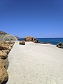
Gallery[]

Passage view of Għajn Barrani
Flat terrain in Għajn Barrani

Landscape in Għajn Barrani


See also[]
References[]
- ^ "N2K MT0000001 dataforms". natura2000.eea.europa.eu. Retrieved 2021-04-30.
- ^ "Għajn Barrani". . Retrieved 2021-04-30.
{{cite web}}: CS1 maint: url-status (link) - ^ "5 Hidden Beaches In Gozo To Visit This Summer". Air Malta Blog. 2018-08-05. Retrieved 2021-05-02.
- ^ Collins, Nicola. "The Best Secret Beaches in Malta to Visit". Culture Trip. Retrieved 2021-05-02.
- ^ F. Attard, Anton (2015). "The Lore of Turkish Raids on Gozo" (PDF). University of Malta. Retrieved 2021-04-30.
{{cite web}}: CS1 maint: url-status (link) - ^ "Għajn Barrani (l/o Xagħra)". Times of Malta. Retrieved 2021-05-02.
{{cite web}}: CS1 maint: url-status (link) - ^ "Għajn Barrani area". Times of Malta. Retrieved 2021-05-02.
- ^ "Għajn Barrani area". Times of Malta. Retrieved 2021-05-02.
- ^ Mifsud, Stephen (2002-08-23). "Ononis oligophylla (Few-leaved Restharrow) : MaltaWildPlants.com - the online Flora of the Maltese Islands". www.maltawildplants.com. Retrieved 2021-05-02.
- ^ "N2K MT0000001 dataforms". natura2000.eea.europa.eu. Retrieved 2021-05-02.
- ^ "BioSnippet Issue 6" (PDF). ERA. 2019. Retrieved 2021-05-02.
{{cite web}}: CS1 maint: url-status (link) - ^ "N2K MT0000001 dataforms". natura2000.eea.europa.eu. Retrieved 2021-04-30.
- ^ Caruana Dingli, Petra; Galea, Martin (2016). "THE FUTURE OF NATURE PARKS IN MALTA" (PDF). Din l-Art Ħelwa. p. 43. Retrieved 2021-05-02.
{{cite web}}: CS1 maint: url-status (link) - ^ "Tree Protection Areas". ERA. Retrieved 2021-05-02.
{{cite web}}: CS1 maint: url-status (link)
Coordinates: 36°04′00″N 14°16′10″E / 36.06667°N 14.26944°E

This Malta location article is a stub. You can help Wikipedia by . |
- Geography of Malta
- Malta geography stubs