Garanhuns
Garanhuns | |
|---|---|
| Município de Garanhuns Municipality of Garanhuns | |
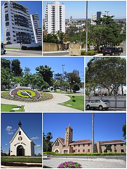 Top left: Heliopolis area Top right: Gonçalves Maia Street Middle left: Floral Clock (Relógio das Flores) Middle right: Dom Moura Square Bottom left: Mãe Rainha Sanctuary Bottom right: Saint Joseph Seminary (Seminário São José) | |
 Flag  Seal | |
| Nicknames: "Suíça pernambucana" ("Switzerland in Pernambuco"), "Cidade das flores" ("City of Flowers") | |
 | |
 Garanhuns Location in Brazil | |
| Coordinates: 08°53′25″S 36°29′34″W / 8.89028°S 36.49278°WCoordinates: 08°53′25″S 36°29′34″W / 8.89028°S 36.49278°W | |
| Country | |
| Region | Northeast |
| State | |
| Founded | 1879 |
| Government | |
| • Mayor | Izaías Régis Neto {PTB} |
| Area | |
| • Total | 472.462 km2 (182.419 sq mi) |
| Elevation | 896 m (2,940 ft) |
| Population (2020 [1]) | |
| • Total | 140,577 |
| • Density | 275.8/km2 (714/sq mi) |
| Demonym(s) | garanhuense |
| Time zone | UTC−3 (BRT) |
| • Summer (DST) | UTC−2 (BRST) |


Garanhuns is a city in the Brazilian state of Pernambuco. Located in the Borborema Plateau, the town is known as the "Suíça Pernambucana" (Pernambucan Switzerland) due to its elevation and relatively cool climate. It is also known as "Cidade das Flores" ("City of Flowers") or "Cidade da Garoa" ("City of Drizzle").
Garanhuns is most famous for the Festival de Inverno, or The Winter Festival, which it holds every year in July. During the winter, temperatures in Garanhuns can drop to 7 degrees Celsius (45 degrees Fahrenheit). This is quite cold for a city that is only a few degrees south of the equator.
Garañun (Garanhun) was an extinct, undocumented language once spoken by an indigenous tribe in the Serra dos Garanhuns.[2]
Geography[]
- Region - Agreste of Pernambuco
- Boundaries - Capoeiras and Jucati (N); Lagoa do Ouro and Correntes (S); São João and Palmeirina (E); Caetés, Saloa, Paranatama, Brejão and Terezinha (W)
- Area - 472.5 km2
- Elevation - 842 m
- Hydrography - Mundaú River
- Vegetation - Evergreen forest
- Climate - Mesothermal
- Annual average temperature - 20.4 °C
- Main road - BR 101, PE 126 and PE 177
- Distance to Recife - 223 km
Climate[]
The climate of Garanhuns is classified as tropical wet and dry, Köppen climate classification type As, with a dry summer and humid winter. Temperatures are mild for a tropical climate due to the altitude. The annual mean temperature is 21.1 °C (70.0 °F) and annual precipitation is 918 mm (36.1 in), with high humidity throughout the year. Annual sunshine averages 2330 hours.
Since 1961, the lowest temperature recorded was 10.0 °C (50.0 °F) in September 1978 and the highest was 34.5 °C (94.1 °F) in January 1995 and December 2002.
| hideClimate data for Garanhuns, Pernambuco, 1981-2010 normals, extremes 1961-present | |||||||||||||
|---|---|---|---|---|---|---|---|---|---|---|---|---|---|
| Month | Jan | Feb | Mar | Apr | May | Jun | Jul | Aug | Sep | Oct | Nov | Dec | Year |
| Record high °C (°F) | 34.5 (94.1) |
33.9 (93.0) |
33.1 (91.6) |
33.1 (91.6) |
31.5 (88.7) |
29.0 (84.2) |
29.5 (85.1) |
29.7 (85.5) |
31.9 (89.4) |
33.3 (91.9) |
33.3 (91.9) |
34.5 (94.1) |
34.5 (94.1) |
| Average high °C (°F) | 29.0 (84.2) |
28.7 (83.7) |
28.5 (83.3) |
26.8 (80.2) |
25.2 (77.4) |
23.4 (74.1) |
22.6 (72.7) |
23.1 (73.6) |
24.9 (76.8) |
27.2 (81.0) |
28.7 (83.7) |
29.1 (84.4) |
26.4 (79.6) |
| Daily mean °C (°F) | 22.5 (72.5) |
22.5 (72.5) |
22.7 (72.9) |
21.9 (71.4) |
21.1 (70.0) |
19.6 (67.3) |
18.7 (65.7) |
18.7 (65.7) |
19.6 (67.3) |
21.1 (70.0) |
22.0 (71.6) |
22.5 (72.5) |
21.1 (70.0) |
| Average low °C (°F) | 18.4 (65.1) |
18.6 (65.5) |
19.0 (66.2) |
18.8 (65.8) |
18.1 (64.6) |
17.2 (63.0) |
16.4 (61.5) |
16.1 (61.0) |
16.5 (61.7) |
17.2 (63.0) |
17.8 (64.0) |
18.2 (64.8) |
17.7 (63.9) |
| Record low °C (°F) | 15.4 (59.7) |
15.4 (59.7) |
11.8 (53.2) |
15.0 (59.0) |
14.8 (58.6) |
10.5 (50.9) |
11.7 (53.1) |
10.9 (51.6) |
10.0 (50.0) |
11.4 (52.5) |
12.8 (55.0) |
14.9 (58.8) |
10.0 (50.0) |
| Average precipitation mm (inches) | 40.1 (1.58) |
46.1 (1.81) |
92.2 (3.63) |
101.4 (3.99) |
113.2 (4.46) |
161.7 (6.37) |
141.1 (5.56) |
102.2 (4.02) |
50.0 (1.97) |
20.1 (0.79) |
17.1 (0.67) |
33.1 (1.30) |
918.3 (36.15) |
| Average precipitation days (≥ 1 mm) | 5 | 5 | 7 | 11 | 14 | 18 | 20 | 16 | 9 | 3 | 2 | 3 | 113 |
| Average relative humidity (%) | 75.3 | 77.7 | 78.8 | 83.8 | 87.9 | 90.7 | 91.4 | 89.6 | 85.8 | 78.7 | 74.3 | 73.6 | 82.3 |
| Mean monthly sunshine hours | 221.5 | 201.1 | 209.5 | 185.5 | 162.0 | 124.6 | 125.9 | 152.6 | 193.9 | 239.5 | 258.3 | 255.6 | 2,330 |
| Source: Instituto Nacional de Meteorologia (INMET)[3] | |||||||||||||
Tourism[]
It's the weather, cold for the locals and mild for foreigners, and the mountains which attract many tourists to the region during Summer and Winter. Garanhuns, Gravatá and Triunfo are the most visited mountainous (cold) cities of the state. The city is served by Garanhuns Airport.
Tourist attractions

- Winter musical festival (July)
- Flowers clock Relógio das flores
- Celso Galvao Palace
- Park Euclides Dourado and Park Ruben Van Der Linden
- João Capão Castle
- São Bento Monastery
- Ipiranga Monument
- The seven Hills.
Economy[]

The main economic activities in Garanhuns are based in mountain tourism (winter tourism), general commerce and primary sector especially flowers, tomatoes, manioc, cows, chickens and milk.
Economic indicators[]
| Population [4] | GDP x(1000 R$).[5] | GDP pc (R$) | PE |
|---|---|---|---|
| 131.313 | 742.593 | 5.941 | 1.20% |
Economy by Sector 2006
| Primary sector | Secondary sector | Service sector |
|---|---|---|
| 3.75% | 21.50% | 74.75% |
Health indicators[]
| HDI (2000) | Hospitals (2007) | Hospital beds (2007) | Children's Mortality per 1000 (2005) |
|---|---|---|---|
| 0.693 | 5 | 488 | 23.1 |
Notable residents[]
Garanhuns is notable for being the hometown of President Luiz Inácio Lula da Silva, born in Caetés, which was a district of Garanhuns until 1963. The film Lula, o filho do Brasil, about his life, was shot at the town.
The composer and musician Dominguinhos was also born in the city, as well as the actress , well known for her work in both TV and stage.
See also[]
References[]
| Wikimedia Commons has media related to Garanhuns. |
- ^ IBGE 2020
- ^ Loukotka, Čestmír (1968). Classification of South American Indian languages. Los Angeles: UCLA Latin American Center.
- ^ "Normais Climatológicas do Brasil". Instituto Nacional de Meteorologia. Retrieved February 25, 2021.
- ^ http://www.ibge.gov.br/home/estatistica/populacao/estimativa2009/POP2009_DOU.pdf IBGE Population 2009 Garanhuns, page 33
- ^ Garanhuns 2006 GDP IBGE pág 30 Archived October 3, 2011, at the Wayback Machine
- ^ PE State site - City by city profile
| hide | ||||||||||||||
|---|---|---|---|---|---|---|---|---|---|---|---|---|---|---|
Capital: Recife | ||||||||||||||
| Mesoregion Agreste Pernambucano |
|  | ||||||||||||
| Mesoregion Mata Pernambucana |
| |||||||||||||
| Mesoregion Metropolitana de Recife |
| |||||||||||||
| Mesoregion Sao Francisco Pernambucano |
| |||||||||||||
| Mesoregion Sertao Pernambucano |
| |||||||||||||
| show Authority control |
|---|
- Municipalities in Pernambuco
- Winter festivals