Garw Valley
Garw Valley
| |
|---|---|
 Location of Garw Valley within Bridgend County Borough | |
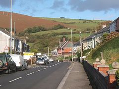 A4064 road running through Llangeinor | |
| Population | 7,784 (2011) [1] |
| Principal area | |
| Ceremonial county | |
| Country | Wales |
| Sovereign state | United Kingdom |
| Post town | BRIDGEND |
| Postcode district | CF32 |
| Dialling code | 01656 |
| Ambulance | Welsh |
| UK Parliament | |
| Senedd Cymru – Welsh Parliament |
|
Garw Valley (Welsh: Cwm Garw) is a community in the north of Bridgend County Borough, South Wales. As the name suggests, it follows and encompasses the valley of the River Garw. The community includes the village of Blaengarw at the head of the valley, followed by Pontycymer and Llangeinor on the river, with Bettws between the Garw and the Llynfi in the south.[2] Garw Valley is bordered to the west by Maesteg, Llangynwyd Middle and Llangynwyd Lower; to the east by Ogmore Valley and to the south by Ynysawdre and St Bride's Minor.[2]
Attractions include the Garw Valley Railway, a four and half mile narrow gauge steam railway, which volunteers began re-laying in 2016. Passenger rail services had previously ceased in the valley in 1991.[3]
Governance[]
At the local level, Garw Valley elects 13 community councillors to Garw Valley Community Council, from the four wards of Bettws, Llangeinor, Pontycymmer and Blaengarw.[4]
At the county level, the community is covered by four electoral wards, of Blaengarw, Pontycymmer, Llangeinor and Bettws,[2] each electing one county councillor to Bridgend County Borough Council.[5]
References[]
- ^ "Garw Valley - Community in Wales". citypopulation.de. Retrieved 12 April 2019.
- ^ a b c "Election maps". Ordnance Survey. Retrieved 12 April 2019.
- ^ Abby Bolter (25 February 2016). "The plan to bring steam trains back to the Garw Valley should take a big step forward this year". Wales Online. Retrieved 12 April 2019.
- ^ "Welcome to the Garw Valley Community Council". Garw Valley Community Council. Retrieved 12 April 2019.
- ^ "The County Borough of Bridgend (Electoral Arrangements) Order 1998". legislation.gov.uk. The National Archives. 23 November 1998. Retrieved 12 April 2019.
External links[]
| Communities |  | |
|---|---|---|
| Towns and villages |
| |
| Castles | ||
| Rivers | ||
| Topics | ||

- Communities in Bridgend County Borough
- Valleys of Bridgend County Borough