Gearhart Mountain
| Gearhart Mountain | |
|---|---|
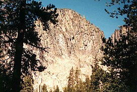 Gearhart Mountain viewed from wilderness trail | |
| Highest point | |
| Elevation | 8,041 ft (2,451 m)[1] |
| Prominence | 3,430 ft (1,050 m)[2] |
| Parent peak | Drake Peak |
| Isolation | 40.85 mi (65.74 km)[2] |
| Coordinates | 42°29′00″N 120°51′35″W / 42.48333°N 120.85972°WCoordinates: 42°29′00″N 120°51′35″W / 42.48333°N 120.85972°W[1] |
| Geography | |
 Gearhart Mountain Location in the state of Oregon | |
| Location | Lake County and Klamath County, Oregon |

Gearhart Mountain is a 8,041-foot (2,451 m) high mountain in Lake County and Klamath County, Oregon, in the United States. It is located in the Gearhart Mountain Wilderness of the Fremont–Winema National Forest, northeast of the Sprague River valley and the town of Bly.
See also[]
References[]
- ^ a b U.S. Geological Survey Geographic Names Information System: Gearhart Mountain
- ^ a b Gearhart Mountain at Peakbagger.com
This Klamath County, Oregon state location article is a stub. You can help Wikipedia by . |
This Lake County, Oregon state location article is a stub. You can help Wikipedia by . |
Categories:
- Klamath County, Oregon geography stubs
- Oregon geography stubs
- Mountains of Klamath County, Oregon
- Mountains of Lake County, Oregon
- North American 2000 m summits