Gentofte Municipality
Gentofte Municipality | |
|---|---|
 | |
 Coat of arms | |
 | |
| Coordinates: 55°45′02″N 12°33′07″E / 55.750472°N 12.552073°ECoordinates: 55°45′02″N 12°33′07″E / 55.750472°N 12.552073°E | |
| Country | Denmark |
| Region | Hovedstade |
| Seat | Charlottenlund |
| Government | |
| • Mayor | (C) |
| Area | |
| • Total | 25.54 km2 (9.86 sq mi) |
| Population (1 April 2014) | |
| • Total | 74,548 |
| • Density | 2,900/km2 (7,600/sq mi) |
| Time zone | UTC+1 (CET) |
| • Summer (DST) | UTC+2 (CEST) |
| Municipal code | 157 |
| Website | www |

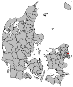
Gentofte Kommune is a municipality (Danish, kommune) in the Capital Region of Denmark (Region Hovedstaden) on the east coast of the island of Zealand (Sjælland) in eastern Denmark. It covers an area of 25.54 km2 (9.86 sq mi), and has a total population of 74,548 (1 April 2014). Since 1993, its mayor has been , a member of the Conservative People's Party (Det Konservative Folkeparti).
The municipality is an amalgamation of three formerly independent towns, and several other local settlements, all close to one another. The site of its municipal council is in Charlottenlund. The three original towns were Gentofte, Vangede and Ordrup. It later included Tuborg, Skovshoved, Dyssegård, Hellerup, Jægersborg, and Klampenborg.
Neighboring municipalities are Lyngby-Taarbæk to the north, Gladsaxe to the west, and Copenhagen to the south. The Øresund, the strait that separates Zealand from Sweden, is to the east.
Gentofte municipality was not merged with other municipalities in the 1 January 2007 nationwide Kommunalreformen.
Lars Ulrich was born in Gentofte.
Demography[]
|
| |||||||||||||||||||||||||||||||||||||||||||||||||||||||||||||||||||||
| Note: 1769's count refers to 15 January 1769; 1787's count refers to 1 July 1787. Source:[citation needed] | ||||||||||||||||||||||||||||||||||||||||||||||||||||||||||||||||||||||
Politics[]
Municipal council[]
Gentofte's municipal council consists of 19 members, elected every four years.
Below are the municipal councils elected since the Municipal Reform of 2007.
| Election | Party | Total seats |
Turnout | Elected mayor | |||||||||
|---|---|---|---|---|---|---|---|---|---|---|---|---|---|
| A | B | C | F | I | T | V | Ø | ||||||
| 2005 | 2 | 2 | 9 | 1 | 1 | 2 | 17 | 68.8% | Hans Toft (C) | ||||
| 2009 | 3 | 2 | 10 | 2 | 2 | 19 | 66.3% | ||||||
| 2013 | 3 | 1 | 11 | 1 | 2 | 1 | 72.4% | ||||||
| 2017 | 2 | 1 | 13 | 1 | 1 | 1 | 71.6% | ||||||
| Data from Kmdvalg.dk 2005, 2009, 2013 and 2017 | |||||||||||||
Attractions[]
- Bellavista housing estate and Bellevue Teatret designed by Arne Jacobsen
- Bernstorff Palace
- Charlottenlund palace, park and forest
- Ordrupgaard – art museum, French impressionists, Paul Gauguin, Danish paintings from around 1900, varying special exhibitions.
- Gentofte Sportspark – football stadium, home stadium of Hellerup IK
- Kildeskovshallen- swimming pool (including a 50m pool, 25m pool, a children's pool, a baby pool with warm water basin, and also Finnish saunas), including also other facilities such as two halls for ball game, a physiotherapist clinique, fitness centre, conference rooms, and a restaurant.
- Øregård Museum
Education[]
Gentofte Municipality is home to four public upper secondary schools: Øregård and in Hellerup, in Gentofte and in Ordrup. Gentofte Municipality is also home to the private Rygaards International School and Copenhagen International School, although the latter are going to relocate to new premises that are under construction in the Nordhavn district of Copenhagen. Gentofte Studenterkursus offers a two-year programme.
Parks and open spaces[]

The most important parks are Charlottenlund Beach Park, , Bernstorff Park.
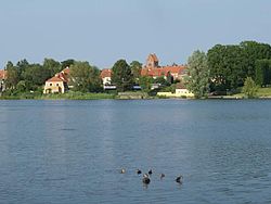
Natural habitats are found at , a huge lake with many birds on it, Ermelunden in Jægersborg and Gammelmose in Vangede, (or Øregård Museum's Garden) with a beautiful lake, benches and also a playground. A small section of Jægersborg Dyrehave also extends into the municipality, while the rest, including the Dyrehavsbakken fun fair, is in Lyngby-Taarbæk.
Twin towns – sister cities[]
 Halmstad, Sweden
 Hanko, Finland
 Sermersooq, Greenland
 Stord, Norway
See also[]
- Gentofte station
- Gentofte Hospital
- Steno Diabetes Center
- Kildeskovshallen
- Gentofte Town Hall
- Gentofte#Notable people
References[]
- ^ "Venskabsbyer". gentofte.dk (in Danish). Gentofte Kommune. Retrieved 15 April 2021.
- Municipal statistics: NetBorger Kommunefakta, delivered from KMD aka Kommunedata (Municipal Data)
- Municipal mergers and neighbors: Eniro new municipalities map
- Demography:(in Danish) Statistical Yearbook of Copenhagen. ISBN 87-7024-230-5
External links[]
| Wikimedia Commons has media related to Gentofte Kommune. |
| show Places adjacent to Gentofte Municipality |
|---|
| show Authority control |
|---|
- Gentofte Municipality
- Municipalities in the Capital Region of Denmark
- Municipalities of Denmark
- Copenhagen metropolitan area