Geograph Channel Islands
 Geograph Channel Islands is a web-based project, initiated in April 2010,[1] to create a freely accessible archive of geographically located photographs of the Channel Islands.[2]
Photographs in the Geograph Channel Islands collection are chosen to illustrate geographical features all parts of the Channel Islands. It is an offshoot of Geograph Britain and Ireland which began in March 2008.[3]
Geograph Channel Islands is a web-based project, initiated in April 2010,[1] to create a freely accessible archive of geographically located photographs of the Channel Islands.[2]
Photographs in the Geograph Channel Islands collection are chosen to illustrate geographical features all parts of the Channel Islands. It is an offshoot of Geograph Britain and Ireland which began in March 2008.[3]
A few examples of images on the site;
Fermain Bay, taken by Derek Harper on 1 May 1999

Hotel L'Emeraude, St Helier taken by DS Pugh on 14 August 2001

Commercial Buildings, St Helier, taken by Colin Park on 20 July 2005

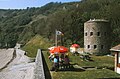
Noirmont Tower, taken by Bob Embleton on 12 August 2009
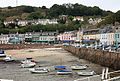
Gorey Harbour, taken by Bob Embleton on 12 August 2009


References[]
This Channel Islands article is a stub. You can help Wikipedia by . |
- Geography of the Channel Islands
- British digital libraries
- Image sharing websites
- Photo archives in the United Kingdom
- Outdoor locating games
- Channel Islands stubs