George Street, Richmond
 George Street in 1988 | |||
| Location | Richmond, London, England, United Kingdom | ||
| Postal code | TW10 | ||
| Nearest National Rail, London Overground, London Underground station | Richmond railway station | ||
| Other | |||
| Known for | It was one of the first streets to be developed in Richmond and is the town's high street | ||
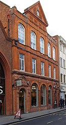
George Street, at the confluence of the A305 and A307 roads, is the high street in Richmond, London and was one of the first streets to be developed in the town.[1] Previously known as Great Street,[2] it was renamed after King George III in 1769.[1] Buildings on the street include the Grade II listed Greyhound House, formerly the Greyhound Hotel,[3] in a building dating from the 1730s.[2] The facade of the former General Post Office building at 70–72 George Street, now a retail store, incorporates the coat of arms of the former Municipal Borough of Richmond, which existed from 1890 to 1965.
The street is one-way eastbound. Westbound traffic uses Eton Street, Paradise Road and Red Lion Street.
Memorial plaque[]
At Barclays Bank a memorial plaque, relocated in 2014 from the bank's former branch in Ham,[4] commemorates Angela Woolliscroft, a bank teller who was murdered in 1976 during a bank robbery at the Ham branch. It reads: "In fond memory of Angela Woolliscroft who died on 10th November 1976. A member of staff of this branch who will always be remembered by her colleagues."
Gallery[]
Former Post Office building on George Street

Facade of the Post Office building, showing the coat of arms of the former Municipal Borough of Richmond
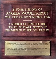
Memorial plaque paying tribute to bank teller Angela Woolliscroft, murdered in 1976 during a robbery at Barclays Bank's branch in Ham

References[]
- ^ a b The Streets of Richmond and Kew (Third ed.). Richmond Local History Society. 2019. p. 46.
- ^ a b "Riverside – south of the river, west of the Tower. Richmond – central and riverside". Edith's Streets. 14 June 2016. Retrieved 19 October 2019.
- ^ Historic England (10 January 1950). "Greyhound House (1080824)". National Heritage List for England. Retrieved 15 July 2020.
- ^ Dyduch, Amy (24 April 2014). "Murdered Chessington teller's memory to be honoured when bank moves out of Ham Parade". Richmond and Twickenham Times. Retrieved 30 June 2020.
| Wikimedia Commons has media related to George Street, Richmond. |
Further reading[]
- The Streets of Richmond and Kew (Third ed.). Richmond Local History Society. 2019. 140 pages. ISBN 978-1912-314010.
External links[]
Coordinates: 51°27′37.44″N 0°18��18.72″W / 51.4604000°N 0.3052000°W


- George Street, Richmond
- Barclays
- High Streets
- Richmond, London
- Shopping streets in London
- Streets in the London Borough of Richmond upon Thames