Gergovie plateau
This article does not cite any sources. (May 2011) |

The Gergovie plateau is a plateau of the Massif Central located 10 km to the south of Clermont-Ferrand, Puy-de-Dôme, Auvergne, France and is named after the nearby village of Gergovie. It is the site of the Battle of Gergovia between Vercingetorix and Julius Caesar in 52 BC.
Location[]
The plateau is located at 744 meters above sea level, and from it can be seen Chaîne des Puys, Clermont-Ferrand, and the Plaine des Sarlièves (Plain of Sarlièves), along with the Zénith d'Auvergne and the Puy de Sancy which dominates the Auvergne from it position 1886m above sea level.
Attractions[]
A reconstructed "Gallic hut", with an accompanying permanent exhibition ("La Maison de Gergovie") can be seen on the plateau.
Events[]
Cervolix[]
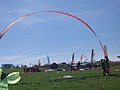
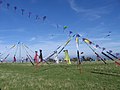
"Cervolix" - an association of kite fliers and kite surfers on the plateau. It is also used, since 1995, by remote-controlled aircraft fliers.

Cervolix 2006
Cervolix 2006
Cervolix 2006

Cervolix 2006


Les Arverniales[]
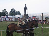
"Les Arverniales" is an archaeological festival held on the plateau, consisting of two days of reconstructions, experimental archeology and living history displays.
Exhibitions[]
Sculptures by have also been displayed on the plateau since January 2007.
See also[]
External links[]

- Plateaus of Metropolitan France
- Landforms of Puy-de-Dôme
- Landforms of Auvergne-Rhône-Alpes