Gipping Rural District
| Gipping | |
|---|---|
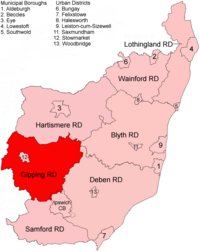 Location within East Suffolk, 1934 | |
| History | |
| • Created | 1934 |
| • Abolished | 1974 |
| • Succeeded by | Mid Suffolk District |
| Status | Rural district |
| • HQ | Needham Market |
Gipping Rural District was a rural district in the county of East Suffolk, England. It was created in 1934 by the merger of the disbanded Bosmere and Claydon Rural District and the disbanded East Stow Rural District, under a County Review Order.[1] It was named after the River Gipping and administered from Needham Market.
Its area was reduced slightly in 1952 by an expansion of the county borough of Ipswich.
On 1 April 1974 it was abolished under the Local Government Act 1972, and has since formed part of the District of Mid Suffolk.
Statistics[]
| Year | Area[2] | Population [3] |
Density (pop/ha) | |
|---|---|---|---|---|
| acres | ha | |||
| 1951 | 78,913 | 31,935 | 20,515 | 0.64 |
| 1961 | 78,464 | 31,754 | 19,314 | 0.61 |
Parishes[]
At the time of its dissolution it consisted of the following 49 civil parishes.
- Akenham
- Ashbocking
- Ashfield cum Thorpe
- Badley
- Barnham
- Barking
- Battisford
- Baylham
- Blakenham Magna
- Blakenham Parva
- Bramford
- Bricett Magna
- Buxhall
- Claydon
- Coddenham
- Combs
- Creeting St Mary
- Creeting St Peter
- Crowfield
- Debenham
- Finborough Magna
- Finborough Parva
- Flowton
- Framsden
- Gipping
- Gosbeck
- Harleston
- Haughley
- Helmingham
- Hemingstone
- Henley
- Mickfield
- Needham Market
- Nettlestead
- Offton
- Old Newton
- Onehouse
- Pettaugh
- Ringshall
- Shelland
- Somersham
- Stonham Aspal
- Stonham Earl
- Stonham Parva
- Stowupland
- Wetherden
- Whitton
- Willisham
- Winston
References[]
- ^ "Giping RD through time: Census tables with data for the Local Government District". A Vision of Britain through Time. GB Historical GIS / University of Portsmouth. Retrieved 10 Jul 2017.
- ^ "Giping RD through time: Population Statistics: Area (acres)". A Vision of Britain through Time. GB Historical GIS / University of Portsmouth. Retrieved 10 Jul 2017.
- ^ "Giping RD through time: Population Statistics: Total Population". A Vision of Britain through Time. GB Historical GIS / University of Portsmouth. Retrieved 10 Jul 2017.
Coordinates: 52°08′N 0°58′E / 52.14°N 0.97°E

| Pre-1974 |
| ||||||
|---|---|---|---|---|---|---|---|
| Post-1974 | |||||||
Categories:
- History of Suffolk
- Districts of England abolished by the Local Government Act 1972