Glenduan
Glenduan | |
|---|---|
Town | |
 Glenduan | |
 | |
| Coordinates: 41°11′10″S 173°21′50″E / 41.18611°S 173.36389°ECoordinates: 41°11′10″S 173°21′50″E / 41.18611°S 173.36389°E | |
| Country | New Zealand |
| Region | Nelson |

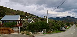
Glenduan is a small township lying to the north of Nelson, New Zealand. It lies on the shore of Tasman Bay / Te Tai-o-Aorere between the northern end of Boulder Bank and Pepin Island.[1][2]
The settlement's main park, Glenduan Reserve, is a public beach and local park.[3]
Horoirangi Marine Reserve is located offshore of Glenduan.[4]
Demographics[]
The population was 477 in the 2013 census. This was an increase of 27 people since the 2006 Census.[5]
Glenduan is part of the Nelson Rural statistical area.[6]
References[]
- ^ Reed New Zealand atlas (2004) Auckland: Reed Publishing. Map 59. ISBN 0 7900 0952 8
- ^ Wise's Nelson-Blenheim "Easyread" Map ISBN 1 877402 50 8
- ^ "Nelson Parks and Reserves". gdc.govt.nz. Gisborne District Council.
- ^ "DOC Places to Go - Nelson-Tasman". doc.govt.nz. Department of Conservation.
- ^ 2013 Census QuickStats about a place : Glenduan
- ^ 2018 Census place summary: Nelson Rural
This article related to the geography of Nelson, New Zealand is a stub. You can help Wikipedia by . |
Categories:
- Populated places in the Nelson Region
- Populated places around Tasman Bay / Te Tai-o-Aorere
- Nelson, New Zealand geography stubs