Gołąb, Puławy County
Gołąb | |
|---|---|
Village | |
 | |
 Gołąb | |
| Coordinates: 51°29′13″N 21°52′31″E / 51.48694°N 21.87528°E | |
| Country | |
| Voivodeship | Lublin |
| County | Puławy |
| Gmina | Gmina Puławy |
| Elevation | 115 m (377 ft) |
| Population | 2,227[1] |


Gołąb [ˈɡɔwɔmp] is a village in the administrative district of Gmina Puławy, within Puławy County, Lublin Voivodeship, in eastern Poland. It lies approximately 11 kilometres (7 mi) north-west of Puławy and 56 km (35 mi) north-west of the regional capital Lublin.[2]
As of 2011, the population of the village is 2227.
Gołąb means "pigeon" in Polish.
Monuments[]
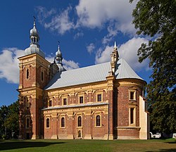
- Saints Catherine and Florian Church
- Loreto House
- A figure of John of Nepomuk
- Museum of Unusual Bicycles.
History[]
The first historical mention of the town was in the XII century. The parish church was constructed between 1628–1636, and the Loreto House was constructed between 1634 and 1638.
An invading Swedish army routed a Polish army in the Battle of Gołąb 1656.
The Gołąbska Confederation was found on the 16 October, 1672.
In 1939, Germans bombed the airport and a nearby lake. A dozen or so women who were washing clothes and bedding by the lake, were mistakenly recognised by paratroopers and died.
References[]
- ^ "Wieś Gołąb (lubelskie) » mapy, GUS, nieruchomości, szkoły, regon, atrakcje, kod pocztowy, kierunkowy, edukacja, przedszkola, demografia, zabytki, statystyki, tabele, linie kolejowe". Polska w liczbach (in Polish). Retrieved 12 March 2019.
- ^ "Central Statistical Office (GUS) - TERYT (National Register of Territorial Land Apportionment Journal)" (in Polish). 2008-06-01.
| Seat (not part of the gmina) |  | |
|---|---|---|
| Villages | ||
Coordinates: 51°29′13″N 21°52′31″E / 51.48694°N 21.87528°E
This Puławy County location article is a stub. You can help Wikipedia by . |
- Villages in Puławy County
- Puławy County geography stubs