Grafengehaig
This article needs additional citations for verification. (March 2007) |
Grafengehaig | |
|---|---|
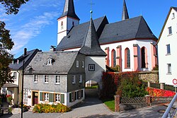 Fortified church of the Holy Spirit in Grafengehaig | |
 Coat of arms | |
show Location of Grafengehaig within Kulmbach district | |
 Grafengehaig | |
| Coordinates: 50°12′N 11°34′E / 50.200°N 11.567°ECoordinates: 50°12′N 11°34′E / 50.200°N 11.567°E | |
| Country | Germany |
| State | Bavaria |
| Admin. region | Oberfranken |
| District | Kulmbach |
| Municipal assoc. | Marktleugast |
| Subdivisions | 27 Ortsteile |
| Government | |
| • Mayor (2020–26) | Werner Burger[1] |
| Area | |
| • Total | 20.80 km2 (8.03 sq mi) |
| Elevation | 568 m (1,864 ft) |
| Population (2020-12-31)[2] | |
| • Total | 865 |
| • Density | 42/km2 (110/sq mi) |
| Time zone | UTC+01:00 (CET) |
| • Summer (DST) | UTC+02:00 (CEST) |
| Postal codes | 95356 |
| Dialling codes | 09255 |
| Vehicle registration | KU |
| Website | https://www.grafengehaig.de/ |


Grafengehaig is a municipality in the district of Kulmbach in Bavaria in Germany.
It is a part of the Franconian Forest nature park.
City arrangement[]
Grafengehaig is arranged in the following boroughs:
|
|
References[]
- ^ Liste der ersten Bürgermeister/Oberbürgermeister in kreisangehörigen Gemeinden, Bayerisches Landesamt für Statistik, 15 July 2021.
- ^ "Tabellenblatt "Daten 2", Statistischer Bericht A1200C 202041 Einwohnerzahlen der Gemeinden, Kreise und Regierungsbezirke". Bayerisches Landesamt für Statistik (in German). June 2021.
| Wikimedia Commons has media related to Grafengehaig. |
| show Towns and municipalities in Kulmbach (district) |
|---|
| Authority control |
|---|
This Kulmbach district location article is a stub. You can help Wikipedia by . |
Categories:
- Municipalities in Bavaria
- Kulmbach (district)
- Upper Franconia geography stubs