Grafling
show This article may be expanded with text translated from the corresponding article in German. (March 2009) Click [show] for important translation instructions. |
Grafling | |
|---|---|
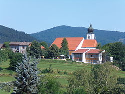 Saint Andrew Church | |
 Coat of arms | |
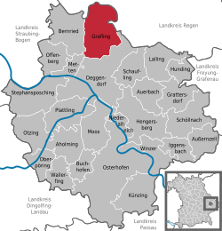
show Location of Grafling within Deggendorf district | |
 Grafling | |
| Coordinates: 48°54′N 12°59′E / 48.900°N 12.983°ECoordinates: 48°54′N 12°59′E / 48.900°N 12.983°E | |
| Country | Germany |
| State | Bavaria |
| Admin. region | Niederbayern |
| District | Deggendorf |
| Government | |
| • Mayor (2020–26) | Anton Stettmer[1] (CSU) |
| Area | |
| • Total | 46.28 km2 (17.87 sq mi) |
| Elevation | 433 m (1,421 ft) |
| Population (2020-12-31)[2] | |
| • Total | 2,772 |
| • Density | 60/km2 (160/sq mi) |
| Time zone | UTC+01:00 (CET) |
| • Summer (DST) | UTC+02:00 (CEST) |
| Postal codes | 94539 |
| Dialling codes | 0991 |
| Vehicle registration | DEG |
| Website | www.grafling.de |


Grafling is a municipality in the district of Deggendorf in Bavaria in Germany.
Geography[]
Grafling lies in the Danube Forest Planning Region (Planungsregion Donau-Wald). Its lowest point is in Großtiefenbach at 326 m above sea level (NN). The highest points of the municipality are the Steinberg (999 m), the Geißriegel (1,043 m), the Dreitannenriegel (1,090 m) and the Einödriegel (1,121 m) which rise above the valley of the Graflinger Tal to the east. To the north the valley ends at the Hochberg (727 m), to the west it is guarded by the Butzen (775 m) and the Vogelsang (1,022 m) in the municipality of Bernried. To the south the valley opens up towards Deggendorf, the Danube Plain, and the Gäuboden.
References[]
- ^ Liste der ersten Bürgermeister/Oberbürgermeister in kreisangehörigen Gemeinden, Bayerisches Landesamt für Statistik, 15 July 2021.
- ^ "Tabellenblatt "Daten 2", Statistischer Bericht A1200C 202041 Einwohnerzahlen der Gemeinden, Kreise und Regierungsbezirke". Bayerisches Landesamt für Statistik (in German). June 2021.
| show Towns and municipalities in Deggendorf (district) |
|---|
| Authority control |
|---|
This Deggendorf district location article is a stub. You can help Wikipedia by . |
- Municipalities in Bavaria
- Deggendorf (district)
- Lower Bavaria geography stubs