Graskop
Graskop | |
|---|---|
 Shops along the main street of Graskop | |
 Graskop | |
| Coordinates: 24°55′54″S 30°50′30″E / 24.93167°S 30.84167°ECoordinates: 24°55′54″S 30°50′30″E / 24.93167°S 30.84167°E | |
| Country | South Africa |
| Province | Mpumalanga |
| District | Ehlanzeni |
| Municipality | Thaba Chweu |
| Area | |
| • Total | 35.01 km2 (13.52 sq mi) |
| Elevation | 1,436 m (4,711 ft) |
| Population (2011)[1] | |
| • Total | 3,996 |
| • Density | 110/km2 (300/sq mi) |
| Racial makeup (2011) | |
| • Black African | 61.2% |
| • Coloured | 13.0% |
| • Indian/Asian | 0.9% |
| • White | 22.9% |
| • Other | 2.0% |
| First languages (2011) | |
| • Afrikaans | 29.4% |
| • Northern Sotho | 22.0% |
| • Sotho | 14.8% |
| • English | 10.9% |
| • Other | 22.8% |
| Time zone | UTC+2 (SAST) |
| Postal code (street) | 1270 |
| PO box | 1270 |
| Area code | 013 |


Graskop is a small town in Mpumalanga province, South Africa. It was set up in the 1880s as a gold mining camp but it now serves as a tourist destination and the timber industry. “God’s Window”, a scenic view from the escarpment of the Lowveld below, is located outside the town.
Graskop is 14 km south-east of Pilgrim's Rest and 28 km north of Sabie. It was laid out between 1880 and 1890 on a farm belonging to Abel Erasmus, Native Commissioner of the Transvaal Republic. The name is Afrikaans for grassy hillock. Originally it was a mining camp. It is the best place to view the "Edge of the Lowveld", with a sudden drop of 700 metres.[2]
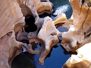
Potholes at Bourke's Luck near Graskop.
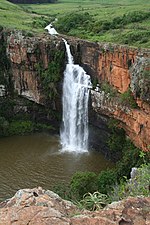
The Berlin Falls near Graskop.

"The Pinnacle" near Graskop.

"God's Window" near Graskop.


References[]
- ^ Jump up to: a b c d "Main Place Graskop". Census 2011.
- ^ "Dictionary of Southern African Place Names (Public Domain)". Human Science Research Council. p. 187.
External links[]
 Graskop travel guide from Wikivoyage
| hide Municipalities and communities of Ehlanzeni District Municipality, Mpumalanga | ||
|---|---|---|
District seat: Mbombela | ||
| Mbombela |  | |
| Nkomazi |
| |
| Thaba Chweu | ||
| Bushbuckridge |
| |
| Authority control |
|
|---|
This Mpumalanga location article is a stub. You can help Wikipedia by . |
- Populated places in the Thaba Chweu Local Municipality
- Mining communities in South Africa
- Mpumalanga geography stubs