Great Ditch
| Great Ditch | |
|---|---|
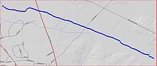 Great Ditch map | |
| Location | |
| Country | United States |
| Physical characteristics | |
| Source | |
| • coordinates | 40°23′5″N 74°28′57″W / 40.38472°N 74.48250°W |
| • elevation | 89 ft (27 m) |
| Mouth | |
• coordinates | 40°23′39″N 74°30′27″W / 40.39417°N 74.50750°WCoordinates: 40°23′39″N 74°30′27″W / 40.39417°N 74.50750°W |
| Basin features | |
| Progression | Lawrence Brook, Raritan River, Atlantic Ocean |
| River system | Raritan River system |

Great Ditch is a drainage ditch that drains areas of the Pigeon Swamp State Park in New Jersey in the United States.
Course[]
Great Ditch starts at 40°23′5″N 74°28′57″W / 40.38472°N 74.48250°W,[1] in the Pigeon Swamp State Park. It flows west, crossing Fresh Ponds Road and Route 130 before joining another stream at 40°23′39″N 74°30′27″W / 40.39417°N 74.50750°W[1] which drains into the Lawrence Brook.
Purpose[]
This canal's purpose is to drain sections of the Pigeon Swamp to prevent flooding of Deans Rhode Hall Road, which passes through the swamp.
Sister tributaries[]
- Beaverdam Brook
- Ireland Brook
- Oakeys Brook
- Sawmill Brook
- Sucker Brook
- Terhune Run
- Unnamed Brook in Rutgers Gardens, unofficially named Doc Brook
- Unnamed Brook in Rutgers' Helyar Woods
See also[]
References[]
- ^ a b "Great Ditch". Geographic Names Information System. United States Geological Survey. Retrieved 2010-07-24.
External links[]
Categories:
- Canals in New Jersey
- Tributaries of the Raritan River
- Bodies of water of Middlesex County, New Jersey