Great Smoky Mountains National Park
| Great Smoky Mountains National Park | |
|---|---|
 View from Mount Le Conte | |
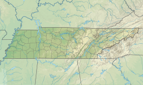 Location on the Tennessee and North Carolina border | |
| Location | Swain & Haywood counties in North Carolina; Sevier, Blount, & Cocke counties in Tennessee, United States |
| Nearest city | Cherokee, North Carolina, Townsend, Tennessee and Gatlinburg, Tennessee |
| Coordinates | 35°36′N 83°31′W / 35.600°N 83.517°WCoordinates: 35°36′N 83°31′W / 35.600°N 83.517°W[2] |
| Area | 522,419 acres (2,114.15 km2)[3] |
| Visitors | 12,095,720 (in 2020)[4] |
| Governing body | National Park Service |
| Website | Great Smoky Mountains National Park |
UNESCO World Heritage Site | |
| Criteria | Natural: vii, viii, ix, x |
| Reference | 259 |
| Inscription | 1983 (7th Session) |


Great Smoky Mountains National Park is an American national park in the southeastern United States, with parts in Tennessee and North Carolina. The park straddles the ridgeline of the Great Smoky Mountains, part of the Blue Ridge Mountains, which are a division of the larger Appalachian Mountain chain. The park contains some of the highest mountains in eastern North America, including Clingmans Dome, Mount Guyot, and Mount Le Conte. The border between the two states runs northeast to southwest through the center of the park. The Appalachian Trail passes through the center of the park on its route from Georgia to Maine. With 12.5 million visitors in 2019, the Great Smoky Mountains National Park is the most visited national park in the United States.[5]
| Map Highlighting the Park's Boundaries |
The park encompasses 522,419 acres (816.28 sq mi; 211,415.47 ha; 2,114.15 km2), making it one of the largest protected areas in the eastern United States.[3] The main park entrances are located along U.S. Highway 441 (Newfound Gap Road) in the towns of Gatlinburg, Tennessee and Cherokee, North Carolina, and also in Townsend, Tennessee. The park is internationally recognized for its mountains, waterfalls, biodiversity, and spruce-fir forests.[6] In addition, the park also preserves multiple historical structures that were part of communities occupied by early European-American settlers of the area.[7]
The park was chartered by the United States Congress in 1934, and officially dedicated by President Franklin D. Roosevelt in 1940. The Great Smoky Mountains was the first national park having land and other costs paid in part with federal funds; previous parks were funded wholly with state money or private funds.[8] The park was designated as a UNESCO World Heritage Site in 1983, and an International Biosphere Reserve in 1988.[9]
As the most visited national park in the United States, the Great Smoky Mountains National Park anchors a large tourism industry based in Sevier County, Tennessee adjacent to the park. Major attractions include Dollywood, the second-most visited tourist attraction in Tennessee, Ober Gatlinburg, and Ripley's Aquarium of the Smokies. Tourism to the park contributes an estimated $2.5 billion annually into the local economy.[10]
History[]
For thousands of years, this region was occupied by successive cultures of indigenous peoples. The historic Cherokee had their homeland here, and occupied numerous towns in the river valleys on both sides of the Appalachian Mountains. Their first encounters with Europeans were as traders, mostly coming from colonial Virginia and the Carolinas.
European Americans did not begin to settle here until the late 18th and early 19th centuries.[11] Particularly because of their pressure to acquire land in the Deep South, in 1830 President Andrew Jackson signed the Indian Removal Act, beginning the process that eventually resulted in the forced removal of all Indian tribes east of the Mississippi River to Indian Territory (now Oklahoma).
Most of the Cherokee were also removed. For a period some, led by such warriors as Tsali, evaded removal by staying in the area now part of the Great Smoky Mountains National Park. A band on the Oconaluftee River acquired land and also remained. Their descendants make up most of the federally recognized Eastern Band of Cherokee Indians, based in Cherokee, North Carolina, and their Qualla Boundary reserve to the south of the park.

As white settlers arrived, entrepreneurs developed logging as a major industry in the mountains. The Little River Railroad was constructed in the late-19th century to haul timber out of the remote regions of the area.
Because cut-and-run-style clearcutting was destroying the natural beauty of the area, by the 20th century visitors and locals banded together to raise money for preservation of the land. The U.S. National Park Service wanted a park in the eastern United States, but did not have much money to establish one. David Chapman, a Knoxville, Tennessee business leader, was appointed in 1925 to head a commission to establish a national park here. Congress authorized the park in 1926, but there was no nucleus of federally owned land around which to develop it. John D. Rockefeller, Jr. contributed $5 million, the U.S. government added $2 million, and private citizens from Tennessee and North Carolina pitched in to assemble the land for the park, piece by piece.
Slowly, mountain homesteaders, miners, and loggers were evicted from the land. Farms and timbering operations were abolished to establish the protected areas of the park. Travel writer Horace Kephart, for whom Mount Kephart was named, and photographers Jim Thompson and George Masa were instrumental in fostering the development of the park.[8][12] Former Governor Ben W. Hooper of Tennessee was the principal land purchasing agent for the park,[13] which was officially established on June 15, 1934. During the Great Depression, the Civilian Conservation Corps, the Works Progress Administration, and other federal organizations hired workers to build trails, fire watchtowers, and other infrastructure improvements to the park and Smoky Mountains.
Cultural importance[]
The park was used for filming scenes of Disney's hit 1950s TV series Davy Crockett, King of the Wild Frontier.
This park was designated an International Biosphere Reserve in 1976, was certified as a UNESCO World Heritage Site in 1983, and became a part of the Southern Appalachian Biosphere Reserve in 1988.[14]
A 75th anniversary re-dedication ceremony was held on 2 September 2009. Among those in attendance were the four U.S. senators from Tennessee and North Carolina, the three US Representatives whose districts include the park, the governors of both states, and Secretary of the Interior Ken Salazar. Dolly Parton, Tennessee native, singer, and actress also attended and performed.[15]
In late November and early December 2016, a series of wildfires engulfed a total of 17,900 acres (72 km2) in the park and surrounding areas. The wildfires killed at least 14, injured 190, and forced the evacuation of more than 14,000 people.[16] The fires also damaged or destroyed at least 2,000 structures. The fires, which were initially suspected to have been caused by arson, occurred during a period of unusual drought, which accelerated the fires. The wildfires were the deadliest in the Eastern United States since the Great Fires of 1947, and comprised one of the worst natural disasters in the history of Tennessee.[17][18][19][20]
In 2015 Cassius Cash was appointed as the first African-American superintendent of Great Smoky Mountains National Park. He is the 16th superintendent of the park.[21]
Geology[]
The majority of rocks in the Great Smoky Mountains National Park are Late Precambrian rocks that are part of the . This group consists of metamorphosed sandstones, phyllites, schists, and slate. Early Precambrian rocks are not only the oldest rocks in the park but also the dominant rock type in sites such as the Raven Fork Valley and upper Tuckasegee River between Cherokee and Bryson City. They primarily consist of metamorphic gneiss, granite, and schist. Cambrian sedimentary rocks can be found among the bottom of the Foothills to the northwest, and in limestone coves such as Cades Cove.[22] One of the most visited attractions in the mountains is Cades Cove, which is a window or an area where older rocks made out of sandstone surround the valley floor of younger rocks made out of limestone.
The oldest rocks in the Smokies are the Precambrian gneiss and schists which were formed over a billion years ago from the accumulation of marine sediments and igneous rock. In the Late Precambrian, the primordial ocean expanded and the more recent Ocoee Supergroup rocks formed from the accumulation of eroding land mass onto the continental shelf. In the Paleozoic Era, the ocean deposited a thick layer of marine sediments which left behind sedimentary rock. During the Ordovician Period, the collision of the North American and African tectonic plates initiated the Alleghenian orogeny that created the Appalachian range. During the Mesozoic Era rapid erosion of softer sedimentary rocks re-exposed the older Ocoee Supergroup formations.[23]
Environment[]

Elevations in the park range from about 875 feet (267 m) to 6,643 feet (2,025 m) at the summit of Clingmans Dome. Within the park a total of sixteen mountains reach higher than 5,000 feet (1,520 m).[24]
The wide range of elevations mimics the latitudinal changes found throughout the entire eastern United States. Ascending the mountains is comparable to a trip from Tennessee to Canada. Plants and animals common in the country's Northeast have found suitable ecological niches in the park's higher elevations, while southern species find homes in the balmier lower reaches.
Climate[]
According to the Köppen climate classification system, Great Smoky Mountains National Park has two climate types: humid subtropical (Cfa), and temperate oceanic (Cfb).[citation needed] The plant hardiness zone at Clingmans Dome Visitor Center is 5b with an average annual extreme minimum temperature of -14.3 °F (-25.7 °C).[25]
| hideClimate data for Clingmans Dome Visitor Center, NC (1981 – 2010 averages). Elevation 6,348 feet (1,935 m). | |||||||||||||
|---|---|---|---|---|---|---|---|---|---|---|---|---|---|
| Month | Jan | Feb | Mar | Apr | May | Jun | Jul | Aug | Sep | Oct | Nov | Dec | Year |
| Average high °F (°C) | 40.5 (4.7) |
43.9 (6.6) |
51.5 (10.8) |
61.5 (16.4) |
67.5 (19.7) |
73.3 (22.9) |
75.6 (24.2) |
75.4 (24.1) |
71.4 (21.9) |
63.8 (17.7) |
52.5 (11.4) |
43.7 (6.5) |
60.1 (15.6) |
| Daily mean °F (°C) | 31.2 (−0.4) |
34.1 (1.2) |
40.5 (4.7) |
49.2 (9.6) |
56.4 (13.6) |
63.2 (17.3) |
66.2 (19.0) |
65.7 (18.7) |
60.7 (15.9) |
52.3 (11.3) |
42.3 (5.7) |
34.3 (1.3) |
49.7 (9.8) |
| Average low °F (°C) | 21.9 (−5.6) |
24.2 (−4.3) |
29.6 (−1.3) |
36.9 (2.7) |
45.3 (7.4) |
53.1 (11.7) |
56.7 (13.7) |
55.9 (13.3) |
50.0 (10.0) |
40.8 (4.9) |
32.1 (0.1) |
24.9 (−3.9) |
39.4 (4.1) |
| Average precipitation inches (mm) | 7.38 (187) |
6.56 (167) |
6.69 (170) |
5.65 (144) |
6.61 (168) |
6.75 (171) |
7.17 (182) |
5.72 (145) |
6.38 (162) |
4.89 (124) |
7.60 (193) |
6.48 (165) |
77.88 (1,978) |
| Average relative humidity (%) | 71.9 | 72.8 | 68.1 | 64.4 | 76.2 | 82.8 | 83.6 | 85.4 | 82.7 | 74.7 | 72.8 | 76.2 | 76.0 |
| Average dew point °F (°C) | 23.2 (−4.9) |
26.3 (−3.2) |
30.8 (−0.7) |
37.7 (3.2) |
49.0 (9.4) |
57.9 (14.4) |
61.1 (16.2) |
61.2 (16.2) |
55.4 (13.0) |
44.5 (6.9) |
34.2 (1.2) |
27.6 (−2.4) |
42.5 (5.8) |
| Source: PRISM Climate Group[26] | |||||||||||||
The humid, subtropical air mass typically in place over the Smoky Mountains produces large amounts of precipitation. Annual precipitation amounts range from 50–80 in (1,300–2,000 mm),[27] with heavy winter snowfall in the higher elevations.[28] Flash flooding often occurs after heavy rain.[27]
The average temperature difference between the mountains, such as Newfound Gap at 5,048 ft (1,539 m) above MSL, and the valleys at about 1,600 ft (488 m), is between 10–13 °F (5.6–7.2 °C) for highs, and between 3–6 °F (1.7–3.3 °C) for lows. The difference between high temperatures is similar to the moist adiabatic lapse rate of 3.3 °F (1.8 °C) per 1,000 ft (300 m), while the smaller difference between low temperatures is the result of frequent temperature inversions developing in the morning, most often in autumn.[29]
Strong damaging winds of 80–100 mph (130–160 km/h) or higher occur a few times each year around the Smoky Mountains, mainly during the cool season from October to April, as a result of a phenomenon known as mountain waves.[30] Mountain waves are strongest in a narrow area along the foothills, and can create extensive areas of fallen trees and roof damage, especially around Cades Cove and Cove Mountain.[31] Strong winds created by mountain waves were a contributing factor in the devastating Gatlinburg fire on November 28, 2016 during the 2016 Great Smoky Mountains wildfires.[32]
Air pollution[]
The park is affected by air pollution because of increased development. In a 2004 report by the National Parks Conservation Association, Great Smoky Mountains National Park was considered the most polluted national park. From 1999 to 2003, the park recorded approximately 150 unhealthy air days, the equivalent of about one month of unhealthy air days per year.[33][34] In 2013, Colorado State University reported that, due to the passing of the United States Clean Air Act in 1970, and the subsequent implementation of the Acid Rain Program, there had been a "significant improvement" to the air quality in the Great Smoky Mountains from 1990 to 2010.[35][36]
Biology and ecology[]
The park is almost 95 percent forested, and almost 36 percent of it, 187,000 acres (76,000 ha), is estimated by the Park Service to be old growth forest with many trees that predate European settlement of the area.[37] It is one of the largest blocks of deciduous, temperate, old growth forest in North America.

The variety of elevations, the abundant rainfall, and the presence of old growth forests give the park an unusual richness of biota. About 19,000 species of organisms are known to live in the park, and estimates as high as an additional 100,000 undocumented species may also be present.
Park officials count more than 200 species of birds, 50 species of fish, 39 species of reptiles, and 43 species of amphibians, including many lungless salamanders. The park has a noteworthy black bear population, numbering about 1,500.[38] Elk (wapiti) were reintroduced to the park in 2001. Elk are most abundant in the Cataloochee area in the southeastern section of the park.[39]
It is also home to species of mammals such as the raccoon, bobcat, two species of fox, river otter, woodchuck, beaver, two species of squirrel, opossum, coyote, white-tailed deer, chipmunk, two species of skunk, and various species of bats.
Over 100 species of trees grow in the park. The lower region forests are dominated by deciduous leafy trees. At higher altitudes, deciduous forests give way to coniferous trees like Fraser fir. In addition, the park has over 1,400 flowering plant species and over 4,000 species of non-flowering plants.
Fish[]
There have been hundreds of known species of fish living in the area.
List of fish[]
Source:[40]
- American gizzard shad
- Lamoetra appendix
- Longnose gar
- Mountain brook lamprey
- Rainbow trout
Attractions and activities[]

The Great Smoky Mountains National Park is a major tourist attraction in the region. It was the most visited national park in 2019, with over 12.5 million recreational visitors (tourists).[41] The recreational figure represents nearly twice as many tourists as the Grand Canyon, which received nearly 6 million visitors the same year. Surrounding towns, notably Gatlinburg, Pigeon Forge, Sevierville, and Townsend, Tennessee, and Cherokee, Sylva, Maggie Valley, and Bryson City, North Carolina, receive a significant portion of their income from tourism associated with the park.
The two main visitor centers inside the park are Sugarlands Visitors' Center near the Gatlinburg entrance to the park and Oconaluftee Visitor Center near Cherokee, North Carolina, at the eastern entrance to the park. These ranger stations provide exhibits on wildlife, geology, and the history of the park. They also sell books, maps, and souvenirs.
U.S. Highway 441 (known in the park as Newfound Gap Road) bisects the park, providing automobile access to many trailheads and overlooks, most notably that of Newfound Gap. At an elevation of 5,048 feet (1,539 m), it is the lowest gap in the mountains and is situated near the center of the park, on the Tennessee/North Carolina state line, halfway between the border towns of Gatlinburg and Cherokee. It was here that in 1940, from the Rockefeller Memorial, Franklin Delano Roosevelt dedicated the national park. On clear days Newfound Gap offers arguably the most spectacular scenes accessible via highway in the park.
The park has a number of historical attractions. The most well-preserved of these (and most popular) is Cades Cove, a valley with a number of preserved historic buildings including log cabins, barns, and churches. Cades Cove is the single most frequented destination in the national park. Self-guided automobile and bicycle tours offer the many sightseers a glimpse into the way of life of old-time southern Appalachia. Other historical areas within the park include Roaring Fork, Cataloochee, Elkmont, and the Mountain Farm Museum and Mingus Mill on the Oconaluftee River.
Hiking[]
There are 850 miles (1,370 km) of trails and unpaved roads in the park for hiking, including 70 miles (110 km) of the Appalachian Trail.[42] Mount Le Conte is one of the most frequented destinations in the park. Its elevation is 6,593 feet (2,010 m), the third highest summit in the park and, measured from its base to its highest peak, the tallest mountain east of the Mississippi River. Alum Cave Trail is the most heavily used of the five paths en route to the summit. It provides many scenic overlooks and unique natural attractions such as Alum Cave Bluffs and Arch Rock. Hikers may spend a night at the LeConte Lodge, located near the summit, which provides cabins and rooms for rent (except during the winter season). Accessible solely by trail, it is the only private lodging available inside the park.

Another popular hiking trail led to the pinnacle of the Chimney Tops, so named because of its unique dual-humped peaktops. This short but strenuous trek rewarded nature enthusiasts with a spectacular panorama of the surrounding mountain peaks. It was the flashpoint for the 2016 wildfires and therefore sustained extensive damage, evident still today in clearly visible burn scars. The peak has been closed to tourists ever since.
Both the Laurel Falls and Clingmans Dome trails offer relatively easy, short, paved paths to their respective destinations. The Laurel Falls Trail leads to a powerful 80-foot (24 m) waterfall, and the Clingmans Dome Trail takes visitors on an uphill climb to a 50 feet (15 m) tall observation deck, which on a clear day offers views for many miles over the Tennessee, North Carolina, and Georgia mountains.
In addition to day hiking, the national park offers opportunities for backpacking and camping. Camping is allowed only in designated camping areas and shelters. Most of the park's trail shelters are located along the Appalachian Trail or a short distance away on side trails. In addition to the Appalachian Trail shelters used mostly for extended backpacking trips there are three shelters in the park that are not located on the Appalachian Trail. The Mt. LeConte Shelter is located a short distance east of LeConte Lodge on The Boulevard Trail. It can accommodate 12 people per night, and is the only backcountry site in the entire park that has a permanent ban on campfires. The Kephart Shelter is located at the terminus of the Kephart Prong Trail which begins upstream of the Collins Creek Picnic Area. The shelter, situated along a tributary of the Oconaluftee River can accommodate 14 people. Laurel Gap Shelter is one of the more remote shelters in the park. Situated in a Beech forest swag between Balsam High Top and Big Cataloochee Mountain, the Laurel Gap Shelter can accommodate up to 14 people per night. This shelter is a popular base camp for peakbaggers exploring the heart of the Smokies wilderness.
Designated backcountry campsites are scattered throughout the park. A permit, available at ranger stations and via the Park website, is required for all backcountry camping. Additionally, reservations are required for all of the shelters and backcountry campsites. A maximum stay of one night, in the case of shelters, or three nights, in the case of campsites, may limit the traveler's itinerary.
Other activities[]
After hiking and simple sightseeing, fishing (especially fly fishing) is the most popular activity in the national park. The park's waters have long had a reputation for healthy trout activity as well as challenging fishing terrain. Brook trout are native to the waters, while both brown and rainbow were introduced to the area. Partially due to the fact of recent droughts killing off the native fish, there are strict regulations regarding how fishing may be conducted. Horseback riding (offered by the national park and on limited trails), bicycling (available for rent in Cades Cove) and water tubing are all also practiced within the park.
From late May to early June, the Elkmont area of the park hosts the peak display period for synchronous fireflies (Photinus carolinus), one of at least 19 species of fireflies that live in Great Smoky Mountains National Park.[43] They are the only species in America whose individuals can synchronize their flashing light patterns.[44]

Historic areas within the national park[]
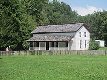
The park service maintains four historic districts and one archaeological district within park boundaries, as well as nine individual listings on the National Register of Historic Places. Notable structures not listed include the Mountain Farm Museum buildings at Oconaluftee and buildings in the Cataloochee area. The Mingus Mill (in Oconaluftee) and Smoky Mountain Hiking Club cabin in Greenbrier have been deemed eligible for listing.
Historic districts[]
- Cades Cove Historic District
- Elkmont Historic District
- Oconaluftee Archaeological District
- Noah Ogle Place
- Roaring Fork Historic District
Individual listings[]

- Alex Cole Cabin
- Clingmans Dome Observation Tower
- Hall Cabin (in Hazel Creek area)
- John Messer Barn
- John Ownby Cabin
- Oconaluftee Baptist Church (also called Smokemont Baptist Church)
- Tyson McCarter Place
- Mayna Treanor Avent Studio
- Little Greenbrier School
- Walker Sisters Place
See also[]
- Great Smoky Mountains Association
- Great Smoky Mountains Heritage Center
- Wildflowers of the Great Smoky Mountains
- List of birds of Great Smoky Mountains National Park
- List of national parks of the United States
Notes[]
- ^ Great Smoky Mountains in United States of America. protectedplanet.net. United Nations Environment World Conservation Monitoring Centre and the IUCN's World Commission on Protected Areas. Retrieved July 25, 2019.
- ^ "Great Smoky Mountains National Park". Geographic Names Information System. United States Geological Survey.
- ^ Jump up to: a b "Listing of acreage as of December 31, 2011" (PDF). Land Resource Division, National Park Service. Retrieved 7 March 2012.
- ^ "Annual Visitation Highlights". nps.gov. National Park Service. Retrieved 8 July 2020.
- ^ "Visitation Numbers". nps.gov. National Park Service. 2020. Retrieved 3 May 2020.
- ^ "Great Smoky Mountains National Park". nps.gov. National Park Service. Retrieved 3 May 2020.
- ^ Cuthbert, Lori; Yogerst, Joe (28 March 2019). "Everything to know about Great Smoky Mountains National Park". National Geographic. Retrieved 3 May 2020.
- ^ Jump up to: a b The National Parks: America's Best Idea. Ken Burns, broadcast on PBS.
- ^ "Global Context". nps.gov. National Park Service. Retrieved 3 May 2020.
- ^ "Sevier County's billion-dollar tourist industry grinds to a halt amid COVID-19 pandemic". WVLT-TV. Knoxville, Tennessee. 23 March 2020. Retrieved 3 May 2020.
- ^ Pierce, Daniel S. (2000). The Great Smokies: From Natural Habitat to National Park (1st ed.). Knoxville: University of Tennessee Press. pp. 2–5. ISBN 1-57233-076-7. OCLC 42619715.
- ^ "Images of the Great Smoky Mountains". dlc.lib.utk.edu. Retrieved 26 June 2018.
- ^ "Ben W. Hooper". tennesseeencyclopedia.net. Retrieved 13 August 2012.
- ^ MAB Biosphere Reserves Directory - UNESCO
- ^ "Wide-ranging celebration to honor 75th anniversary of the Great Smoky Mountains National Park". Retrieved 13 September 2016.
- ^ Rolando Zenteno; Jason Hanna; Madison Park. "Death toll in Sevier County still rising". CNN.
- ^ Laila Kearney and Dan Whitcomb. "Great Smoky Mountains fires leave three dead, 'scene of destruction' | Reuters". reuters.com. Retrieved 4 December 2016.
- ^ "Fires Near Smoky Mountains Prompt Mandatory Evacuations in Tennessee | NBC New York". nbcnewyork.com. Retrieved 4 December 2016.
- ^ Bracken, Matt (29 November 2016). "Gatlinburg evacuated after Great Smoky Mountains National Park fire". BaltimoreSun.com. Retrieved 5 December 2016.
- ^ "Slideshow: Great Smoky Mountain Wildfires | Fox News". foxnews.com. Retrieved 4 December 2016.
- ^ https://www.knoxmercury.com/2016/04/13/cassius-cash-smokies-first-african-american-superintendent-aims-help-park-evolve/
- ^ Moore 1988, p. 32.
- ^ Houk & Collier 1993, pp. 10-17.
- ^ "Natural Features & Ecosystems". US National Park Service. Retrieved 20 July 2007.
- ^ "USDA Interactive Plant Hardiness Map". United States Department of Agriculture. Retrieved 8 July 2019.
- ^ "PRISM Climate Group, Oregon State University". www.prism.oregonstate.edu. Retrieved 8 July 2019.
- ^ Jump up to: a b David M. Gaffin and David G. Hotz (2000). "A Precipitation and Flood Climatology with Synoptic Features of Heavy Rainfall across the Southern Appalachian Mountains" (PDF). 24 (3). National Weather Digest: 3–15. Cite journal requires
|journal=(help)CS1 maint: uses authors parameter (link) - ^ David M. Gaffin (2012). Southern Appalachian Weather. Vantage Press. ISBN 9780533165285. OCLC 811558967.
- ^ David M. Gaffin, David G. Hotz, and Terry I. Getz (2002). "An Evaluation of Temperature Variations around the Great Smoky Mountains National Park and their Associated Synoptic Weather Patterns" (NWS SR-221). NOAA Technical Memorandum: 8 pp. Cite journal requires
|journal=(help)CS1 maint: uses authors parameter (link) - ^ David M. Gaffin. "What are mountain waves?". National Weather Service - Morristown, TN.
- ^ David M. Gaffin (2009). "On High Winds and Foehn Warming Associated with Mountain-Wave Events in the Western Foothills of the Southern Appalachian Mountains". Weather and Forecasting. 24 (1): 53–75. Bibcode:2009WtFor..24...53G. doi:10.1175/2008WAF2007096.1.
- ^ Ryan Shadbolt, Joseph Charney, and Hannah Fromm (2019). "A mesoscale simulation of a mountain wave wind event associated with the Chimney Tops 2 fire (2016)" (Special Symposium on Mesoscale Meteorological Extremes: Understanding, Prediction, and Projection). American Meteorological Society: 5 pp. Cite journal requires
|journal=(help)CS1 maint: uses authors parameter (link) - ^ Feanny, Camille (24 June 2004). "Smokies top list of most polluted parks". CNN. Retrieved 28 December 2009.
- ^ "New Report Ranks Five Most-Polluted National Parks". National Parks Conservation Association. 24 June 2004. Archived from the original on 25 July 2011. Retrieved 14 June 2010.
- ^ Wenzler, Mark (12 March 2013). "New Report: Air Quality in the Smokies Is Headed in the Right Direction · National Parks Conservation Association". Retrieved 5 July 2016.
- ^ Dimas, Jennifer (7 March 2013). "Reducing Pollution at National Parks: Colorado State University Scientists Demonstrate Significant Improvements in Air Quality, Visibility - News & Information - Colorado State University". Archived from the original on 24 May 2013. Retrieved 5 July 2016.CS1 maint: unfit URL (link)
- ^ Mary Byrd Davis (23 January 2008). "Old Growth in the East: A Survey. North Carolina" (PDF). Archived from the original (PDF) on 17 February 2012.
- ^ "Black Bears - Great Smoky Mountains National Park". National Park Service.
- ^ "Elk - Great Smoky Mountains National Park". nps.gov. National Park Service. 21 July 2015. Retrieved 18 September 2020.
- ^ Simbeck, Damien (1990). Distribution of the Fishes of the Great Smoky Mountains National Park. p. 10 – via University of Tennessee.
- ^ "Visitation Numbers (U.S. National Park Service)". www.nps.gov. Retrieved 31 August 2020.
- ^ "Great Smoky Mountains: Recreational Opportunities". nps.gov. National Park Service. 2005. Archived from the original on 9 February 2006. Retrieved 20 May 2020.
- ^ "Firefly Event Lottery, Great Smoky Mountains National Park". Recreation.gov. Retrieved 20 October 2020.
- ^ "Synchronous Fireflies - Great Smoky Mountains National Park (U.S. National Park Service)". National Park Service.
References[]
- Campbell, Carlos Clinton (1960). Birth of a National Park in the Great Smoky Mountains. Knoxville, Tennessee: University of Tennessee Press. ISBN 9780870490293.
- Cotham, Steve (March 2009). Postcards of America: Great Smoky Mountains National Park. Mount Pleasant, South Carolina: Arcadia Publishing. ISBN 978-0738568546 – via Google Books.
- Houk, Rose; Collier, Michael (1993). Great Smoky Mountains National Park: A Natural History Guide. Boston: Houghton Mifflin. ISBN 0395599202 – via Google Books.
- Moore, Harry (1988). A Roadside Guide to the Geology of the Great Smoky Mountains National Park. Knoxville, Tennessee: University of Tennessee Press. ISBN 0870495585 – via Google Books.
- Pierce, Daniel S. (2000). The Great Smokies: From Natural Habitat to National Park. Knoxville, Tennessee: University of Tennessee Press. ISBN 1572330791 – via Google Books.
- Tilden, Freeman (1968). The National Parks. Ann Arbor, Michigan: University of Michigan Press – via Google Books.
External links[]
| Wikimedia Commons has media related to Great Smoky Mountains National Park. |
| Wikivoyage has a travel guide for Great Smoky Mountains National Park. |
- Official website
 of the National Park Service (NPS)
 - Atlas of the Smokies – NPS species location mapper
- Satellite image at NASA Earth Observatory
- General administrative files of Great Smoky Mountains National Park
- Great Smoky Mountains Association – nonprofit partner of the park
- Spring wildflower hikes at wildflowerpilgrimage.org
- The Influence of Terrain during the 27 April 2011 Super Tornado Outbreak and 5 July 2012 Derecho around the Great Smoky Mountains National Park
| show National parks of the United States |
|---|

| show World Heritage Sites in the United States |
|---|
| show Authority control |
|---|
- IUCN Category II
- Great Smoky Mountains National Park
- Great Smoky Mountains
- Biosphere reserves of the United States
- Blue Ridge National Heritage Area
- Civilian Conservation Corps in North Carolina
- Civilian Conservation Corps in Tennessee
- National parks in North Carolina
- National parks in Tennessee
- National parks of the Appalachians
- North Carolina outdoor recreation
- Old-growth forests
- Protected areas established in 1934
- Protected areas of Blount County, Tennessee
- Protected areas of Cocke County, Tennessee
- Protected areas of Haywood County, North Carolina
- Protected areas of Sevier County, Tennessee
- Protected areas of Swain County, North Carolina
- Southern Sixers
- Works Progress Administration in North Carolina
- Works Progress Administration in Tennessee
- World Heritage Sites in the United States
- Gatlinburg, Tennessee
- Geological type localities
- 1934 establishments in North Carolina
- 1934 establishments in Tennessee
- East Tennessee
- Western North Carolina
- Places with bioluminescence