Grenada North
Grenada North | |
|---|---|
Suburb of Wellington City | |
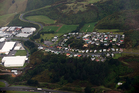
 Aerial view of residential area in Grenada North, Wellington, New Zealand. | |
 | |
| Country | New Zealand |
| City | Wellington City |
| Electoral ward | Takapū/Northern Ward[1] |
| Local board | Tawa Community Board[2] |
| Area | |
| • Land | 579 ha (1,431 acres) |
| Population (June 2021)[3] | |
| • Total | 2,420 |
| Postcode(s) | 5028[4] |
| Tawa | Takapu Valley | |
|
|
Horokiwi | |
| Glenside | Grenada |
Grenada North is a small suburb in northern Wellington, New Zealand. It is 5 km south of Porirua's city centre, and 13 km north of Wellington's city centre. Its western boundary is formed by State Highway 1 (SH 1N) and Takapu Road. The suburb itself was named after Grenada in the Caribbean, and most streets are named after Caribbean islands.
The Caribbean Avenue Reserve can be accessed from Caribbean Drive.
History[]
The suburb was developed by Glendene Developments Ltd in the 1970s so was originally called Glendene, and was expected to join up soon with the suburb of Grenada further south. To meet increased education demand in the Northern suburbs a new Glendene Secondary School was proposed, but by 1980 it was decided that a new co-ed secondary school was not needed and may never be needed. The 14.5 hectare site with sports fields in Jamaica Drive developed by the government was leased to the Wellington City Council for use as playing fields,[5] and was later (c1989) sold to the council. The residential area south towards Grenada is only now (c2015) being developed.
Demographics[]
Grenada North statistical area covers 5.79 km2 (2.24 sq mi).[6] It had an estimated population of 2,420 as of June 2021,[3] with a population density of 418 people per km2.
| Year | Pop. | ±% p.a. |
|---|---|---|
| 2006 | 2,007 | — |
| 2013 | 2,163 | +1.08% |
| 2018 | 2,286 | +1.11% |
| Source: [7] | ||
Grenada North had a population of 2,286 at the 2018 New Zealand census, an increase of 123 people (5.7%) since the 2013 census, and an increase of 279 people (13.9%) since the 2006 census. There were 726 households. There were 1,137 males and 1,146 females, giving a sex ratio of 0.99 males per female. The median age was 37.9 years (compared with 37.4 years nationally), with 468 people (20.5%) aged under 15 years, 444 (19.4%) aged 15 to 29, 1,122 (49.1%) aged 30 to 64, and 249 (10.9%) aged 65 or older.
Ethnicities were 74.5% European/Pākehā, 11.4% Māori, 7.9% Pacific peoples, 15.5% Asian, and 3.3% other ethnicities (totals add to more than 100% since people could identify with multiple ethnicities).
The proportion of people born overseas was 25.6%, compared with 27.1% nationally.
Although some people objected to giving their religion, 44.9% had no religion, 40.0% were Christian, 3.5% were Hindu, 1.3% were Muslim, 2.4% were Buddhist and 2.6% had other religions.
Of those at least 15 years old, 504 (27.7%) people had a bachelor or higher degree, and 204 (11.2%) people had no formal qualifications. The median income was $43,700, compared with $31,800 nationally. The employment status of those at least 15 was that 1,035 (56.9%) people were employed full-time, 264 (14.5%) were part-time, and 75 (4.1%) were unemployed.[7]
Aerial view[]

Commercial and industrial part of Grenada North, in northwest corner, facing southeast

Residential part of Grenada North, just south of commercial/industrial part, facing east
References[]
- ^ "Ward maps and boundaries". Wellington City Council. Retrieved 24 January 2022.
- ^ "Tawa Community Board". Wellington City Council. Retrieved 24 January 2022.
- ^ a b "Population estimate tables - NZ.Stat". Statistics New Zealand. Retrieved 22 October 2021.
- ^ "Wellington-Wairarapa Region" (PDF). Postcode Listings - Urban areas. New Zealand Post. 2011. Retrieved 14 September 2013.
- ^ Evening Post, 18 March 1980 p34
- ^ "ArcGIS Web Application". statsnz.maps.arcgis.com. Retrieved 19 June 2021.
- ^ a b "Statistical area 1 dataset for 2018 Census". Statistics New Zealand. March 2020. Grenada North (248000). 2018 Census place summary: Grenada North
Coordinates: 41°11′28″S 174°50′44″E / 41.191056°S 174.845438°E
- Suburbs of Wellington City


