Grizzly Peak (Oregon)
| Grizzly Peak | |
|---|---|
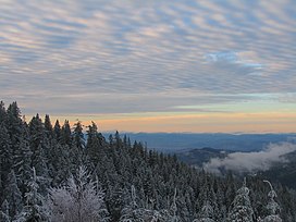 View from Grizzly Peak | |
| Highest point | |
| Elevation | 5,922 ft (1,805 m) NGVD 29[1] |
| Coordinates | 42°16′11″N 122°36′59″W / 42.2695838°N 122.6164359°WCoordinates: 42°16′11″N 122°36′59″W / 42.2695838°N 122.6164359°W[2] |
| Geography | |
 Grizzly Peak Location in Oregon | |
| Location | Jackson County, Oregon, U.S. |
| Topo map | USGS Grizzly Peak |
| Climbing | |
| Easiest route | Trail hike (class 1)[1] |

Grizzly Peak is a mountain in Jackson County, Oregon, overlooking the city of Ashland and the Bear Creek Valley. It has an elevation of 5,922 feet, and is located largely on Bureau of Land Management land. A trail exists to the summit.[1]
See also[]
References[]
- ^ Jump up to: a b c "Grizzly Peak Trail". Bureau of Land Management. Retrieved 2016-05-22.
- ^ "Grizzly Peak". Geographic Names Information System. United States Geological Survey. Retrieved 2016-05-22.
External links[]
- "Grizzly Peak". SummitPost.org.
| hide Authority control | |
|---|---|
| General |
|
| National libraries | |
This Oregon-related article is a stub. You can help Wikipedia by . |
Categories:
- Cascade Range
- Mountains of Jackson County, Oregon
- Mountains of Oregon
- Oregon stubs