Groom Lake (salt flat)
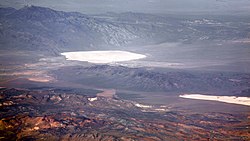
Groom Lake is a dry lake,[1] also described as a salt flat,[2] in Nevada. It is used for runways of the Nellis Bombing Range Test Site airport (KXTA).[3] Part of the Area 51 USAF installation, it lies at an elevation of 4,409 ft (1,344 m)[4] and is approximately 3.7 miles (6.0 km) from north to south and 3 miles (4.8 km) from east to west at its widest point, and is approximately 11.3 miles in circumference.[5] Located within the namesake Groom Lake Valley portion of the Tonopah Basin, the lake is 25 mi (40 km) south of Rachel, Nevada.[5]
The nearest publicly accessible vantage point is Tikaboo Peak, 26 miles to the east. There were two closer vantage points, dubbed "Freedom Ridge" and "White Sides", but they were closed to public access in 1995 to prevent people from taking pictures of the installation.[6]
History[]
Lead and silver were discovered in the southern part of the Groom Range in 1864,[7] and the English Groome Lead Mines Limited company financed the Conception Mines in the 1870s, giving the district its name (nearby mines included Maria, Willow and White Lake). The mining claims in Groom were acquired by J. B. Osborne and partners and patented in 1876, and Osborne's son acquired the interests in the 1890s.[8] The claims were proved in 1916 when two companies began working their mines; that work continued until 1918, and resuming after World War II until the early 1950s.[8]
In popular culture[]
Groom Lake is a location in the zombies maps "Moon" and "Classified" in the Call Of Duty: Black Ops franchise.
References[]
- ^ Annie Jacobsen (May 17, 2011). Area 51: An Uncensored History of America's Top Secret Military Base. Little, Brown. p. 7. ISBN 978-0-316-19385-6.
- ^ Leiby, Richard (August 16, 2013). "Government officially acknowledges existence of Area 51, but not the UFOs". Washington Post. Retrieved December 25, 2017.
- ^ Marsh, Alton K. (January 10, 2008). "Don't Ask, Don't Tell: Area 51 Gets Airport Identifier". AOPA. Maryland. Retrieved March 6, 2019.
Weinberger, Sharon (January 18, 2018). "Area 51's New Name: 'Homey Airport'". Wired. New York. Retrieved March 6, 2019. - ^ "Groom Lake (GNIS code 840824)". Geographic Names Information System. United States Geological Survey. Retrieved January 11, 2015.
- ^ a b DREAMLAND: Fifty Years of Secret Flight Testing in Nevada By Peter W. Merlin
- ^ "Freedom Ridge and Roadblock Canyon". Dreamland Resort.
- ^ Mineral resources of the Pahranagat Range 30' by 60' quadrangle Archived April 15, 2012, at the Wayback Machine, Joseph V. Tingley, Nevada Bureau of Mines and Geology, University of Nevada, Reno, 1989, retrieved June 11, 2010
- ^ a b "A Guide to the Records of The Groom Mining District Collection No. 99-19". University of Nevada, Reno. Retrieved September 21, 2016.
Coordinates: 37°16′N 115°48′W / 37.267°N 115.800°W

This Lincoln County, Nevada state location article is a stub. You can help Wikipedia by . |
- Lakes of Nevada
- Lakes of Lincoln County, Nevada
- Mining in Nevada
- Salt flats of the United States
- Lincoln County, Nevada geography stubs