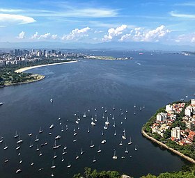
Guanabara Bay
| Guanabara Bay | |
|---|---|
 Guanabara Bay | |
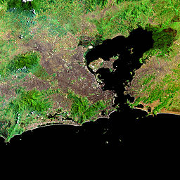 Satellite image of Guanabara Bay | |
| Location | Rio de Janeiro, Brazil |
| Coordinates | 22°47′25″S 43°9′20″W / 22.79028°S 43.15556°WCoordinates: 22°47′25″S 43°9′20″W / 22.79028°S 43.15556°W |
| Type | Bay |
| Native name | Baía de Guanabara (Portuguese) |
| River sources | |
| Ocean/sea sources | South Atlantic |
| Max. length | 31 km (19 mi) |
| Max. width | 28 km (17 mi) |
| Surface area | 412 km2 (159 sq mi) |
| Islands | Ilha do Governador, Ilha de Paquetá, Freguesia |
| Settlements | Rio de Janeiro, Niterói, Duque de Caxias, São Gonçalo |

Guanabara Bay (Portuguese: Baía de Guanabara, [ɡwɐ̃nɐˈbaɾɐ]) is an oceanic bay located in Southeast Brazil in the state of Rio de Janeiro. On its western shore lies the cities of Rio de Janeiro and Duque de Caxias, and on its eastern shore the cities of Niterói and São Gonçalo. Four other municipalities surround the bay's shores. Guanabara Bay is the second largest bay in area in Brazil (after the All Saints' Bay), at 412 square kilometres (159 sq mi), with a perimeter of 143 kilometres (89 mi).
Guanabara Bay is 31 kilometres (19 mi) long and 28 kilometres (17 mi) wide at its maximum. Its 1.5 kilometres (0.93 mi) wide mouth is flanked at the eastern tip by the Pico do Papagaio (Parrot's Peak) and the western tip by Pão de Açúcar (Sugar Loaf).
The name Guanabara comes from the Tupi language, goanã-pará, from gwa "bay", plus nã "similar to" and ba'ra "sea". Traditionally, it is also translated as "the bosom of sea".
History[]

Guanabara Bay was first encountered by Europeans on January 1, 1502, when one of the Portuguese explorers Gaspar de Lemos and Gonçalo Coelho[1] arrived on its shores. According to some historians,[2] the name given by the exploration team to the bay was originally Ria de Janeiro "January's Lagoon", then a confusion took place between the word ria "lagoon" and rio "river". As a result, the name of the bay was soon fixed as Rio de Janeiro. Later, the city was named after the bay. Natives of the Tamoio and Tupiniquim tribes inhabited the shores of the bay.
After the initial arrival of the Portuguese, no significant European settlements were established until French colonists and soldiers, under the Huguenot Admiral Nicolas Durand de Villegaignon invaded the region in 1555 to establish the France Antarctique. They stayed briefly on Lajes Island, then moved to Serigipe Island, near the shore, where they built Fort Coligny. After they were expelled by Portuguese military expeditions in 1563, the colonial government built fortifications in several points of Guanabara Bay, rendering it almost impregnable against a naval attack from the sea. They were the Santa Cruz, São João, Lajes and Villegaignon forts, forming a fearsome crossfire rectangle of big naval guns. Other islands were adapted by the Navy to host naval storehouses, hospitals, drydocks, oil reservoirs and the .
Underwater exploration in the bay was disallowed by the Brazilian government in 1985 amid a dispute with an American treasure hunter, who claimed to have found evidence of a Roman shipwreck.[3]
Description[]

There are more than 130 islands dotting the bay, including:
- Ilha do Governador – site of Rio de Janeiro's Galeão - Antônio Carlos Jobim International Airport
- Ilha de Paquetá
- Ilha das Cobras
- Ilha Fiscal
- Villegagnon
The bay is crossed by the Rio-Niterói Bridge (13.29 kilometres (8.26 mi) long and with a central span 72 metres (236 ft) high) and there is heavy boat and ship traffic, including regular ferryboat lines. The Port of Rio de Janeiro, as well as the city's two airports, Galeão - Antônio Carlos Jobim International Airport (on Governador Island) and Santos Dumont Airport (on reclaimed land next to downtown Rio), are located on its shores. The Federal University of Rio de Janeiro main campus is located on the artificial Fundão Island. A maze of smaller bridges interconnect the two largest islands, Fundão and Governador, to the mainland.
There is an Environmental Protection Area (APA), which is located mostly in the municipality of Guapimirim and given the name of Guapimirim APA.
Environment[]
Guanabara Bay's once rich and diversified ecosystem has suffered extensive damage in recent decades, particularly along its mangrove areas.[4] The bay has been heavily impacted by urbanization, deforestation, and pollution of its waters with sewage, garbage, and oil spills. As of 2014, more than 70% of the sewage from 12 million inhabitants of Rio de Janeiro now flows into the bay untreated.[5]
There have been three major oil spills in Guanabara Bay. The most recent was in 2000 when a leaking Petrobras underwater pipeline released 1,300,000 litres (340,000 US gal) of oil into the bay, destroying large swaths of the mangrove ecosystem. Recovery measures are currently being attempted, but more than a decade after the incident, the mangrove areas have not returned to life.
One of the world's largest landfills is located at Jardim Gramacho adjacent to Guanabara Bay. It was closed in 2012 after 34 years of operation. The landfill attracted attention from environmentalists and it supported 1700 people scavenging for recyclable materials.[6]

In June 2014 Dutch windsurfer and former Olympic and world champion Dorian van Rijsselberghe made an urgent appeal to government and industry in the Netherlands to collaborate in cleaning up the bay, together with the Plastic Soup Foundation.[7][8] The Dutch government picked up the message and formulated a Clean Urban Delta Initiative Rio de Janeiro together with a consortium of Dutch industry, knowledge institutes and NGOs which will be presented to the Brazilian authorities in the State of Rio de Janeiro.
As part of the preparations for the 2016 Summer Olympics in Rio, the government was supposed to improve the conditions, but progress has been slow. There have been concerns that the efforts may only be short-term and abandoned following the Games, as there would be little political incentive to continue with them.[9]
The marine ecosystem of Guanabara Bay was severely damaged;[10] the bay was once a whaling ground,[11][12][13] and today whales are no longer or rarely seen while Bryde's whales can be seen around the bay entrance.[14][15][16][17] The bay is also home to a population of botos[18][19] and this population faces severe risks of population decline.[20]
References[]
- ^ (in Portuguese) Jorge Couto, 1995, A Construção do Brasil, Lisbon: Cosmos.
- ^ (in Portuguese) Vasco Mariz, 2006, "Os Fundadores do Rio de Janeiro: Vespucci, Villegagnon ou Estácio de Sá?", in Brasil-França. Relações históricas no período colonial, Rio de Janeiro: Biblioteca do Exército, p. 80.
- ^ Simons, Marlise (June 25, 1985). "Underwater Exploring is Banned in Brazil". p. C3.
- ^ "Grassroot efforts lead the clean-up of Brazil's Guanabara Bay ahead of Rio 2016". The Guardian. 1 June 2015.
- ^ "'Super bacteria' found in Rio's Olympic waters". The Big Story.
- ^ Barchfield, Jenny (5 June 2012). "Rio closes massive Jardim Gramacho dump". TV3. Retrieved 7 June 2012.
- ^ "Een baai vol shit opruimen die hap - Life of Dorian". Dorian van Rijsselberghe.
- ^ "No Plastic in Our Water or Our Bodies".
- ^ Carneiro, Julia (10 January 2014). "Rio's Olympic waters blighted by heavy pollution". BBC News. Retrieved 12 January 2014.
- ^ Ruback C.. 2009. Saiba mais sobre a Baía de Guanabara. R7 (pt). Retrieved on Septem8er 18, 2017
- ^ HISTÓRICO - A PONTA DA ARMAÇÃO. Casa d’Armas da Ponta da Armação. Retrieved on Septem8er 18, 2017
- ^ Jorge S.. 2013. Baleias na Baía da Guanabara. Primeira Leitura. Retrieved on Septem8er 18, 2017
- ^ Barata C. . 2010. Rio Antigo - Pesca da Baleia 1790c LJ. YouTube. Retrieved on Septem8er 18, 2017
- ^ Rio, Mariucha MachadoDo G1 (13 March 2014). "Final de verão do Rio tem 'rolezinho' de baleias em busca de comida" [Late summer in Rio has whale watching in search of food]. Rio de Janeiro (in Portuguese).
- ^ Lodi L.. 2016. Baleia-de-bryde: Navegando com as gigantes. Blog ECONSERV – Ecologia, Conservação e Serviços. Retrieved on September 18, 2017
- ^ Lima D. L.. 2016. Frequentes na orla do Rio neste verão, baleias-de-bryde despertam curiosidade.Globo.com. Retrieved on Septem8er 18, 2017
- ^ Lodi, Liliane; Tardin, Rodrigo H.; Hetzel, Bia; Maciel, Israel S.; Figueiredo, Luciana D.; Simão, Sheila M. (April 2015). "Bryde's whale (Cetartiodactyla: Balaenopteridae) occurrence and movements in coastal areas of southeastern Brazil". Zoologia (Curitiba). 32 (2): 171–175. doi:10.1590/S1984-46702015000200009.
- ^ Ruback C.. 2009. Botos lutam para sobreviver na Baía de Guanabara. R7. Retrieved on Septem8er 18, 2017
- ^ ESPECIAL CETÁCEOS - BALEIAS: POR QUE PROTEGÊ-LAS?. Pick-upau. Retrieved on Septem8er 18, 2017
- ^ Dale J.. 2016. População de golfinhos da Baía de Guanabara sofre redução de 90% em três décadas. Globo.com. Retrieved on Septem8er 18, 2017
Further reading[]
![]() Media related to
Media related to
Guanabara Bay at Wikimedia Commons
- RGSSA catalogue. Bell, Alured Gray, 1870-1925 The Beautiful Rio de Janeiro. London : William Heinemann, 1914
- 'back to Rio'. RGSSA blog post, images of Guanabara Bay taken 1914
- Jablonski, Silvio; Azevedo, Alexandre de Freitas; Moreira, Luiz Henrique Arantes (January 2006). "Fisheries and conflicts in Guanabara Bay, Rio de Janeiro, Brazil". Brazilian Archives of Biology and Technology. 49 (1): 79–91. doi:10.1590/s1516-89132006000100010.
| Authority control |
|
|---|
- Guanabara Bay
- Bays of Brazil
- Bays of the Atlantic Ocean
- Landforms of Rio de Janeiro (state)
- Geography of Rio de Janeiro (city)
- Duque de Caxias, Rio de Janeiro
- Niterói
- Venues of the 2016 Summer Olympics
- Olympic sailing venues
- Cenozoic rifts and grabens
- Cenozoic South America