Guarenas-Guatire conurbation
Guarenas-Guatire conurbation
(Guarenas-Guatire Metropolitan Area) Conurbación Guarenas-Guatire Area Metropolitana de Guarenas-Guatire | |
|---|---|
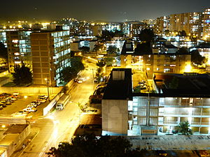 27 de Febrero neighborhood in Guarenas | |
| Country | |
| State | |
| Largest Cities | Guarenas Guatire |
| Area | |
| • Metro | 558 km2 (215 sq mi) |
| Population | |
| • Metro | 473,728 |
| • Metro density | 848.97/km2 (2,198.8/sq mi) |
| Time zone | UTC-4:30 (VST) |
Guarenas-Guatire conurbation [2][3][4] or Guarenas-Guatire metropolitan area (Spanish: Conurbación Guarenas-Guatire or Area Metropolitana de Guarenas-Guatire), also known as El Nuevo Este de Caracas (New East of Caracas), is a conurbation area in Miranda, Venezuela, that includes 2 municipalities, it is part of the Greater Caracas Area.[5] It has a population of 473,728 inhabitants.
Cities[]
The principal cities of the area are (2013):[1]
Municipalities[]
The 2 municipalities of the area are:
| Municipality | Area (km2)[6] | Population 2013 [1] | Population density 2013 (/km2) |
|---|---|---|---|
| Plaza | 180 | 264,290 | 1,468.27 |
| Zamora | 378 | 209,438 | 554.06 |
| Guarenas-Guatire conurbation | 558 | 473,728 | 848.97 |
Transportation[]
Metro and Light rail[]
The Guarenas / Guatire Metro is a dual subway / light rail system project to connect the twin cities and intermediate communities to Caracas. The 6.7 km (4.2 mi) urban line will start from the Caracas Metro station and end at the (Petare Norte) station, while the 31.4 km (19.5 mi) suburban line will start from the Guaraira Repano station and end at the Guatire II station with future extensions already in the planning stage.[7]
See also[]
- Greater Caracas
- List of metropolitan areas of Venezuela
External links[]
| Wikimedia Commons has media related to Guarenas. |
| Wikimedia Commons has media related to Guatire. |
- Estado Miranda
- guarenasonline.com
- plaza-miranda.gob.ve[permanent dead link] (in Spanish)
- zamora-miranda.gob.ve[permanent dead link] (in Spanish)
References[]
- ^ a b c "Archived copy" (PDF). Archived from the original (PDF) on 2015-09-23. Retrieved 2014-10-19.CS1 maint: archived copy as title (link)[full citation needed]
- ^ http://www.miranda.gov.ve/index.php?option=com_content&view=article&id=1100&Itemid=238 Archived 2016-03-04 at the Wayback Machine "Conurbación Guarenas-Guatire"
- ^ http://geodeg.com/search.php?q=miranda&language=&country=229&n=500 Conurbación Guatire-Guarenas
- ^ Oropeza, Mónica; Sáez Sáez, Vidal; Lemús, Jesús; Siso, Eunice; Barrios, Pedro (December 2009). "Riesgos por desbordamientos e inundaciones en la Cuenca del Río Guarenas, estado Miranda, Venezuela" [Overflow and floods risk for flooding in Guarenas River Basin, Miranda state, Venezuela]. Terra (in Spanish). 25 (38): 141–166. hdl:123456789/4989.
La conurbación Guarenas-Guatire-Araira forma parte del área metropolitana de la ciudad de Caracas; representa un conjunto de centros poblados de expansión para el crecimiento urbano e industrial (Díaz, 2005)
- ^ "Archived copy" (PDF). Archived from the original (PDF) on 2014-10-16. Retrieved 2014-10-09.CS1 maint: archived copy as title (link)[full citation needed] Conurbación Guarenas-Guatire: constituye una conurbación y como tal un centro regional de segundo orden, cuya forma y estructura están determinadas por la presencia de zonas naturales protegidas, las cuales la limitan y condicionan y constituye una zona de paso de los flujos provenientes de Caracas y que se dirigen a la zona de Barlovento y los estados orientales del país.
- ^ http://www.ine.gob.ve/documentos/see/sintesisestadistica2011/estados/miranda/index.htm Sintesis Estadistica de Miranda: POBLACIÓN[full citation needed]
- ^ "Estaciones del metro del tramo Guarenas-Guatire estarán listas para 2014". Economía. Agencia Venezolana de Noticias Torre Lincoln. 23 March 2012. Retrieved 25 November 2012.
This article related to a location in Miranda, Venezuela is a stub. You can help Wikipedia by . |
- Caracas
- Geography of Miranda (state)
- Metropolitan areas of Venezuela
- Guarenas
- Venezuela geography stubs