Guberlin Mountains
| Guberlin Mountains | |
|---|---|
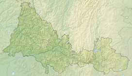 Guberlin Mountains Location | |
| Highest point | |
| Parent peak | Transverse (mountain) |
| Coordinates | 51°20′N 58°21′E / 51.333°N 58.350°ECoordinates: 51°20′N 58°21′E / 51.333°N 58.350°E |
| Geography | |
| Location | Orenburg Oblast |


Guberlinsky mountains — mountain range in the east Orenburg Oblast, in basin river (right tributary Ural). Southern part of Ural Mountains.
The Guberlin Mountains extend from north to south [1] for 70 km.[2] Their area is about 400 km2.[3] The mountains are heavily indented by the valley Guberli, as well as by the ravines, ravine s and ravines of its tributaries. The depth of some gorges reaches 80–100 m.[1] The prevailing heights are 300–350 m.[2] The highest peak is mountain .[3] In the southern part, the Guberlin Mountains turn into Mugodzhar Hills.
The mountains are mainly composed of tufa, siliceous and clayey slate.[2] steppe vegetation grows on the slopes, there are mosses and lichen and.[3] Within the mountains there are deposits of manganese, copper, iron and nickel ores (Akkerman nickel mine), chromium a, limestone and others minerals[2][4]
References[]
- ^ a b "Guberlinskie mountains" Our Ural website.
- ^ a b c d (in Russian) Губерлинские горы // Большая советская энциклопедия : [в 30 т.] / гл. ред. А. М. Прохоров. — 3-е изд. — М. : Советская энциклопедия, 1969—1978.
- ^ a b c "Archived copy". www.orenobl.ru. Archived from the original on 28 December 2011. Retrieved 17 January 2022.
{{cite web}}: CS1 maint: archived copy as title (link) - ^ Yanishevsky M. E. Report (preliminary) on a business trip to the Mugodzharsky and Guberlinsky mountains / M. E. Yanishevsky // Bulletin of the Tomsk Technological Institute [Izvestia TTI]. - 1905. - T. 3.
- Ural Mountains