Gugark
This article needs additional citations for verification. (March 2012) |
| Գուգարք | |
|---|---|
| Province of the ancient kingdom of Armenia | |
| 189 BC–13th century | |
 | |
| Capital | Ardahan |
| History | |
| History | |
• Artaxias I declaring himself independent | 189 BC |
• Disestablished | 13th century |
| Today part of | |
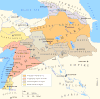
Gugark (Armenian: Գուգարք, Latin: Gogarene, Greek: Γογαρινή) was the 13th province of the ancient kingdom of Armenia. It now comprises parts of northern Armenia, northeast Turkey, and southwest Georgia.[1]
Etymology[]
Etymologically, Gugark in Armenian language denotes land of Gugars. word "Gugar" being a root and suffix -k meaning "land of".
History[]
At first, according to ancient Urartian inscriptions recorded in 785 BC, territory of Gugark was referred to as .[2] who, in all senses would be ancestors of the Georgian subgroup of Javakhians. In the beginning of IV century BC, (302BC) the territory was under Caucasian Iberia, but during Artaxias I's reign it was conquered.[3] During the reign of the Artaxiad and Arshakuni kings of Armenia, Gugark was ruled by one of the kingdom's four bdeshkhs. The bdeshkh of Gugark was responsible for protecting the state's northern border. During the 4th century, the region was ruled by members of a branch of the House of Mihran.[4] In 387, Armenia was partitioned between the Byzantine and Sassanid empires and Gugark, with the exception of the canton of Tashir, was annexed to Caucasian Iberia. most probably, because of the majority of the region being Gugars, who were an Iberian tribe. The ruler of the region around 425 was Archoucha (Arshusha of Gogarene). In 652, the Armenian prince Theodore Rshtuni was allowed by the Arabs to unite Gugark with his realms.

In the following centuries, Gugark and its cantons fell under the sway of several rulers. In the 8th century, it became a part of Emirate of Tbilisi. In the middle of the 9th century, it was taken by the Georgian Bagrationis, while the Armenian Bagratunis took over its eastern cantons.[1]
Inhabitants[]
Armenian catholicos Hovhannes Draskhanakerttsi says in his books that the majority of this region was Armenian people with minority of Iberian people. Also an Armenian historian Ghazar Parpetsi mentions Arshusha V pitiakhsh of Iberians.
Cantons[]
- Dzoropor
- Tsobopor
- Treghk
- Artahan
- Javakhk
- Upper Javakhk
- Tashir
- Kangark
- Kagharjk
- Nigal
- Mrugh
- Mrit
- Shavshet
- Koghbopor
- Kvishapor
- Boghnopor
- Tashran
- Manglyats
- Ashotsk
List of bdeshkhs[]
Based on available sources, Cyril Toumanoff deduced an incomplete list of the ruling Mihranid bdeshkhs of Gugark.[5]
| Name | Reign |
|---|---|
| Peroz | 330–361? |
| after 394–430 | |
| after 430–? | |
| mid 5th-century | |
| Arshusha II | ?–470 |
| Varsken | 470–482 |
| 482–after 540/1 | |
| ca. first decade of the 7th-century | |
| late 620s | |
| mid 8th-century |
See also[]
References[]
- ^ a b "Գուգարք". Armenian Soviet Encyclopedia. Vol. 3. Yerevan. 1975. p. 240-241.
- ^ Melkʻonyan, A. A. (2007). Javakhk in the 19th century and the 1st quarter of the 20th century : a historical research. Erevan: National Academy of Sciences of the Republic of Armenia, Institute of History. ISBN 978-99941-73-07-5. OCLC 607636080.
- ^ "Geography of Strabo, Book XI, Chapter 14, P325".
{{cite web}}: CS1 maint: url-status (link) - ^ Toumanoff, Cyril. Introduction to Christian Caucasian History, II: States and Dynasties of the Formative Period. Traditio 17 (1961), p. 38.
- ^ Rapp, Stephen H. (2014). The Sasanian World through Georgian Eyes: Caucasia and the Iranian Commonwealth in Late Antique Georgian Literature. Ashgate Publishing, Ltd. p. 389. ISBN 978-1472425522.
External links[]
Historical states and regions of Armenia | ||
|---|---|---|
| Independent Armenian states |
|  |
| Minor or dependent Armenian states |
| |
| Provinces or Ashkhars of Armenia Major | ||
| Other Armenian regions |
| |
| Other provinces under Tigranes the Great |
| |

- States and territories established in the 2nd century BC
- States and territories disestablished in the 13th century
- Provinces of the Kingdom of Armenia (antiquity)
- History of Ardahan Province