Gulf of Boni
| Gulf of Boni/Bone | |
|---|---|
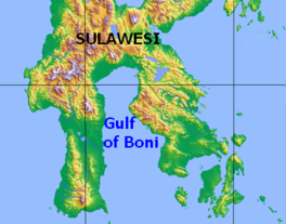 Map of the Gulf of Boni | |
 Gulf of Boni/Bone | |
| Location | Sulawesi |
| Coordinates | 4°0′S 120°45′E / 4.000°S 120.750°ECoordinates: 4°0′S 120°45′E / 4.000°S 120.750°E |
| Basin countries | Indonesia |

The Gulf of Boni[1] (Indonesian: Teluk Bone), also known as the Gulf of Bone, Bay of Boni, and Bone Bay, is the gulf which divides the South and Southeast Peninsulas of the island of Sulawesi (Celebes) in Indonesia. It opens on the south into the Banda Sea.[2]
Extent[]
The International Hydrographic Organization (IHO) defines the Gulf of Boni as being one of the divisions of the East Indian Archipelago.[3] It is defined as the waters north of the "line from Tg. Lassa, Celebes, to the North point of Kabaena (5°05′S 121°52′E / 5.083°S 121.867°E) and thence up this meridian to the coast of Celebes".[1]
See also[]
References[]
Citations[]
- ^ Jump up to: a b IHO (1953), §48 (k).
- ^ IHO (1953), §48 (g).
- ^ IHO (1953), §48.
Bibliography[]
- Limits of Oceans and Seas, 3rd ed. (PDF), International Hydrographic Organization, 1953, archived from the original (PDF) on 2018-10-05, retrieved 29 December 2020.
| hide Indonesian seas | |
|---|---|
| Ocean | |
| Sea | |
| Strait |
|
| Gulf | |
| Authority control |
|
|---|
This South Sulawesi location article is a stub. You can help Wikipedia by . |
This Southeast Sulawesi location article is a stub. You can help Wikipedia by . |
- Bays of Indonesia
- Landforms of Sulawesi
- Landforms of South Sulawesi
- Landforms of Southeast Sulawesi
- Banda Sea
- Sulawesi geography stubs