Gwadar Bay
This article does not cite any sources. (December 2009) |

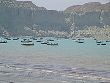
Gwadar Bay (Urdu: خلیج گوادر) is located in the Gulf of Oman on the maritime border of Pakistan and Iran. The name is from Persian, Khalij-e Gavader or "Gulf of Gwadar" on the Arabian Sea. It is an inlet of the Arabian Sea indenting the sandy Makran coast at the Iran–Pakistan border. It is about 30 kilometres (20 mi) long and 16 kilometres (10 mi) wide. The Dashtiari River flows into it from the northwest, and the Dasht River from the northeast. The town of Jiwani is located on the eastern end of the Gwadar Bay. The port city of Gwadar lies about 50 kilometres (30 mi) to the east, while the sister port city of Chabahar is located about 100 kilometres (62 mi) to the west of the Gwadar Bay.
Coordinates: 25°02′N 62°19′E / 25.033°N 62.317°E

This Pakistan location article is a stub. You can help Wikipedia by . |
- Bays of Pakistan
- Iran–Pakistan border
- Gulf of Oman
- Headlands of Pakistan
- Gwadar District
- Landforms of Balochistan (Pakistan)
- Gulfs of Iran
- Pakistan geography stubs