Håkøya
 View of Håkøya | |
 Håkøya Location of the island | |
| Geography | |
|---|---|
| Location | Troms og Finnmark, Norway |
| Coordinates | 69°39′16″N 18°47′35″E / 69.6544°N 18.7930°ECoordinates: 69°39′16″N 18°47′35″E / 69.6544°N 18.7930°E |
| Area | 3.69 km2 (1.42 sq mi) |
| Length | 3 km (1.9 mi) |
| Width | 2.3 km (1.43 mi) |
| Highest elevation | 105 m (344 ft) |
| Highest point | Skjellstonghaugen |
| Administration | |
Norway | |
| County | Troms og Finnmark |
| Municipality | Tromsø Municipality |


Håkøya is an island in Tromsø Municipality in Troms og Finnmark county, Norway.[1] The 3.69-square-kilometre (1.42 sq mi) island is located in the strait between the islands Kvaløya and Tromsøya. It is southeast of the village of on Kvaløya and west of the city of Tromsø on Tromsøya.
The higher elevations on the island are wooded, while residential houses, cabins, and farms are mostly located on the coastal areas. The island is connected to Kvaløya by the 330-metre (1,080 ft) long Håkøybrua. The original bridge was wooden, but the upper part was replaced with steel and concrete in 2004.
History[]
The German battleship Tirpitz was located at Håkøya starting on 15 October 1944 until 12 November 1944 when it was sunk by British bombers during Operation Catechism. A memorial to the roughly 1200 people who died on the Tirpitz now stands on Håkøya.
Media gallery[]

Håkøya, looking towards the city of Tromsø

Håkøy Bridge
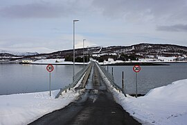
Håkøy Bridge

Tirpitz memorial


See also[]
References[]
| Wikimedia Commons has media related to Håkøya. |
- ^ "Håkøya, Tromsø (Troms)" (in Norwegian). yr.no. Retrieved 2018-08-12.
This article about an island in Troms og Finnmark is a stub. You can help Wikipedia by . |
- Tromsø
- Islands of Troms og Finnmark
- Troms og Finnmark geography stubs
- Troms og Finnmark island stubs