Høgeloft
| Høgeloft | |
|---|---|
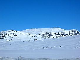 The massif of Jukleeggi, Høgeloft is right behind. | |
| Highest point | |
| Elevation | 1,920 m (6,300 ft) |
| Prominence | 790 m (2,590 ft)[1] |
| Isolation | 37.2 to 37.4 m (122 to 123 ft) |
| Coordinates | 61°03′14″N 8°12′49″E / 61.0539°N 8.2137°ECoordinates: 61°03′14″N 8°12′49″E / 61.0539°N 8.2137°E[2] |
| Geography | |
 Høgeloft Location of the mountain | |
| Location | Vestland and Viken, Norway |
| Parent range | Filefjell |
| Topo map | 1517 II Øye |


Høgeloft is a mountain on the border between the municipalities of Lærdal (in Vestland county) and Hemsedal (in Viken county), Norway. At 1,920 metres (6,300 ft) above sea level, it is the highest mountain in the Filefjell mountain range. Høgeloft one of the mountains in the Hemsedal Top 20 group.[1]
Høgeloft is located about 22 kilometres (14 mi) east of the village of Borgund in Lærdal, not far from the European route E16 highway and the old Filefjell Kongevegen road. The lake Juklevatnet lies at the southern base of the mountain and the lake Eldrevatnet lies 5 kilometres (3.1 mi) to the southwest of the mountain.
References[]
- ^ a b "Høgeloft". Retrieved 2010-09-06.
- ^ "Høgeloft, Lærdal (Vestland)" (in Norwegian). yr.no. Retrieved 2020-01-19.
This article about a mountain, mountain range, or peak in Viken is a stub. You can help Wikipedia by . |
This article about a mountain, mountain range, or peak in Vestland is a stub. You can help Wikipedia by . |
- Mountains of Viken
- Mountains of Vestland
- Lærdal
- Hemsedal
- Viken (county) mountain stubs
- Vestland mountain stubs