Hallett Peninsula
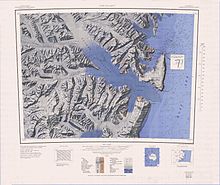
Hallett Peninsula (72°30′S 170°10′E / 72.500°S 170.167°ECoordinates: 72°30′S 170°10′E / 72.500°S 170.167°E) is a triangular, dome-shaped peninsula, 20 nautical miles (37 km) long, with 1,500-metre (4,900 ft) cliffs on its eastern seaboard side and 300-metre (1,000 ft) on its west side. The peninsula extends from Cape Hallett to Cape Wheatstone and is joined to the mainland by a narrow ridge between Tucker Glacier and Edisto Inlet. It was so named by the New Zealand Geological Survey Antarctic Expedition, 1957–58, because Hallett Station on Seabee Hook was established at the north end of the peninsula.[1]
 WikiMiniAtlas
The peninsula is an elongated shield volcano complex similar to the Adare and Daniell peninsulas. It forms part of the Hallett Volcanic Province of the McMurdo Volcanic Group.[2] Basaltic lava of the Hallett Peninsula has been dated to 6.4 ± 0.4 million years old.[3]
See also[]
References[]
- ^ "Hallet Peninsula". Geographic Names Information System. United States Geological Survey. Retrieved 2012-05-17.
- ^ Riffenburgh, Beau (2007). Encyclopedia of the Antarctic. Vol. 1. Taylor & Francis. p. 639. ISBN 0-415-97024-5.
- ^ "K/Ar and Rb/Sr dating of McMurdo Volcanic Group (north of Campbell Glacier)" (PDF). Geological Society of America. p. 1.
![]() This article incorporates public domain material from the United States Geological Survey document: "Hallett Peninsula". (content from the Geographic Names Information System)
This article incorporates public domain material from the United States Geological Survey document: "Hallett Peninsula". (content from the Geographic Names Information System)
This Borchgrevink Coast location article is a stub. You can help Wikipedia by . |
- Peninsulas of Antarctica
- Landforms of Victoria Land
- Borchgrevink Coast
- Volcanoes of Victoria Land
- Shield volcanoes
- Miocene volcanoes
- Borchgrevink Coast geography stubs