Hamningberg
Hamningberg
Havningberg | |
|---|---|
Abandoned Village | |
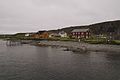
 View of the village | |
 Hamningberg Location in Finnmark | |
| Coordinates: 70°32′26″N 30°36′52″E / 70.54056°N 30.61444°ECoordinates: 70°32′26″N 30°36′52″E / 70.54056°N 30.61444°E | |
| Country | Norway |
| Region | Northern Norway |
| County | Finnmark |
| District | Øst-Finnmark |
| Municipality | Båtsfjord |
| Elevation | 7 m (23 ft) |
| Time zone | UTC+01:00 (CET) |
| • Summer (DST) | UTC+02:00 (CEST) |

Hamningberg is an abandoned fishing village in Båtsfjord Municipality in Finnmark county, Norway. The village lies along the northern coast of the large Varanger Peninsula on the shores of the Barents Sea. Its only road connection is through Vardø Municipality which is a rather long drive from the rest of Båtsfjord Municipality. Hamningberg Chapel is located in the village, although now it is only rarely used.[2]
Traditionally a fishing village, it is one of very few places in all of Finnmark county that was not burned down by the retreating Germans in the latter part of the Second World War. It was depopulated and abandoned in 1964, although some of the houses are still in use as summer cottages.[3]
Media gallery[]

Houses in Hamningberg

View of the shoreline
Another view of the shoreline

The churchyard in Hamningberg


References[]
- ^ "Hamningberg" (in Norwegian). yr.no. Retrieved 2013-02-27.
- ^ Store norske leksikon. "Hamningberg" (in Norwegian). Retrieved 2013-02-27.
- ^ Tonstad, Per Lars (22 June 1998). "Edvald - ildsjel ytterst i Europa". Dagbladet (in Norwegian). Archived from the original on 6 October 2011. Retrieved 6 October 2011.
External links[]
 Media related to Hamningberg at Wikimedia Commons
This article about a location in Troms og Finnmark is a stub. You can help Wikipedia by . |
- Båtsfjord
- Former populated places in Finnmark
- Villages in Norway (depopulated)
- Troms og Finnmark geography stubs