Hardbrücke
Hardbrücke | |
|---|---|
 Hardbrücke bridge and railway station | |
| Coordinates | 47°23′07″N 8°31′02″E / 47.38514°N 8.51717°ECoordinates: 47°23′07″N 8°31′02″E / 47.38514°N 8.51717°E |
| Crosses | River Limmat Zürich–Baden railway Various streets |
| Locale | City of Zürich, Canton of Zürich, Switzerland |
| Characteristics | |
| Design | Girder bridge |
| Total length | 1,350 m (4,430 ft) |
| Width | 17.5 m (57 ft) to 28.4 m (93 ft) |
| History | |
| Construction start | 1969 |
| Opened | 1972 |
| Location | |
 | |

The Hardbrücke is a road bridge and important north-south connection in the Swiss city of Zürich. The bridge is 1,350 metres (4,430 ft) long, and crosses the river Limmat, the Zürich–Baden railway, and several streets. In crossing the river, the Hardbrücke forms an upper level to the lower level Wipkingerbrücke road bridge. Between the river and rail crossings, several exit and entrance ramps link the bridge to the streets below.
Construction of the bridge commenced in 1969 and it was opened in 1972. The bridge underwent a major refurbishment between 2009 and 2011.
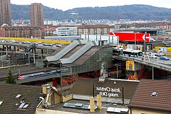
At the point at which the bridge crosses the railway tracks, it provides access to Zürich Hardbrücke railway station below on the Zürich S-Bahn. Zürich trolleybus routes 33, 72 and , and tram route 8 serve the adjacent stop on the bridge.[1] [2]
Gallery[]
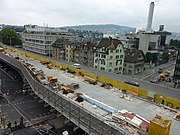
The Hardbrücke during its 2010 refurbishment

The Hardbrücke by night

Aerial view

View from Hardbrücke


References[]
- ^ "City of Zurich Plan" (PDF). Zurich, Switzerland: ZVV. Retrieved 2019-11-06.
- ^ Eisenbahnatlas Schweiz. Verlag Schweers + Wall GmbH. 2012. pp. 64–65. ISBN 978-3-89494-130-7.
External links[]
 Media related to Hardbrücke at Wikimedia Commons
This article about a bridge in Switzerland is a stub. You can help Wikipedia by . |
- Bridges in Zürich
- Road bridges in Switzerland
- European bridge (structure) stubs
- Swiss building and structure stubs
- Switzerland transport stubs