Hassanabad, Chorbat
This article includes a list of references, related reading or external links, but its sources remain unclear because it lacks inline citations. (December 2011) |
Hassanabad
حسن آباد | |
|---|---|
      Hassanabad,Chorbat,Gilgit Baltistan, Pakistan | |
 Hassanabad Hassanabad on Gilgit-Baltistan Map | |
| Coordinates: 34°58′24″N 76°32′25″E / 34.97333°N 76.54028°ECoordinates: 34°58′24″N 76°32′25″E / 34.97333°N 76.54028°E | |
| Country | Pakistan |
| Administrative Territory | Gilgit Baltistan |
| Time zone | UTC+5 (PST) |
| • Summer (DST) | UTC+6 (GMT+5) |

Hassanabad (Urdu: حسن آباد) is a village in Sub-Division Chorbat, Ghangche District of Gilgit-Baltistan, Pakistan, lying 141 kilometres (88 mi) east of Skardu, near the border of India.
Etymology[]
The ancient name of Hassanabad was Kusting, which means a large storage of water. It is said that in ancient times the lama (Bhudhist spiritual leader), who ruled the area name was Lama Kastiyang. and the name Kusting was derived from the lama's name. The language spoken is Balti. The entire population is Muslim of the Sofia Noorbakhshia In the past it was the trade route to Ladakh and Kargil.
Geography[]
Hassanabad has an average elevation of about 2,670 metres (8,760 ft), and is situated along the banks of the Shyok River, a tributary of the Indus. Villages near Hassanabad includes Marcha, Dawoo, Piun, Partuk, Siksa and Franu.
The mountains and surrounding have generally no forests however there are some shrubs and herbs available which are generally used by the local communities as medicinal herbs and for their cattle, The Shyok River passing nearby the village is one of the important resources for irrigating the whole lands. However the same river sometime creates havoc during summer through its unpredictable floods.
Administrartion[]
Hassanabad consists of 7 block. Painkhor, Gabkhor, Thangkhor, Hajipakhor, Goostrang, Komick and Oraitan
Climate[]
The climate of Hassanabad during the summer is moderated by its mountain setting and the intense heat of lowland Pakistan does not reach here. The mountains also block out the summer monsoon and summer rainfall is thus quite low. However, these mountains result in very severe winter weather. During the April to October temperatures vary between a maximum of 27 °C and a minimum (in October) 8 °C. However, temperatures can drop to below -26 °C in the December-to-February midwinter period.
Resources[]
The natural resources of the village include agriculture, horticultural resources, the Shyok River, mountains and peaks. The agriculture in the village is only summer based due to extreme cold in the winter where temperature goes to -26 C. The crops include some beans, maize, potatoes, and other food crops however communities have experimented less with the agriculture due to the natural limiting factors i.e. extreme cold.
Transport[]
Hassanabad is accessible only by the road, The normal route to Hassanabad is via Shyok Valley Road, that connect it to the District Headquarters Khaplu and to Skardu. The climate can have adverse effects on transport in and out of the Hassanabad, as the roads in and out of can be blocked for weeks.


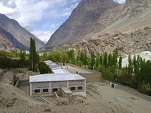
Veterinary Hospital Hassanabad Chorbat
Govt High School Hassanabad

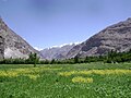
Beautiful view Mountain, apricot tree and green fields Hassanabad Chorbat


References[]
| Wikimedia Commons has media related to Hassanabad, Chorbat. |
- Shridhar Kaul (1992). Ladakh through the Ages, towards a New Identity. Indus Publishing. ISBN 81-85182-75-2.
- Sarina Singh; Lindsay Brown; Paul Clammer; Rodney Cocks; John Mock; Kimberley O'Neil (2008). Pakistan & the Karakoram Highway. Lonely Planet. pp. 292–293. ISBN 1-74104-542-8.
- Raja Iftikhar. The History of Baltistan.
- Iftikhar Ali Raja Zahid. Waadi-E-Chorbat.
- Populated places in Ghanche District
- Baltistan