Hatteras, North Carolina
Hatteras, North Carolina | |
|---|---|
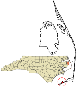 Location in Dare County and the state of North Carolina | |
| Coordinates: 35°13′10″N 75°41′25″W / 35.21944°N 75.69028°WCoordinates: 35°13′10″N 75°41′25″W / 35.21944°N 75.69028°W | |
| Country | United States of America |
| State | North Carolina |
| County | Dare |
| Named for | Hatteras Indians |
| Area | |
| • Total | 1.68 sq mi (4.36 km2) |
| • Land | 1.58 sq mi (4.08 km2) |
| • Water | 0.11 sq mi (0.29 km2) |
| Elevation | 3 ft (0.9 m) |
| Population (2010) | |
| • Total | 504 |
| • Density | 320/sq mi (123.6/km2) |
| ZIP code | 27943 |

Hatteras is an unincorporated village and census-designated place (CDP) in Dare County, North Carolina, United States, on the Outer Banks island of Hatteras, at its extreme southwestern tip. As of the 2010 census it had a population of 504.[1] Immediately to the west of the village of Hatteras is Hatteras Inlet which separates Hatteras Island from the neighboring Ocracoke Island. North Carolina Highway 12 passes through the community linking it to Frisco to the east and Ocracoke to the west (via a ferry across Hatteras Inlet).
The residents of Hatteras are governed by the Dare County Board of Commissioners. Hatteras is part of District 4, along with Avon, Buxton, Frisco, Rodanthe, Waves and Salvo.
Attractions and recreation[]
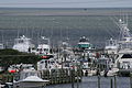
Hatteras is best known as a fishing and vacation destination.
Watersports are plentiful on both the ocean-side and the sound-side of the village. Proximity to the convergence of the Labrador Current and the Gulf Stream result in the largest surf available on the East Coast. On the protected Pamlico Sound side of the island watersports such as windsurfing, kayaking, kiteboarding, and swimming are all readily available and accessible.
Fishing is a major source of recreation as well as revenue in Hatteras.
Pamlico Sound, which separates Hatteras and Ocracoke Islands, is one of the largest estuarine systems in the world and offers a variety of fishing opportunities.[2]
Climate[]
Hatteras has a humid subtropical climate (Cfa). Hatteras experiences hot summers, somewhat moderated by the Atlantic Ocean, and some of the mildest winters in the entire state, with no month having an average low temperature below 40 °F (4.4 °C). Because of its location many miles off the coast of Mainland USA right in the direct path of the gulf stream, Hatteras experiences year round low temperatures similar to the northern gulf of Florida or Southern coastal Georgia despite being much farther North.[3]
History[]
Hatteras was named after the Hatteras Indians.[5]
Hatteras Village was cut off from the rest of the island on September 18, 2003,[6] when Hurricane Isabel washed a 3,000-foot-wide (910 m) and 30-foot-deep (9.1 m) channel called Isabel Inlet at the north end of Hatteras village. The tear was subsequently repaired and restored by sand dredged by the Army Corps of Engineers.[7]
The Ellsworth and Lovie Ballance House and Hatteras Weather Bureau Station are listed on the National Register of Historic Places.[8]
Transportation[]
Hatteras is served by Billy Mitchell Airport.
Education[]
Residents are zoned to Dare County Schools. Zoned schools are Cape Hatteras Elementary School and Cape Hatteras Secondary School.[9] The schools are located on NC 12 in Buxton.[10]
Dare County Library has a branch in Hatteras.[11]
Gallery[]
View of Pamlico Sound, near Hatteras Inlet from a home in Hatteras on a windy day in June 2007

View of homes along oceanfront in Hatteras in June 2007

Busy Hatteras Ferry Lines on a Wednesday in June 2007

Ferries making trip from Ocracoke to Hatteras, June 2007

Water tower
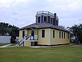
Historical US Weather Bureau office


Notes[]
- ^ Mean monthly maxima and minima (i.e. the expected highest and lowest temperature readings at any point during the year or given month) calculated based on data at said location from 1981 to 2010.
References[]
- ^ "Geographic Identifiers: 2010 Demographic Profile Data (G001): Hatteras CDP, North Carolina". U.S. Census Bureau, American Factfinder. Archived from the original on February 13, 2020. Retrieved November 24, 2015.
- ^ Bill Blue, ed. (Summer 2007). "Fishing: Hatteras and Ocracoke Style, Sunny Day Guide". Surfside East. pp. 34, 63–65.
- ^ Team, National Weather Service Corporate Image Web. "National Weather Service Climate". w2.weather.gov. Retrieved 2020-07-02.
- ^ "NOAA 1981-2010 Climate Normals". University of Washington. Retrieved 2016-12-21.
- ^ Gannett, Henry (1905). The Origin of Certain Place Names in the United States. Govt. Print. Off. p. 152.
- ^ "AFTER THE STORM: THE SCENE; Fickle Isabel Devastates Parts of Hatteras", in The New York Times, September 20, 2003. Retrieved May 8, 2008.
- ^ Hatteras Village, "N.C., Breach Cut by Hurricane Isabel Is Filled with Sand," in The News & Observer, November 4, 2003. Retrieved May 8, 2008. Archived June 28, 2014, at the Wayback Machine
- ^ "National Register Information System". National Register of Historic Places. National Park Service. July 9, 2010.
- ^ "Attendance Zone Information". Dare County Schools. Retrieved 2021-04-12.
Cape Hatteras Elementary School -- All areas South of the Oregon Inlet Bridge[...]Cape Hatteras Secondary School -- All areas South of the Oregon Inlet Bridge
- ^ Dare County Schools Website Archived 2007-06-30 at the Wayback Machine
- ^ "Home". Dare County Library. Retrieved 2021-04-13.
External links[]
| show Municipalities and communities of Dare County, North Carolina, United States |
|---|

- Census-designated places in Dare County, North Carolina
- Beaches of North Carolina
- Hatteras Island
- Beaches of Dare County, North Carolina
- Populated coastal places in North Carolina