Hatton, Warrington
| Hatton | |
|---|---|
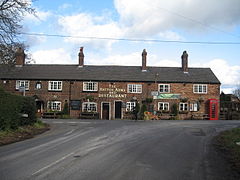 The Hatton Arms public house, Hatton | |
 Hatton Location within Cheshire | |
| OS grid reference | SJ597825 |
| Civil parish |
|
| Unitary authority | |
| Ceremonial county | |
| Region | |
| Country | England |
| Sovereign state | United Kingdom |
| Post town | WARRINGTON |
| Postcode district | WA4 |
| Dialling code | 01925 |
| Police | Cheshire |
| Fire | Cheshire |
| Ambulance | North West |
| UK Parliament | |

Hatton is a civil parish and hamlet in Warrington, Cheshire, England, located to the south of Warrington town centre.
It lies on the B5356 road between the villages of Daresbury and Stretton.[1] It has one public house, The Hatton Arms. This is a Grade II listed building which formerly incorporated a post office and a village store.[2] Two other listed buildings are Hatton Hall and a K6 telephone kiosk designed by Giles Gilbert Scott.[3]
See also[]
References[]
- ^ Bolton, Wigan & Warrington: Explorer 276 map, Ordnance Survey.
- ^ Historic England, "The Hatton Arms, Hatton (1329768)", National Heritage List for England, retrieved 7 February 2013
- ^ "Hatton Village, Cheshire - Hatton Life". Hatton Life. Retrieved 2 July 2017.
External links[]
![]() Media related to Hatton, Warrington at Wikimedia Commons
Media related to Hatton, Warrington at Wikimedia Commons
This Cheshire location article is a stub. You can help Wikipedia by . |
Categories:
- Civil parishes in Warrington
- Villages in Cheshire
- Cheshire geography stubs