Haukadalur
This article includes a list of references, related reading or external links, but its sources remain unclear because it lacks inline citations. (August 2016) |
| Haukadalur | |
|---|---|
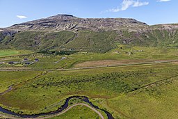 View of the Haukadalur valley from Laugarfjall | |
 Location in Iceland | |
| Location | Southwestern Iceland |
| Coordinates | 64°18′40″N 20°17′2″W / 64.31111°N 20.28389°WCoordinates: 64°18′40″N 20°17′2″W / 64.31111°N 20.28389°W |

Haukadalur (Icelandic: [ˈhœiːkaˌtaːlʏr̥], from Old Norse: Haukadalr [ˈhɔukɑˌdɑlz̠], "hawk dale" or "valley of hawks") is a valley in Iceland. It lies to the north of Laugarvatn lake in the south of Iceland.
Geysers[]
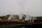
Haukadalur is home to some of the best known sights in Iceland: the geysers and other geothermal features which have developed on the Laugarfjall [ˈlœiːɣarˌfjatl̥] rhyolitic dome. The biggest geysers of Haukadalur are Strokkur and Geysir itself, which gave us the word 'geyser'. Strokkur is very dependable and erupts every 5 to 10 minutes, whereas the bigger Geysir nowadays erupts very rarely. There are also more than 40 other smaller hot springs, mud pots and fumaroles nearby.
Haukadalur geothermal area was first mentioned in written sources around 1294, when the local hot springs were activated by an earthquake. Earthquakes are also known to have activated local geysers in the recent past, including the earthquakes that occurred on 17 and 21 July 2000. Due to the geysers the valley has been a popular tourist attraction since the 18th century.
Nearby attractions[]
The Gullfoss waterfall is about 10 km to the north in the direction of the Highlands of Iceland, via the beginning of the Kjölur highland road. Along with Gullfoss and Þingvellir, Haukadalur is part of the Golden Circle.
Gallery[]

Haukadalur in September 2017, Iceland

Haukadalur in May 2016, Iceland
Haukadalur, Iceland

Geothermal area of Geysir

Litli Geysir, Haukadalur, Iceland


See also[]
- List of cities and towns in Iceland
- List of earthquakes in Iceland
- List of waterfalls of Iceland
- Volcanology of Iceland
References[]
| Authority control |
|
|---|
- Forests of Iceland
- Valleys of Iceland
- Southern Region (Iceland)