Haveri
Haveri | |
|---|---|
CMC | |
 Yalakki | |
| Nickname(s): Yalakki Kampina Nadu
(The land of Cardamom smell) | |
 Haveri Location in Karnataka, India | |
| Coordinates: 14°47′38″N 75°24′14″E / 14.79389°N 75.40389°ECoordinates: 14°47′38″N 75°24′14″E / 14.79389°N 75.40389°E | |
| Country | |
| State | |
| Region | Bayaluseeme |
| District | Haveri district |
| Area | |
| • Total | 26.19 km2 (10.11 sq mi) |
| Elevation | 571 m (1,873 ft) |
| Population | |
| • Total | 67,102 |
| • Density | 2,134.89/km2 (5,529.3/sq mi) |
| Languages | |
| • Official | Kannada ಕನ್ನಡ |
| Time zone | UTC+5:30 (IST) |
| PIN | 581 110 |
| Telephone code | 08375 |
| Vehicle registration | KA-27 |

Haveri is a town in Karnataka, India. It is the administrative headquarters of Haveri district.[1] Haveri is famous for its cardamom garlands and Byadagi red chillies. Around 25 km away, there is a place called Bada, which is the birthplace of the poet Kanakadasa.
The name Haveri is derived from the Kannada words haavu and keri, which means place of snakes.[citation needed] It is said[where?] that Haveri had around 1000 mathas (sacred religious places; Kannada - ಮಠ) in ancient days. One of the famous mathas is Hukkeri Math.[citation needed]
Haveri is 7 hours away from Bengaluru by train. By road, it is about 340 km from Bengaluru on NH-48 towards Mumbai. It is located 307 km north of the port city Mangalore.
Tourist attractions of Haveri[]

- Siddheshvara Temple[2]

The centre of Western Chalukya architectural developments was the region including present-day Bagalkot, Gadag, Koppal, Haveri and Dharwad districts;
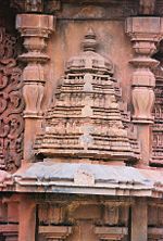
Siddheshwara temple at Haveri a staggered square plan with dravida articulation and superstructure, 11th century CE. Miniature decorative dravida and nagara style towers at Siddheshvara Temple in Haveri
- Basavanna Temple
- Utsav Rock Garden is situated at Gotagodi on NH-4 Shiggaon Taluk. It is blended with both modern and art where more than 1000 real life size sculptures are present. It has got 8 world records. It is a unique garden in the whole world.

Geography[]
Haveri is located at 14°48′N 75°24′E / 14.8°N 75.4°E.[3] It has an average elevation of 572 metres (1876 feet).
Education[]
There are a number of private, aided and government schools and colleges that offer courses in PU, degree and master's degrees.

There is also a new govt medical college started in haveri in 2020.
Demographics[]
As of 2011 India census,[4] Haveri had a population of 67102. Males constitute 51% of the population and females 49%. Haveri has an average literacy rate of 70%, higher than the national average of 59.5%: male literacy is 76%, and female literacy is 64%. In Haveri, 13% of the population is under 6 years of age.
See also[]
|
|
References[]
- ^ "Karnataka, The Tourist Paradise". Archived from the original on 4 March 2009. Retrieved 17 October 2008.
- ^ "JSTOR: Sculptures from the Later Calukyan Temple at Haveri". 31: 167–178. JSTOR 3249429. Cite journal requires
|journal=(help) - ^ Falling Rain Genomics, Inc - Haveri
- ^ "Census of India 2011: Data from the 2011 Census, including cities, villages and towns (Provisional)". Census Commission of India. Archived from the original on 16 June 2004. Retrieved 1 November 2008.
- Chalukya dynasty
- Western Chalukya Empire
- Cities and towns in Haveri district