Hawaii Route 56
 | ||||
|---|---|---|---|---|
| Kuhio Highway | ||||
 Route 56 highlighted in red | ||||
| Route information | ||||
| Maintained by HDOT | ||||
| Length | 28.2 mi[1] (45.4 km) | |||
| Existed | 1955–present | |||
| Major junctions | ||||
| South end | ||||
| North end | ||||
| Location | ||||
| Counties | Kauai | |||
| Highway system | ||||
| ||||
| ||||
Route 56, also known as Kuhio Highway, is the main highway on the north and east shore of Kauaiʻi island in Kauai County, Hawaii, United States.
Route description[]

Route 56 runs 28 miles (45 km), stretching from Hawaii Route 50 at the junction of Rice Street in Lihue to the junction of Hawaii Route 560 in Princeville on the island of Kauaiʻi. The road is named for Prince Jonah Kūhiō Kalaniana'ole, a territorial delegate to Congress after Hawaii's annexation by the United States.

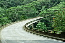
The road is a major thoroughfare for the eastern and northern parts of Kauaiʻi. Leaving Lihue, the road passes through the only Wal-Mart and the major hospital on the island. The road connects with Hawaii Route 51 to Lihue Airport. Following the intersection the road briefly passes through some rural patches with the occasional resort before crossing the Wailua River. At the Wailua River, there is a two lane southbound bridge and also a two lane northbound bridge. A bridge expansion was completed in 2011. Going through Wailua and Kapaa, Hawaii 56 is jammed in the morning and the afternoon. Contra flow alleviates rush hour traffic in the morning between Kapaa and Lihue Airport. The southbound lane gets two lanes in the morning to alleviate traffic pressures. Contra flow traffic starts at 6:00 AM on weekdays and 8:00 AM Saturday. Traffic is switched back to normal starting from the north at 11:00 am weekdays and 1:30 pm on Saturday. The traffic pressure dissipates going through some of the most gorgeous scenic countryside with few services and buildings from Kapaa heading towards Princeville. The bridge over the Kalihiwai river west of Kilauea is particularly scenic.
Major intersections[]
The entire route is in Kauai County.
| Location | mi | km | Destinations | Notes | |
|---|---|---|---|---|---|
| Lihue | 0.0 | 0.0 | Southern terminus of Route 56; eastern terminus of Route 50 | ||
| Northern terminus of Route 51 | |||||
| Wailua | Eastern terminus of Route 580 | ||||
| Hanalei | Western terminus of Route 56; eastern terminus of Route 560 | ||||
| 1.000 mi = 1.609 km; 1.000 km = 0.621 mi | |||||
See also[]
References[]
- ^ Google (January 17, 2019). "Route 56" (Map). Google Maps. Google. Retrieved January 17, 2019.
External links[]
| Wikimedia Commons has media related to Hawaii Route 56. |
Route map:

| ( • help)
|
This Hawaii road or road transport-related article is a stub. You can help Wikipedia by . |
- Transportation in Kauai County, Hawaii
- State highways in Hawaii
- Western United States road stubs