Heaphy River
| Heaphy River | |
|---|---|
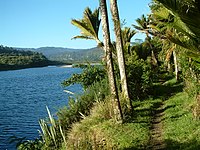 Nikau palms along the Heaphy River | |
| Location | |
| Country | New Zealand |
| Physical characteristics | |
| Mouth | |
• location | Tasman Sea (Karamea Bight) |
| Length | 26 kilometres (16 mi) |
The Heaphy River is a river of the northwestern South Island of New Zealand. It flows through Kahurangi National Park, rising on the northern slopes of and initially flowing northwest before turning southwest to reach the Tasman Sea 30 kilometres north of Karamea.[1] Stages of the Heaphy Track follow the lower course of this river, with the track reaching the coast at the river's mouth. The Heaphy River is located in the Buller District.
The river is named for Charles Heaphy, a soldier who explored the area in the 1840s.[2]
Tributaries to the Heaphy River that are named "river" are (source to sea) the Lewis River and the Gunner River.[3][4]
See also[]
Notes[]
- ^ "Place name detail: Heaphy River". New Zealand Gazetteer. New Zealand Geographic Board. Retrieved 12 July 2009.
- ^ Reed 1952, p. 44.
- ^ "Untitled". NZ Topo Map. Retrieved 1 April 2020.
- ^ "Untitled". NZ Topo Map. Retrieved 1 April 2020.
References[]
- Reed, A. W. (1952). The Story of New Zealand Place Names. Wellington: A.H. & A.W. Reed. OCLC 59066325.
Coordinates: 40°59′S 172°06′E / 40.983°S 172.100°E

Categories:
- Kahurangi National Park
- Rivers of the West Coast, New Zealand
- Rivers of New Zealand
- Buller District
- West Coast, New Zealand river stubs