Heimbach (Glatt)
This article may be expanded with text translated from the corresponding article in German. (September 2011) Click [show] for important translation instructions.
|
| Heimbach | |
|---|---|
 | |
| Location | |
| Country | Germany |
| State | Baden-Württemberg |
| Physical characteristics | |
| Mouth | |
• location | Glatt |
• coordinates | 48°23′30″N 8°32′31″E / 48.39167°N 8.54194°ECoordinates: 48°23′30″N 8°32′31″E / 48.39167°N 8.54194°E |
| Length | 24.5 km (15.2 mi) [1] |
| Basin features | |
| Progression | Glatt→ Neckar→ Rhine→ North Sea |

Heimbach is a river of Baden-Württemberg, Germany. It flows into the Glatt near Dornhan.
Geography[]
Course[]
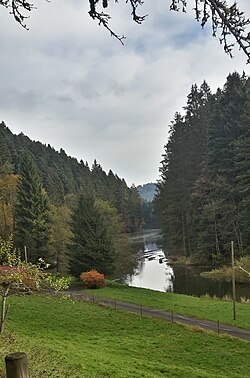
The Heimbach has its source southwest of the Schramberg district in the district of Rottweil and then flows in a largely northern direction through the community Fluorn-Winzeln, past the Alpirsbach district and the Dornhan district . Afterwards it crosses the area of the Lossburg community. After the district Wälde the small river changes its direction of flow towards the east towards the Glatt. It now flows in an arc around the district through a wooded valley, feeds a small dam below Sterneck, which is somewhat hidden in the woods, and then flows into the Glatt in the Dornhan district .
Catchment area[]
The Heimbach drains 77.4 km² on the eastern edge of the Black Forest in a north-north-eastern direction to the Neckar tributary Glatt, which flows almost in the opposite direction. The catchment areas of the following rivers border in turn:
- in the north that of the short to the upstream Glatt
- in the east only that of the likewise short , further to the south that of the Neckar
- in the south the Eschach drains into the Neckar far above the Glatt
- in the west the upper Kinzig runs in front of its large arch almost contrary to the direction of the Heimbach.
Tributaries[]
from Source to mouth:
- unknown creek, (left), 1,29 km
- Schlierbach, (right), 1,48 km
- Tannbach (!), (left), 4,03 km
- Staffelbach, (left), 4,41 km
- Tannbach (!), (left), 2,18 km
- Grüblesquellenbach (left), 1,52 km
- Obelsbach, (left), 4,81 km
- Rossbach, (left), 1,98 km
- Leinbach, (left) , 1,49 km
- Fuchsbach,(lleft), 1,91 km
- Türnenbach,(right), 2,96 km
- Wühlsbach, (left) 4,97 km
See also[]
References[]
- Tributaries of the Neckar
- Rivers of Baden-Württemberg
- Rivers of Germany