Herten
Herten | |
|---|---|
 | |
 Coat of arms | |
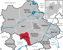
show Location of Herten within Recklinghausen district | |
 Herten | |
| Coordinates: 51°36′N 7°08′E / 51.600°N 7.133°ECoordinates: 51°36′N 7°08′E / 51.600°N 7.133°E | |
| Country | Germany |
| State | North Rhine-Westphalia |
| Admin. region | Münster |
| District | Recklinghausen |
| Subdivisions | 9 |
| Government | |
| • Mayor (2020–25) | Matthias Müller[1] |
| Area | |
| • Total | 37.31 km2 (14.41 sq mi) |
| Elevation | 75 m (246 ft) |
| Population (2020-12-31)[2] | |
| • Total | 61,860 |
| • Density | 1,700/km2 (4,300/sq mi) |
| Time zone | UTC+01:00 (CET) |
| • Summer (DST) | UTC+02:00 (CEST) |
| Postal codes | 45699, 45701 |
| Dialling codes | 0 23 66, 02 09 (Westerholt), 0 23 65 (Marl) |
| Vehicle registration | RE |
| Website | www |


Herten (German pronunciation: [ˈhɛʁtn̩] (![]() listen)) is a town and a municipality in the district of Recklinghausen, in North Rhine-Westphalia, Germany. It is situated in the industrial Ruhr Area, some 5 km (3.1 mi) west of Recklinghausen.
listen)) is a town and a municipality in the district of Recklinghausen, in North Rhine-Westphalia, Germany. It is situated in the industrial Ruhr Area, some 5 km (3.1 mi) west of Recklinghausen.
Herten was the seat of the governors of the County of Vest Recklinghausen, an autonomous state within the Archbishopric of Cologne.
Its best known sights are the moated red brick castle of Schloss Herten, dating back to the 14th century, the "altes Dorf Westerholt" (Westerholt old village) with its many historic half-timbered houses, and the former Ewald Colliery, which is a repurposed coal mine that now houses commercial space and a visitor center for green energy.
Geography[]
Town area[]
Herten covers an area of 37.31 km2, with a maximum north-south extent of 9.5 km, and a maximum east-west extent of 6.5 km. The municipality's highest natural point is in Scherlebeck, close to the border with Recklinghausen, with an altitude of 110 m.[3]
Herten is divided into the following urban districts:
|
|
|
Neighbouring towns[]
Herten borders Marl in the north, Recklinghausen in the east, Herne in the south, and Gelsenkirchen in the west.
Twin towns – sister cities[]
 Arras, France
 Doncaster, United Kingdom
 Schneeberg, Germany
 Szczytno, Poland
Notable people[]
- Adolf Galland (1912–1996), Luftwaffe General (Air Chief Marshal)
- Ludger Pistor (born 1959), actor
- Barbara Mensing (born 1960), archer
- Christian Timm (born 1979), footballer
References[]
- ^ Wahlergebnisse in NRW Kommunalwahlen 2020, Land Nordrhein-Westfalen, accessed 29 June 2021.
- ^ "Bevölkerung der Gemeinden Nordrhein-Westfalens am 31. Dezember 2020" (in German). Landesbetrieb Information und Technik NRW. Retrieved 21 June 2021.
- ^ http://www.herten.de/leben-in-herten/zahlen-daten-fakten/gemeindegebiet/index.html[permanent dead link]
- ^ "Städtepartnerschaften". herten.de (in German). Herten. Retrieved 2021-02-15.
External links[]
| Wikimedia Commons has media related to Herten. |
- Official website
 (in German)
| show Towns and municipalities in Recklinghausen (district) |
|---|
| show Authority control |
|---|
This Recklinghausen district location article is a stub. You can help Wikipedia by . |
- Towns in North Rhine-Westphalia
- Recklinghausen (district)
- Province of Westphalia
- Münster region geography stubs