Hetauda
This article needs additional citations for verification. (November 2019) |
Hetauda
हेटौंडा | |
|---|---|
Sub-Metropolitan City | |
 Hetauda City | |
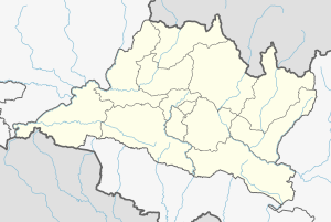 Hetauda Location in Nepal | |
| Coordinates: 27°25′N 85°02′E / 27.417°N 85.033°ECoordinates: 27°25′N 85°02′E / 27.417°N 85.033°E | |
| Country | Nepal |
| Province | Bagmati Province |
| District | Makwanpur |
| Government | |
| • Type | Mayor–council |
| • Mayor | Hari Bahadur Mahat (NCP) |
| • Deputy Mayor | Mina Kumari Lama (NCP) |
| Area | |
| • Total | 261.59 km2 (101.00 sq mi) |
| Elevation | 345 m (1,132 ft) |
| Population (2015) | |
| • Total | 154,660 [2,011] – Census |
| Time zone | UTC+5:45 (NST) |
| Post code | 44100, 44107 |
| Area code(s) | 057 |
| Website | www |


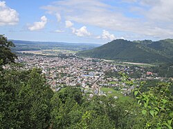
Hetauda (Nepali: हेटौडा, pronounced [heˈʈʌu̯ɽa]) is a sub-metropolitan city in the Makwanpur District of Bagmati Province in central Nepal. It is the administrative headquarters of the Makwanpur District and the capital of Bagmati Province as declared by majority (105 out of 110) Provincial Assembly Members on 12 January 2020.[1] It is one of the largest cities of Nepal. At the time of the 2015 Nepal census, it had a population of 153,875 people.[2]
Hetauda sub-metropolitan city is situated in the confluence of the two prominent national highways viz. Tribhuvan highway and Mahendra highway. It was declared a municipality in 1969 A.D (2026 B.S), but development was sluggish. Momentum increased when the city became headquarters of the Makwanpur district in 1982A.D (2039 B.S). It is regarded as a "Green city" because the city has planted trees on either sides of the road.
Hetauda is located at a distance of 76 km from the capital city, Kathmandu, via the fast track, at a distance of 132 km via Daman, Tribhuvan Highway and 224 km via Narayangadh. Another highway will be built within May 2018, and it will take only 2 hours to travel from Hetauda to Kathmandu. Also, the first road tunnel is being constructed which is believed to shorten the distance between Hetauda and Kathmandu. It is expected that traveling time from Kathmandu to Hetauda via the road tunnel will be just 57 min and 13 sec only.
Lying in the central region of the nation, it is properly situated at the central of the Makwanpur district. It lies in the 27°25' N latitude and 85°02' E longitude and is situated at a level of 300-390m above the sea level. The total area of the city is 261 km2 where around 254 km2. (97%) is land and the remaining 7 km2 (3%) consists of water. Boundary: East: Chhatiwan V.D.C West: Manahari, Haandikhola and Sarikhet V.D.C North: Naamtaar, Bhainse and Makwanpurgadhi V.D.C South: Bara and Parsa District, the city is surrounded by three rivers—the Rapti to the west, the to the north, and the Karra to the south—and is part of an important industrial regions. The settlement developed because of its location along the Tribhuvan Highway, and was later linked to another major national thoroughfare: the Mahendra Highway, also known as the East-West Highway.
Hetauda has the total population of 154,660 (2011– Census).
It was awarded as the cleanest city of Nepal in the year 2016 and 2017. Apart from natural environment, there are a number of monuments and historical sites to visit in this city like and Temple.
The largest industrial estate of Nepal also lies in Hetauda. It is commonly known as Hetauda Industrial Estate (HIE). Factories like Hetauda Cement Factory, Riddi Siddi Cements, Asian Paints, Yeti Paints industries etc. lie here.
History[]

It is believed that Hetauda got its name from Hidimba, a demonic queen who ended up marrying Bhimsen as per a story in Mahabharat. The fact that there is a place called Bhimphedi just as the plains of Hetauda meets the mountains can be considered a manifestation of this belief. During the Rana regime in Nepal, there has been a history of cars being carried by porters to Kathmandu through Bhimphedi.[3] This shows the importance of Hetauda as a trade route between Kathmandu and India for a long time in history. Before being annexed by Prithvi Narayan Shah, Sen rulers most probably ruled from Hetauda - which is evident from the fort Makwanpurgadhi just 17 km from Hetauda.
Geography[]
The city is situated in a unique geographical structure called Doon, giving it a valley-like geography.[4] It is surrounded by mountains, with the Mahabharata Range to the north and the Sivalik Hills to the south. The rivers Rapti, Samari, and Karra run through the city and flow southwest to meet the Narayani, one of the bigger rivers of Nepal.
Flora and fauna[]
The sal tree (Shorea robusta) is very common in and around the city. On the banks of the Rapti and Karra rivers, the Indian rosewood (Dalbergia sissoo) can be found interspersed with sal and other tropical species. The ashoka tree (Saraca asoca) is also part of the city's greenery. Community groups work to preserve the area's natural resources; the Rani Community Forestry User Group in particular is well known in Nepal for its intensive sustainable forest management.[citation needed]
Several government bodies—including District Forest Office Makwanpur, District Soil Conservation Office Makwanpur and District Plant Resources Office Makwanpur, under the Ministry of Forest and Soil Conservation—are headquartered in Hetauda. Some international non-governmental organizations support the sustainable development of forest resources in the area.
Economy[]
The Hetauda Industrial District (HID) is one of the biggest industrial districts in Nepal,[citation needed][5] housing large, medium-scale, and cottage industry. It was established in 1963 under technical and financial assistance of the government of United States of America. Three of the major national paint factories are situated in HID, including Asian Paints, Berger, and Yeti Paints. Because of political events in the past decade[clarification needed], however, HID has been shrinking as industries (such as the former textile industry) either move to other countries or shut down.
The city is mostly a working-class residential town, and therefore a sizable portion of the population is employed by industry or government. Trucking, since most goods bound for Kathmandu pass through Hetauda, and individual entrepreneurship are other means of livelihood. Recently, passenger service to Kathmandu using Indian Tata Sumo SUVs has taken hold.
Attractions[]
One of the most popular attractions of Hetauda is Martyr Memorial Park,[6] or Sahid Smarak (Nepali: शहीद स्मारक), which was completed in 1994. The park honors Nepalese martyrs, from those who lost their lives in the British colonial wars to those who overthrew the autocratic Panchayat system in 1989. A series of sculptures of these martyrs sit on a large boulder; their faces were sculpted by student volunteers from Lalit Kala Campus. The park is also popular as a picnic spot and as an escape from busy city life. It has a swimming pool and a zoo that houses some endangered and some common wild animals, from monkeys to leopards.
Pangolin park - A Park named after a beautiful and endangered species named pangolin. It was established in 2074 B.S by Chuchchekhola Community Forest User Committee. It is located at the eastern part of hetauda way to Makawanpur Gadhi which is randomly 6 km east from Buddha Chowk Hetauda. one can relax and spare a good time of leisure also there is a facility for Family and school Picnics. Although now the park has not been commercially started, you can still take benefits free of cost over there. Sight seeing and night viewing of city and beautiful park are the major attractions here.
Another major site is the Makwanpur Gadhi in the east of the city, a fort of historical importance dating back to the unification of Nepal. King Prithvi Narayan Shah, who led the unification process, was married to the princess of Makwanpur, whose father was a king of the Sen dynasty that ruled the region. Historians say that this marriage was a political strategy by the king, who saw that an alliance with Makwanpur could encircle Kathmandu Valley.

Other nearby tourist attractions are:
- Sahid Smarak Park
- Chisapani Gadhi
- View Tower
- Pathivara Temple
- Jurethum Lord krishna statue
- Palung Valley
- Daman Simbhanjyang
- Manakamana Temple
- Banaskhandi Temple
- Gumba Danda
- Kusmanda Sarowar Triveni Dham
- Bhutandevi Mandir
- Pangolin Park
- Churia Tunnel[7]
Transport[]
Hetauda is an hour's drive from the Nepalese border city of Birgunj, which is adjacent to Raxaul, India. Both of the existing highways to Kathmandu—the Tribhuvan Highway and the Mahendra Highway—traverse the city. Hetauda's economic prominence began with the construction of the Tribhuvan, the first highway built in the country. The eradication of malaria from the region's tropical forest paved the way for a settlement to grow.
A proposed and long-discussed new highway[citation needed] would, through a series of tunnels, reduce the driving distance to Kathmandu from 133 km to less than 60 km. Such a route, if built, could make Hetauda a transit point for trade between the fast-growing economies of India and China. Two unpaved roads currently provide a shorter route to Kathmandu for light vehicles; one goes through the villages of Fakhel and Pharping, and the other through Markhu and Sisneri. Another future transportation project that could link to the city is the Kathmandu-Nijgadh fast-track, planned to stretch approximately 77 kilometers long.
The nearest airport is Simara Airport, about a 30-minute drive from the city.
Education[]
Education in Hetauda started with the establishment of Shree Bhutan Devi Secondary School (now Shree Bhutan Devi Higher Secondary School). Some notable education institutions and University include:
- Makwanpur Multiple Campus
Health Services[]
There are various hospitals in Hetauda.
- Hetauda Hospital (Public)
- Hetauda Community Eye Hospital
- Chure Hill Hospital
- Hetauda Orthopaedic and General Hospital
- Makwanpur Sahakari Hospital
- Sancho Hospital

Media[]
Manakamana FM (92.9 MHz) was the first operating radio station of the city. Currently Hetauda has several community radio stations: Shakti FM (103.4 MHz), Radio Makwanpur FM (101.3), and Radio Kalash (89.4). Private sector FM radio stations include Hetauda FM (96.6 MHz), Radio Thaha Sanchar (99.6),Radio Sarobar (92.5), and Radio Anmol (90 Mhz).
There are several local newspapers—Hetauda Sandesh, Hetauda Today, Samridha Samaj, Hetauda Wapau, Sajha Kura, and Pradesh Dainik, Hetauda Khabarpatra weekly—and a television channel known as TeamTV.
See also[]
References[]
- ^ "PA decides to call Province 3 Bagmati, with Hetauda as its permanent HQ". The Himalayan Times. 13 January 2020. Retrieved 14 January 2020.
- ^ "Nepal Census 2001". Nepal's Village Development Committees. Digital Himalaya. Archived from the original on 12 October 2008. Retrieved 9 December 2008.
- ^ Hatuwali, Chandra Kumar. "Cars didn't carry people, people carried cars | Nepali Times Buzz | Nepali Times". archive.nepalitimes.com. Retrieved 6 April 2020.
- ^ Let us be clear that Hetauda does not lie in Terai Region but in Inner Terai.
- ^ "Industrial Districts". Retrieved 13 April 2020.
- ^ "Martyrs' Memorial Park turns tourist spot". GorakhaPatra. Retrieved 13 April 2020.
- ^ Magazine, New Spolight. "Churia Tunnel Is First Tunnel Of Nepal". SpotlightNepal. Retrieved 18 November 2019.
External links[]

| Authority control |
|---|
- Populated places in Makwanpur District
- Nepal municipalities established in 1969
- Submetropolitan municipalities of Nepal
- Nepalese capital cities
- Hetauda