Hevenor Inlet
| Hevenor Inlet | |
|---|---|
 Looking westward down Hevenor Inlet | |
 Hevenor Inlet | |
| Location | British Columbia |
| Coordinates | 53°38′28″N 129°59′17″W / 53.64111°N 129.98806°WCoordinates: 53°38′28″N 129°59′17″W / 53.64111°N 129.98806°W |
| Type | Fjord |
| Native name | [K’t’a’i[1]] Error: {{Native name}}: missing language tag (help) (language?) |
| Part of | Pitt Island (Canada) |
| Max. length | 3.4 nautical miles (6.3 km; 3.9 mi) |
| Max. width | 0.6 nautical miles (1.1 km; 0.69 mi) |
| Islands | Clark Islet, Hevenor Islet |

Hevenor Inlet is located within the traditional territory of the Gitxaala Nation, extending eastward from on the northwest side of Pitt Island, British Columbia, Canada.[2]
The inlet is entered between Stark Point[3] and Hevenor Point,[4] and contains Clark[5] and Hevenor[6] Islets. A narrow entrance connects the inlet to Hevenor Lagoon,[7] 4 nautical miles (7.4 km; 4.6 mi) southeast of the head of the inlet.[8]
Two Indian Reserves adjoin the inlet, Pitt Island 27[9] on the north shore near the entrance, and Ketai 28[10] midway down the south shore.
Hevenor Inlet is surrounded by waterfalls, including the Cascades, a linear series of waterfalls at the head of the inlet.
Image Gallery[]
| Wikimedia Commons has media related to Hevenor Inlet. |
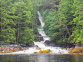
The mouth of the Cascades at the head of Hevenor Inlet

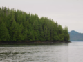
Fog lifting around Clark Islet

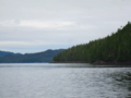
The narrows between the Inlet and the Lagoon

Looking at Hevenor Islet from the southwest
Stark Point, south of the mouth of Hevenor Inlet
Hevenor Point, north of the mouth of Hevenor Inlet


References[]
- ^ MARSDEN S. REPORT SUBMITTED TO (2011). THE GITKXAALA, THEIR HISTORY, AND THEIR TERRITORIES (PORCHER ISLAND, BANKS ISLAND, PITT ISLAND AND ADJACENT ISLANDS) (pdf) (Report). JANES FREEDMAN KYLE LAW CORPORATION. p. 55.CS1 maint: uses authors parameter (link)
- ^ "Hevenor Inlet". BC Geographical Names.
- ^ "Stark Point". BC Geographical Names.
- ^ "Hevenor Point". BC Geographical Names.
- ^ "Clark Islet". BC Geographical Names.
- ^ "Hevenor Inlet". BC Geographical Names.
- ^ "Hevenor Lagoon". BC Geographical Names.
- ^ "Chart 3746, Petrel Channel". Sailing Directions, British Columbia Coast, (Northern Portion). II (Ninth Edition): 259. 1983.
- ^ "Pitt Island 27". BC Geographical Names.
- ^ "Ketai 28". BC Geographical Names.
This article about a location on the Coast of British Columbia, Canada is a stub. You can help Wikipedia by . |
- North Coast of British Columbia
- Inlets of British Columbia
- British Columbia Coast geography stubs