Hidden Lake (Flathead County, Montana)
| Hidden Lake | |
|---|---|
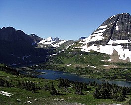 Hidden Lake from the Hidden Lake overlook. Bearhat Mountain rises above the lake at right. | |
 Hidden Lake | |
| Location | Glacier National Park, Flathead County, Montana, US |
| Coordinates | 48°40′35″N 113°44′29″W / 48.67639°N 113.74139°WCoordinates: 48°40′35″N 113°44′29″W / 48.67639°N 113.74139°W[1] |
| Lake type | Natural |
| Primary outflows | Hidden Creek |
| Basin countries | United States |
| Max. length | 2 mi (3.2 km) |
| Max. width | .40 mi (0.64 km) |
| Surface elevation | 6,375 ft (1,943 m) |


Hidden Lake is located in Glacier National Park, in the U. S. state of Montana.
Hidden Lake is surrounded by numerous peaks, including Bearhat Mountain to the southwest, Dragons Tail to the south, Clements Mountain to the north, and Reynolds Mountain to the east.[2] Hidden Lake is a popular day hike destination, with the Hidden Lake overlook a 1.5-mile (2.4 km) hike from Logan Pass, and the lakeshore adding another 1.5 miles (2.4 km) one way.[3]

See also[]
- List of lakes in Flathead County, Montana (A-L)
References[]
- ^ "Hidden Lake". Geographic Names Information System. United States Geological Survey. Retrieved 2011-02-20.
- ^ "Logan Pass, MT" (Map (USGS Quad)). TopoQuest. Retrieved 2011-02-20.
- ^ "Day Hikes" (pdf). Plan Your Visit. National Park Service. Retrieved 2011-02-20.
This Flathead County, Montana state location article is a stub. You can help Wikipedia by . |
Categories:
- Lakes of Glacier National Park (U.S.)
- Lakes of Flathead County, Montana
- Going-to-the-Sun Road
- Flathead County, Montana geography stubs