Hinteri Egg
| Hinteri Egg | |
|---|---|
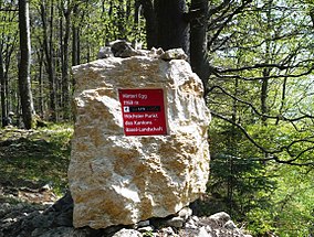 On the summit | |
| Highest point | |
| Elevation | 1,169 m (3,835 ft) |
| Prominence | 165 m (541 ft)[1] |
| Parent peak | Vogelberg (1,204 m) |
| Listing | Canton high point |
| Coordinates | 47°22′21.3″N 7°42′38.4″E / 47.372583°N 7.710667°ECoordinates: 47°22′21.3″N 7°42′38.4″E / 47.372583°N 7.710667°E |
| Geography | |
 Hinteri Egg Location in Switzerland | |
| Location | Basel-Landschaft, Switzerland |
| Parent range | Jura Mountains |

The Hinteri Egg is a mountain of the Jura, located south of Reigoldswil in the Swiss canton of Basel-Landschaft, close to the border with the canton of Solothurn.
The Hinteri Egg reaches a height of 1,169 metres above sea level and is the highest point of the canton of Basel-Landschaft.
References[]
External links[]
Categories:
- Mountains of Switzerland
- Mountains of Basel-Landschaft
- Highest points of Swiss cantons
- Mountains of the Jura
- One-thousanders of Switzerland